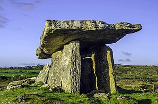
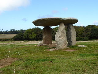
A dolmen or portal tomb is a type of single-chamber megalithic tomb, usually consisting of two or more upright megaliths supporting a large flat horizontal capstone or "table". Most date from the early Neolithic and were sometimes covered with earth or smaller stones to form a tumulus. Small pad-stones may be wedged between the cap and supporting stones to achieve a level appearance. In many instances, the covering has eroded away, leaving only the stone "skeleton".

Newquay is a town on the north coast in Cornwall, in the south west of England. It is a civil parish, seaside resort, regional centre for aerospace industries, spaceport and a fishing port on the North Atlantic coast of Cornwall, approximately 12 miles (19 km) north of Truro and 20 miles (32 km) west of Bodmin.

Lanyon Quoit is a dolmen in Cornwall, England, United Kingdom, 2 miles southeast of Morvah. It collapsed in a storm in 1815 and was re-erected nine years later, and as a result the dolmen is now very different from its original appearance.

St Columb Major is a town and civil parish in Cornwall, England, United Kingdom. Often referred to locally as St Columb, it is approximately seven miles (11 km) southwest of Wadebridge and six miles (10 km) east of Newquay The designation Major distinguishes it from the nearby settlement and parish of St Columb Minor on the coast. An electoral ward simply named St Columb exists with a population at the 2011 census of 5,050. The town is named after the 6th-century AD Saint Columba of Cornwall, also known as Columb.

Hurling is an outdoor team game played only in Cornwall, England played with a small silver ball. While the sport shares its name with the Irish game of hurling, the two sports are completely different.

The Atlantic Coast Line is a 20+3⁄4-mile (33 km) Network Rail branch line which includes a community railway service in Cornwall, England. The line runs from the English Channel at Par, to the Atlantic Ocean at Newquay.

St Columb Road is a small village near Fraddon and Indian Queens in Cornwall, England, United Kingdom. It lies half a mile (750m) from the A30 road. St Columb Road railway station is on the branch line from Par to Newquay. When it opened in 1876 the station was called Halloon. It was renamed soon afterwards to reflect the existence of St Columb Major further north, and the new name was adopted for the local settlement which followed.

St Columb Minor is a village on the north coast of Cornwall, England, United Kingdom.

St Wenn is a civil parish and village in Cornwall, England, United Kingdom. The village is situated six miles (10 km) west of Bodmin and nine miles (14.5 km) east of Newquay. The parish population at the 2011 census was 369.

St Columb Road railway station serves the village of St Columb Road in Cornwall, England. The station is situated on the Atlantic Coast Line, 296 miles 11 chains measured from London Paddington. All services are operated by Great Western Railway, which also manages the station.

Tregaswith is a hamlet in the parish of St Columb Major, Cornwall. It is situated to the south-west of the town of St Columb, and just south of the A3059 main road between St Columb and Newquay. The hamlet is about 1 mile from RAF St Mawgan airfield.

St Enoder is a civil parish and hamlet in Cornwall, United Kingdom. The hamlet is situated five miles (8 km) southeast of Newquay. There is an electoral ward bearing this name which includes St Columb Road. The population at the 2011 census was 4,563.

Porth is a seaside hamlet in the civil parish of Newquay, Cornwall, United Kingdom.
St Dennis Junction was in St Dennis, Cornwall.

Lanivet is a village and civil parish in Cornwall, England, United Kingdom. The village is situated approximately 2+1⁄2 miles (4.0 km) southwest of Bodmin, and before the Bodmin by-pass was built, the A30 road between London and Land's End passed through the village. The Saints' Way long-distance footpath passes Lanivet near its half-way point.

St Breock is a village and a civil parish in north Cornwall, England, United Kingdom. The spelling St Breoke was also formerly in use.
Carwynnen Quoit is a dolmen belonging to the Neolithic period, at Carwynnen near Camborne in west Cornwall. It is also known as 'The Giant's Quoit', 'The Giant's Frying Pan', 'Pendarvis Quoit' and 'Pendarves Quoit'. It collapsed in 1966 and was re-erected in 2014.
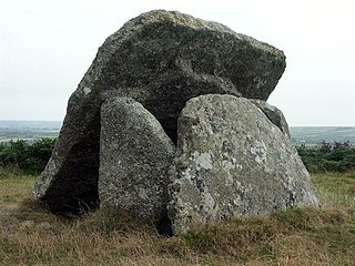
Mulfra Quoit is a Neolithic dolmen in the county of Cornwall in England. It stands on Mulfra Hill to the north of the hamlet of Mulfra.
The following is a timeline of the history of St Columb Major, Cornwall, England, United Kingdom.
Presented below is an alphabetical index of articles related to Cornwall:

