Rame, Maker-with-Rame

Last updated

Rame
Rame, near Plymouth - geograph.org.uk - 294448.jpg
Rame viewed from the sea
Cornwall UK mainland location map.svg
Red pog.svg
Rame
Location within Cornwall
OS grid reference SX425494
Civil parish
Unitary authority
Ceremonial county
Region
Country England
Sovereign state United Kingdom
Post town TORPOINT
Postcode district PL10
Dialling code 01752
Police Devon and Cornwall
Fire Cornwall
Ambulance South Western
UK Parliament
List of places
UK
England
Cornwall
50°19′29″N4°12′48″W / 50.3246°N 4.2133°W / 50.3246; -4.2133

Rame (Cornish : Hordh) is a village and former civil parish, now in the parish of Maker-with-Rame, in the Cornwall district, in the ceremonial county of Cornwall, England. It is situated on the Rame Peninsula, between Rame Head and the village of Cawsand, in South East Cornwall. In 1931 the parish had a population of 501. [1] On 1 April 1950 the parish was abolished and merged with Maker to form "Maker with Rame". [2] Rame means the high protruding cliff, or possibly, the ram's head.

Contents

Cawsand was previously in the parish of Rame [ citation needed ] but now has its own church. The parish of 'Maker-with-Rame' is formed of the hamlets Maker, which also has a church and Rame. Rame was recorded in the Domesday Book of 1086, when it was held by Ermenhald from Tavistock Abbey. There were 27 households, land for 6 ploughs, 10 acres of pasture and 30 acres of underwood. [3] An electoral division bearing the same name also existed, but was succeeded by the Rame Peninsula division. The population as of the 2011 census was 4,763. [4]

There is another Rame near Falmouth in west Cornwall. It is believed that the west Cornwall Rame was named after the one on the Rame Peninsula.[ citation needed ]

During his time in command of the Channel Fleet between 1805 and 1807 John Jervis, 1st Earl of St Vincent rented a house in Rame. [5]

Parish church

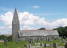
Rame Church Rame Church - geograph.org.uk - 36825.jpg
Rame Church

The church in the hamlet is dedicated to St. Germanus, the fighting bishop who is supposed to have landed in the neighbourhood when he came to Britain to suppress the Pelagian heresy in 400. The site however is also an ancient Cornish pagan holy site. Built of rough slate, the present stone building was consecrated in 1259. The slender, un-buttressed tower with its broached spire (an unusual feature in a Cornish church), the north wall and the chancel are all probably of this date, when the church was cruciform in shape. A southern aisle was added in the 15th century and the Norman tympanum is a relic of the earlier church building on the site. [6] The church is not supplied with electricity and so is lit by candles.

Related Research Articles

<span class="mw-page-title-main">Cawsand</span> Human settlement in England

Cawsand and Kingsand are twin villages in southeast Cornwall, England, United Kingdom. The village is situated on the Rame Peninsula and is in the parish of Maker-with-Rame.

<span class="mw-page-title-main">Littleton-upon-Severn</span> Human settlement in England

Littleton-upon-Severn is a village and former civil parish, now in the parish of Aust, in the South Gloucestershire district, in the ceremonial county of Gloucestershire, England, near the mouth of the River Severn and is located to the west of Thornbury. Historically it belonged to the Hundred of Langley and Swinehead. In 1931 the parish had a population of 179. On 1 April 1935 the parish was abolished and merged with Aust.

<span class="mw-page-title-main">Millbrook, Cornwall</span> Human settlement in England

Millbrook is a civil parish and village in southeast Cornwall, England, United Kingdom. The village is situated on the Rame Peninsula four miles (6.5 km) south of Saltash. The population of Millbrook was 2,033 in the 2001 census, increasing to 2,214 at the 2011 census.

The Rame Peninsula is a peninsula in south-east Cornwall. The peninsula is surrounded by the English Channel to the south, Plymouth Sound to the east, the Hamoaze to the northeast and the estuary of the River Lynher to the northwest. On a clear day, the Atlantic Ocean can be seen from advantageous points from Rame Head. The largest settlement is Torpoint, which is on the eastern coast, facing Devonport in Plymouth, Devon.

<span class="mw-page-title-main">St Mabyn</span> Human settlement in England

St Mabyn is a civil parish and village in Cornwall, England, United Kingdom. The village is situated three miles (5 km) east of Wadebridge. The parish includes a hamlet called Longstone to the east and many small manor houses, including Tregarden, Tredethy, Helligan Barton and Colquite, all built in the 16th and 17th centuries. The area of the parish is 4,101 acres (16.60 km2).

<span class="mw-page-title-main">Kingsand</span> Village in Cornwall, England

Kingsand and Cawsand are twin villages in southeast Cornwall, United Kingdom. The villages are situated on the Rame Peninsula and are in the parish of Maker-with-Rame.

<span class="mw-page-title-main">Talland</span> Human settlement in England

Talland is a hamlet and ecclesiastical parish and former civil parish, between Looe and Polperro, now in the parish of Polperro, in the Cornwall district, on the south coast of Cornwall, England. It consists of a church, the Old Vicarage and a few houses. In 1931 the parish had a population of 768. On 1 April 1934 the civil parish was abolished and merged with Lansallos, part also went to form Looe.

<span class="mw-page-title-main">Poughill</span> Human settlement in England

Poughill is a village and former civil parish, now in the parish of Bude-Stratton, in the Cornwall district, in north-east Cornwall, England, United Kingdom. It is located one mile north of Bude. In 1931 the parish had a population of 413.

<span class="mw-page-title-main">Gulval</span> Village in Cornwall, England

Gulval is a village in Cornwall, England, United Kingdom. Although historically a parish in its own right, Gulval was incorporated into the parishes of Ludgvan, Madron and Penzance in 1934, and is now considered to be a suburb of Penzance. Gulval still maintains its status as an ecclesiastical parish and parts of the village church date back to the 12th-century. Together with Heamoor, Gulval still retains its status as an electoral ward. The ward population at the 2011 census was 4,185.

<span class="mw-page-title-main">Stratton, Cornwall</span> Town in Cornwall, England

Stratton is a market town and former civil parish, now in the parish of Bude-Stratton, in Cornwall, England, United Kingdom. It is situated near the coastal town of Bude and the market town of Holsworthy. It was also the name of one of ten ancient administrative hundreds of Cornwall. The Battle of Stratton during the English Civil War took place here on 16 May 1643.

<span class="mw-page-title-main">Wendy, Cambridgeshire</span> Human settlement in England

Wendy is a hamlet and former civil parish, now in the parish of Shingay cum Wendy, in the South Cambridgeshire district, in the county of Cambridgeshire, England around 5 miles north west of Royston. In 1951 the parish had a population of 81.

<span class="mw-page-title-main">Lowthorpe</span> Village in the East Riding of Yorkshire, England

Lowthorpe is a village and former civil parish, now in the parish of Harpham, in the East Riding of Yorkshire, England. It is situated approximately 3 miles (5 km) north-east of Driffield town centre and 7 miles (11 km) south-west of Bridlington town centre. In 1931 the parish had a population of 159. On 1 April 1935 the parish was abolished and merged with Harpham.

<span class="mw-page-title-main">Goxhill, East Riding of Yorkshire</span> Hamlet in the East Riding of Yorkshire, England

Goxhill is a small hamlet in the civil parish of Hatfield, in the East Riding of Yorkshire, England in an area known as Holderness. It is situated approximately 2 miles (3.2 km) south-west of Hornsea town centre. In 1931 the parish had a population of 70.

<span class="mw-page-title-main">Forgotten Corner of Cornwall</span> Geographical area of South East Cornwall, England

The Forgotten Corner of Cornwall is a geographical area of South East Cornwall, Great Britain. It includes the Rame Peninsula and the town of Torpoint, as well as villages like Antony, Downderry, Polbathic, Portwrinkle and Widegates.

<span class="mw-page-title-main">Maker, Cornwall</span> Village in Cornwall, England

Maker is a village between Cawsand and Rame Head, Rame Peninsula, Cornwall, England, United Kingdom.

<span class="mw-page-title-main">Baverstock</span> Human settlement in England

Baverstock is a small village and former civil parish, now in the parish of Dinton, in Wiltshire, England, about 7 miles (11 km) west of Salisbury. The village has 10 private dwellings, a church and several farm buildings. The manor of Hurdcott, a hamlet of a few houses, lies to the southwest of the village. In 1931 the parish had a population of 43.

Maker-with-Rame is a civil parish in Cornwall, England, United Kingdom. It is situated on the Rame Peninsula, approximately four miles (6.5 km) south of Saltash and two miles (3 km) west of Plymouth.

<span class="mw-page-title-main">Temple, Cornwall</span> Human settlement in England

Temple is a small village and former civil parish, now in the parish of Blisland, on Bodmin Moor, in the Cornwall district, in the ceremonial county of Cornwall, England. The village is bypassed by the A30 road. In 1931 the parish had a population of 29.

<span class="mw-page-title-main">St Andrew's Church, Cawsand</span> Church in Cornwall, England

St Andrew's Church is a Church of England church in Cawsand, Cornwall, England, UK. The church was built in 1877–78 and has been Grade II listed since 1987.

<span class="mw-page-title-main">St Paul's Church, Kingsand</span>

St Paul's Church is a former Church of England church in Kingsand, Cornwall, England, UK. Built in 1881–82, the church ceased use as a place of worship after 1943 and is now used as the Maker with Rame Community Hall.

References

  1. "Population statistics Rame AP/CP through time". A Vision of Britain through Time . Retrieved 9 May 2023.
  2. "Relationships and changes Rame AP/CP through time". A Vision of Britain through Time. Retrieved 9 May 2023.
  3. Thorn, C., et al., eds. (1979) Cornwall. (Domesday Book; 10.) Chichester: Phillimore; entry 3,3
  4. "Ward population 2011" . Retrieved 11 February 2015.
  5. Davidson, James D.G. (18 September 2006). Admiral Lord St Vincent: Saint or Tyrant?: The Life of Sir John Jervis, Nelson's Patron. Pen and Sword. pp. Chapter 18.
  6. Pevsner, Nikolaus, Cornwall: The Buildings of England, 2nd ed. rev. by E. Radcliffe, Penguin Books, 1970.

Commons-logo.svg Media related to Rame, Maker-with-Rame at Wikimedia Commons