This article needs additional citations for verification .(June 2015) |
Rame
| |
|---|---|
 Rame viewed from the sea | |
 Rame Location within Cornwall | |
| OS grid reference | SX425494 |
| Civil parish | |
| Unitary authority | |
| Ceremonial county | |
| Region | |
| Country | England |
| Sovereign state | United Kingdom |
| Post town | TORPOINT |
| Postcode district | PL10 |
| Dialling code | 01752 |
| Police | Devon and Cornwall |
| Fire | Cornwall |
| Ambulance | South Western |
| UK Parliament | |
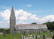
Rame (Cornish : Rama) is a village and former civil parish, now in the parish of Maker-with-Rame, in the Cornwall district, in the ceremonial county of Cornwall, England. It is situated on the Rame Peninsula, between Rame Head and the village of Cawsand, in South East Cornwall. In 1931 the parish had a population of 501. [1] On 1 April 1950 the parish was abolished and merged with Maker to form "Maker with Rame". [2] Rame means the high protruding cliff, or possibly, the ram's head.
Contents
Cawsand was previously in the parish of Rame [ citation needed ] but now has its own church. The parish of 'Maker-with-Rame' is formed of the hamlets Maker, which also has a church and Rame. Rame was recorded in the Domesday Book of 1086, when it was held by Ermenhald from Tavistock Abbey. There were 27 households, land for 6 ploughs, 10 acres of pasture and 30 acres of underwood. [3] An electoral division bearing the same name also existed, but was succeeded by the Rame Peninsula division. The population as of the 2011 census was 4,763. [4]
There is another Rame near Falmouth in west Cornwall. It is believed that the west Cornwall Rame was named after the one on the Rame Peninsula.[ citation needed ]
During his time in command of the Channel Fleet between 1805 and 1807 John Jervis, 1st Earl of St Vincent rented a house in Rame. [5]