Redberry Lake (Saskatchewan)

Last updated

Redberry Lake
Redberry Lake.jpg
Redberry Lake
Canada Saskatchewan relief location map.jpg
Red pog.svg
Redberry Lake
Location in Saskatchewan
Canada relief map 2.svg
Red pog.svg
Redberry Lake
Redberry Lake (Canada)
Location RM of Redberry No. 435, Saskatchewan
Coordinates 52°42′N107°10′W / 52.700°N 107.167°W / 52.700; -107.167
Type Salt lake
Primary inflows Marshy Creek, natural springs
Primary outflows None
Basin  countries Canada
Max. length9.7 km (6.0 mi)
Max. width9.7 km (6.0 mi)
Surface area5,169 ha (12,770 acres)
Average depth+/- 11 m (36 ft)
Max. depth18 m (59 ft)
Shore length153 km (33 mi)
Surface elevation507 m (1,663 ft)
Islands
  • Gramiak Island
  • Pelican Island
  • Gull Island
  • Old Tern Island
  • New Tern Island
SettlementsNone
1 Shore length is not a well-defined measure.

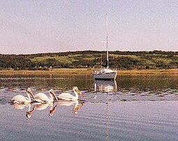
Redberry Lake [1] is a kettle salt lake near Hafford in the Canadian province of Saskatchewan. Named after the buffaloberry, it is a medium-sized saline lake within an area characterized by mostly fresh water aquatic environments. The lake makes up the core protected area of the Redberry Lake (UNESCO) Biosphere Reserve and is a federal bird sanctuary of the same name. It is also an Important Bird Area (IBA) of Canada and its northern most island is the location of the provincial Redberry Wildlife Refuge ( 52°42′00″N107°12′02″W / 52.7001°N 107.2006°W / 52.7001; -107.2006 ). [2] A small regional park is situated at the north-west corner of the lake. The countryside surrounding Redberry Lake is typical of the aspen parkland biome of which it is a part. [3] [4] [5]

Contents

Over the past several decades, Redberry Lake water levels have been declining and the salt concentrations increasing. With the declining levels, the shoreline length has been decreasing and the size of the islands in the lake have been increasing. In 1957, a new island — New Tern Island — appeared. In the 1940s, the salt content was low enough that there was a thriving commercial whitefish industry at the lake.

Lake levels and salinity

Redberry Lake water levels have been steadily declining and getting saltier over the past several decades. In 1974, the surface of the lake had an elevation of 515 m (1,690 ft) and an area of 53.42 km2 (20.63 sq mi). That compares to 507 m (1,663 ft) and 51.69 km2 (19.96 sq mi) [6] in the mid-2020s. In 1926, the salt concentration was 12g/L and by 1988 that had doubled to 24g/L. The increase was attributed to "declining lake depth during drought". Magnesium, sodium, and sulphate make up most of the salt in Redberry Lake.

In 1940–41 with the salt content at only 15g/L, Donald Rawson [7] from the University of Saskatchewan's biology department stocked Redberry Lake with whitefish (Coregonus clupeaformis). The fish thrived and in 1946 a commercial fishery was established. By 1981, though, the salt content had reached 20g/L and the fish could not survive, thus ending the fishery. [8]

Redberry Lake IBA

The Redberry Lake (SK 005) Important Bird Area (IBA) of Canada [9] encompasses the entire lake and much of the surrounding shoreline. The lake and its islands are important nesting areas for birds such as American white pelicans, piping plovers, and whooping cranes. The total area protected is 136.17 square kilometres (52.58 sq mi). [10]

Redberry Lake Regional Park

Redberry Lake Regional Park ( 52°42′43″N107°13′01″W / 52.7120°N 107.217°W / 52.7120; -107.217 ), [11] which was founded in 1969, offers camping, golfing, swimming, hiking, boating, and many bird watching opportunities. Although there are no sport fish in the lake itself, the park has installed a small earthen dam on a creek which flows into the lake, creating a freshwater trout pond. [12] [13] The golf course, built in 1971, is a 9-hole, par 35 course. It has sand greens and is 2,304 yards. [14]

Access to the park and its amenities is from Highway 40. [15]

See also

Related Research Articles

<span class="mw-page-title-main">South Saskatchewan River</span> River in Western Canada

The South Saskatchewan River is a major river in the Canadian provinces of Alberta and Saskatchewan. The river begins at the confluence of the Bow and Oldman Rivers in southern Alberta and ends at the Saskatchewan River Forks in central Saskatchewan. The Saskatchewan River Forks is the confluence of the South and North Saskatchewan Rivers and is the beginning of the Saskatchewan River.

Primrose Lake is a large lake in the Canadian provinces of Saskatchewan and Alberta in the Churchill River drainage basin. The lake straddles the Saskatchewan / Alberta border, with most of the water surface in Saskatchewan with only the south-west corner of the lake in Alberta. On the Saskatchewan side of the lake is Backes Island Wildlife Refuge, which is a small protected island near the middle of the lake that is important to birds. The entire lake plus surrounding land totalling 1,259.52 km2 (486.30 sq mi) is part of an Important Bird Area (IBA) of Canada.

<span class="mw-page-title-main">Turtle Lake (Saskatchewan)</span> Lake in Saskatchewan, Canada

Turtle Lake is a lake in the west-central part of the Canadian province of Saskatchewan. It is fairly long while also narrow. The closest town is Livelong and the closest cities are North Battleford, Meadow Lake, and Lloydminster. Turtle Lake is a heavily utilized recreational lake with campgrounds and small resort villages along its shores. Access to the lake and its amenities is from Highways 697 and 795.

<span class="mw-page-title-main">Biggar (electoral district)</span> Provincial electoral district in Saskatchewan, Canada

Biggar was a provincial electoral district for the Legislative Assembly of Saskatchewan, Canada. This former constituency, located in west central Saskatchewan, has an economy based primarily on mixed farming and alfalfa production, and oil production. Biggar is home to Prairie Malt Ltd. and is situated in the heart of Canada's prime barley-growing region. The Miller Western Palo Salt Mine is located 27 km west of Biggar. The 25 staff members produce sodium sulfate for shipping throughout Canada and the central United States. The major communities are Biggar (2,243), Wilkie (1,282) and Langham (1,145).

<span class="mw-page-title-main">Lake Diefenbaker</span> Lake in Saskatchewan, Canada

Lake Diefenbaker is a reservoir and bifurcation lake in southern part of the Canadian province of Saskatchewan. It was formed by the construction of Gardiner Dam and the Qu'Appelle River Dam across the South Saskatchewan and Qu'Appelle Rivers respectively. Construction began in 1959 and the lake was filled in 1967. The lake is 225 kilometres (140 mi) long with approximately 800 kilometres (500 mi) of shoreline. It has a maximum depth of 66 metres (217 ft), while the water levels regularly fluctuate 3–9 metres (9–27 feet) each year. The flow of the two rivers is now regulated with a considerable portion of the South Saskatchewan diverted into the Qu'Appelle. Prior to the dams' construction, high water levels in the South Saskatchewan would frequently cause dangerous ice conditions downstream in Saskatoon while the Qu'Appelle would frequently dry up in the summer months.

<span class="mw-page-title-main">Rural Municipality of Leask No. 464</span> Rural municipality in Saskatchewan, Canada

The Rural Municipality of Leask No. 464 is a rural municipality (RM) in the Canadian province of Saskatchewan within Census Division No. 16 and SARM Division No. 5. It is located west of the city of Prince Albert.

<span class="mw-page-title-main">Last Mountain Lake</span> Lake in Saskatchewan, Canada

Last Mountain Lake, also known as Long Lake, is a prairie lake formed from glaciation 11,000 years ago. It is located in south central Saskatchewan, Canada, about 40 kilometres (25 mi) north-west of the city of Regina. It flows into the Qu'Appelle River via Last Mountain Creek, which flows past Craven. It is approximately 93 km (58 mi) long, and 3 km (1.9 mi) wide at its widest point. It is the largest naturally occurring body of water in southern Saskatchewan. Only Lake Diefenbaker, which is man-made, is larger. The lake is a popular resort area for residents of south-eastern Saskatchewan.

<span class="mw-page-title-main">Carrot River (Saskatchewan)</span> River in Western Canada

Carrot River is a river in Western Canada in the north-eastern part Saskatchewan and the north-western part of Manitoba. The outlet of Wakaw Lake in Saskatchewan marks the beginning of the Carrot River and, from there, it flows north-east past several communities and Indian reserves until it joins the Saskatchewan River in the Cumberland Delta in Manitoba. The river's mouth is west and upstream of the Pasquia River and The Pas on the Saskatchewan River.

Highway 40 is a provincial highway in the north-west portion of the Canadian province of Saskatchewan connecting Alberta to Highway 3, four kilometres (2.5 mi) west of Shellbrook, Saskatchewan. Areas of this highway between the Alberta border and North Battleford are called the Poundmaker Trail. Pitikwahanapiwiyin, commonly known as Poundmaker, was a Plains Cree chief known as a peacemaker and defender of his people. This is a primary Saskatchewan highway maintained by the provincial government. The highway is about 280 kilometres (174 mi) long and is entirely paved.

<span class="mw-page-title-main">Rural Municipality of Blaine Lake No. 434</span> Rural municipality in Saskatchewan, Canada

The Rural Municipality of Blaine Lake No. 434 is a rural municipality (RM) in the Canadian province of Saskatchewan within Census Division No. 16 and SARM Division No. 5. The RM extends east to the North Saskatchewan River and north to the village of Marcelin.

<span class="mw-page-title-main">Manitou Lake (Saskatchewan)</span> Salt lake in Saskatchewan, Canada

Manitou Lake is a salt lake located mostly in the RM of Manitou Lake No. 422 in the Canadian province of Saskatchewan, about 10 kilometres (6.2 mi) east of the provincial border with Alberta. The eastern shore of the lake is in the RM of Hillsdale No. 440. Manitou Lake is located in a region called the Prairie Pothole Region of North America, which extends throughout three Canadian provinces and five U.S. states. It is also within Palliser's Triangle and the Great Plains ecoregion. Manitou Lake is part of an Important Bird Area (IBA) of Canada that covers 699.66 km2 (270.14 sq mi) of land and serval neighbouring lakes.

<span class="mw-page-title-main">Big Muddy Badlands</span> Badlands in southern Saskatchewan, Canada and northern Montana, United States

The Big Muddy Badlands are a series of badlands in southern Saskatchewan, Canada, and northern Montana, United States, in the Big Muddy Valley and along Big Muddy Creek. Big Muddy Valley is a cleft of erosion and sandstone that is 55 kilometres (34 mi) long, 3.2 kilometres (2.0 mi) wide, and 160 metres (520 ft) deep.

Big River is a town located on the southern end of Cowan Lake in north central Saskatchewan, Canada. It is just north of Saskatchewan's extensive grain belt on Highway 55 and about 16 kilometres (10 mi) west of Prince Albert National Park. Delaronde Lake is accessed east of the town. Big River is approximately 132 kilometres (82 mi) from Prince Albert.

<span class="mw-page-title-main">Lenore Lake</span> Lake in Saskatchewan, Canada

Lenore Lake is a partly saline lake in the Canadian province of Saskatchewan. It is part of the Lenore Lake basin, which includes several saline lakes as well as the fresh water St. Brieux and Burton Lakes. The basin is part of the Carrot River watershed but has no natural outlet. The lake is within the aspen parkland ecozone of Saskatchewan. Lenore Lake was designated a migratory bird sanctuary in 1925. Raven Island, located at the southern end of Lenore Lake, is a National Wildlife Area of Canada.

<span class="mw-page-title-main">Tobin Lake</span> Reservoir in Saskatchewan, Canada

Tobin Lake is a reservoir along the course of the Saskatchewan River in the Canadian province of Saskatchewan. Tobin Lake was formed by the building of the E.B. Campbell Dam on the Saskatchewan River in 1963. Tobin Lake is named for William Thorburn, who was a fur trader on the Saskatchewan River. He had built a trading post on the Saskatchewan River where it is met by the Petaigan River. The rapids near the post became known as the "Thornburn Rapids". The name was later shortened to "Tobin Rapids".

<span class="mw-page-title-main">Rural Municipality of Redberry No. 435</span> Rural municipality in Saskatchewan, Canada

The Rural Municipality of Redberry No. 435 is a rural municipality (RM) in the Canadian province of Saskatchewan within Census Division No. 16 and SARM Division No. 5.

<span class="mw-page-title-main">Blackstrap Lake</span> Reservoir in Saskatchewan, Canada

Blackstrap Lake is a man-made reservoir in central Saskatchewan, Canada, south of Saskatoon in the Rural Municipality of Dundurn No. 314. The lake was created as a reservoir in 1967, as part of the Saskatoon South East Water Supply System. Blackstrap Lake has an area of 1,200 ha and is generally used to support irrigation, and the industrial and municipal water supply.

<span class="mw-page-title-main">Redberry Lake Biosphere Reserve</span> UNESCO Biosphere Reserve in Saskatchewan, Canada

The Redberry Lake Biosphere Region was established in 2000 as a UNESCO Biosphere Reserve covering 112,200 hectares in the province of Saskatchewan, Canada. In 2019, the reserve expanded to become a region including the Redberry Lake watershed and surrounding land encompassing close to 700,000 hectares of land. The regional landscape is composed of rolling prairie dotted with seasonal ponds and marshes along with aspen/shrub groves. The core area is Redberry Lake, a saline lake with several islands. The lake is also an Important Bird Area (IBA) of Canada. There are small patches of natural mixed prairie which are very rare in this highly grazed and cultivated part of the prairies. The Redberry Lake Biosphere Region is committed to balancing conservation with sustainable development.

Wood River is a river in the Canadian province of Saskatchewan. It has its source in the Wood Mountain Hills of south-western Saskatchewan and flows in a north-easterly direction to its mouth at Old Wives Lake. Old Wives Lake is a salt water lake with no outflow. As a result, the drainage basin of Wood River is an endorheic one. Along the course of the river, there are several parks, historical sites, and small towns.

Fife Lake is a fresh water prairie lake in the Canadian province of Saskatchewan. It is in the south-central part of the province at the eastern end of the Wood Mountain Hills. The entire lake and its shoreline is designated an Important Bird Area (IBA) of Canada to protect the nationally endangered piping plover. While there are no communities along the lake's shore, there is a park and campground at the southern end. Nearby communities include Fife Lake, Rockglen, and Lisieux. Access is from Highway 18.

References

  1. "Redberry Lake". Canadian Geographical Names Database. Government of Canada. Retrieved 1 December 2022.
  2. "Redberry Wildlife Refuge". Canadian Geographical Names Database. Government of Canada. Retrieved 10 June 2024.
  3. "Redberry Lake Biosphere Region". Redberry Lake. Retrieved 1 December 2022.
  4. "Redberry Lake Fishing Map". GPS Nautical Charts. Bist LLC. Retrieved 11 June 2024.
  5. "Redberry Lake". Angler's Atlas. Retrieved 11 June 2024.
  6. Siemens, Matthew. "Redberry Lake". Sask Lakes. Retrieved 11 June 2024.
  7. Hammer, U. Theodore. "Rawson, Donald Strathearn (1905-61)". ESask. University of Regina. Retrieved 11 June 2024.
  8. Hammer, U. Theodore. "Redberry Lake". ESask. University of Regina. Retrieved 11 June 2024.
  9. "Important Bird and Biodiversity Areas". Nature Saskatchewan. Retrieved 1 December 2022.
  10. "Redberry Lake". IBA Canada. Birds Canada. Retrieved 1 December 2022.
  11. "Redberry Lake Regional Park Lake". Canadian Geographical Names Database. Government of Canada. Retrieved 1 December 2022.
  12. "Redberry Lake". Regional Parks of Saskatchewan. Saskatchewan Regional Parks. Retrieved 19 August 2023.
  13. "Redberry Lake Regional Park". BRMB Maps. Mussio Ventures Ltd. Retrieved 11 June 2024.
  14. "Redberry Lake Regional Park Golf Course". GolfPass. Retrieved 19 August 2023.
  15. "Redberry Lake Regional Park". Tourism Saskatchewan. Government of Saskatchewan. Retrieved 11 June 2024.