
Helsinki is the capital and most populous city in Finland. It is on the shore of the Gulf of Finland and is the seat of southern Finland's Uusimaa region. About 682,000 people live in the municipality, with 1.26 million in the capital region and 1.6 million in the metropolitan area. As the most populous urban area in Finland, it is the country's most significant centre for politics, education, finance, culture, and research. Helsinki is 80 kilometres (50 mi) north of Tallinn, Estonia, 360 kilometres (220 mi) north of Riga, Latvia, 400 kilometres (250 mi) east of Stockholm, Sweden, and 300 kilometres (190 mi) west of Saint Petersburg, Russia. Helsinki has significant historical connections with these four cities.

Vantaa is a city in Finland. It is located to the north of the capital, Helsinki, in southern Uusimaa. The population of Vantaa is approximately 250,000. It is the 4th most populous municipality in Finland. Vantaa is part of the Helsinki Metropolitan Area, which has approximately 1.6 million inhabitants.

Oulunkylä is a suburb and a neighbourhood of Helsinki, the capital of Finland. It is located 6 kilometres (4 mi) north from the center of the city.

The Helsinki Olympic Stadium, located in the Töölö district about 2.3 kilometres (1.4 mi) from the centre of the Finnish capital Helsinki, is the largest stadium in the country. The stadium is best known for being the centre of activities in the 1952 Summer Olympics. During those games, it hosted athletics, equestrian show jumping, and the football finals.

Ruoholahti is a quarter in Helsinki, part of the Länsisatama neighbourhood and Kampinmalmi district. It is located in the southwestern part of the central city area of Helsinki, close to the Lauttasaari island, and it functions as the principal connection between the Helsinki city centre and the city of Espoo to the west. As of 2005 Ruoholahti is inhabited by approx. 3300 people. The Länsisatama port is also situated in Ruoholahti.

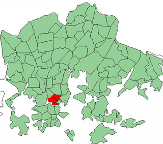
Kamppi is a neighbourhood in the centre of Helsinki, the capital of Finland. The name originally referred to a small area known as the "Kamppi field", but according to the current official designation, "Kamppi" encompasses a much larger area with a population of 10,000 in 2004.
Kallio is a district and a neighbourhood in Helsinki, the capital of Finland, located on the eastern side of the Helsinki peninsula about one kilometre north from the city centre. It is one of the most densely populated areas in Finland. Kallio is separated from the city centre by the Siltasaarensalmi strait, over which is a bridge called Pitkäsilta. Traditionally, the bridge symbolizes the divide between the affluent centre and the more working class areas around Kallio.

East Helsinki is an area in Helsinki, Finland, usually thought to comprise the city's eastern and south-eastern major districts, including the districts of Vartiokylä, Myllypuro, Mellunkylä, Vuosaari, Herttoniemi, Laajasalo and Kulosaari. With the exception of Kulosaari, the buildings in the area are relatively new – most have been built in the 1960s or later – and constitute relatively densely inhabited suburbs, except for the southern part of Laajasalo and most of Kulosaari. On the other side of the bridge to the west of Kulosaari is Helsinki Downtown, the so-called "South Helsinki". Officially, the name "East Helsinki" is not found in the city's regional nomenclature, but it was a name created by the locals of the area.
The city of Helsinki, the capital of Finland, can be divided into various sorts of subdivisions. Helsinki is divided into three major areas: Helsinki Downtown, North Helsinki and East Helsinki. The subdivisions include boroughs, districts, major districts and postal code areas. The plethora of different official ways to divide the city is a source of some confusion to the inhabitants, as different kinds of subdivisions often share similar or identical names.
Alppila is a quarter of Helsinki, Finland. It is located north of the city centre, between the districts of Kallio and Pasila, and together with Harju it forms the district of Alppiharju. Alppila has a population of 4,244 and an area of 0.60 km². The Linnanmäki amusement park and the Kulttuuritalo are located in Alppila.

Laakso is a neighbourhood in Helsinki, Finland. Its borders are defined by the streets of Mannerheimintie and Nordenskiöldinkatu and the Helsinki Central Park. The neighbourhood is bordered by Töölö in the south, Meilahti in the southwest, Ruskeasuo in the north and Länsi-Pasila in the east.

Hotel Torni is a historical hotel located in Kamppi, Helsinki, Finland, and a part of the Sokos Hotels hotel chain. When opened in 1931, it became the tallest building in Finland, a position it maintained until the completion of the new Neste headquarters in neighboring Espoo in 1976. It remained the tallest building in Helsinki until it was overtaken by Itäkeskuksen maamerkki in 1987. The interior of the building was completely renovated in 2005. It is located in central Helsinki, in the so-called Helsinki Design District.
Haaga is a district and a former municipality in the Western major district of Helsinki with a population of 25,435.

Pukinmäki is a district on the northeastern part of Helsinki, Finland. As of 2005, it had a population of 8,450.

Jakomäki is a quarter, part of Suurmetsä neighbourhood in Helsinki, Finland. It has an area of 1.92 km2 and a population of 5,481 (2005).

Talinranta is a neighbourhood in Munkkiniemi district of Helsinki, Finland. It is located west from Munkkivuori and south from Tali. In south, Finnish national road 1 separates Talinranta from Vanha Munkkiniemi.

Suutarila is a subdistrict located next to Keravanjoki in a northeastern major district of Helsinki, Finland, near the border to Vantaa

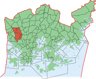
Läntinen suurpiiri is one of the seven major districts of Helsinki, Finland. It covers five subdistricts: Reijola, Munkkiniemi, Haaga, Pitäjänmäki and Kaarela. As of 2005, western major district has 98,545 inhabitants living in an area of 30.4 km2.

Highways in Finland, or Main roads, comprise the highest categories of roads in Finland:
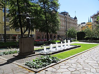
Kolmikulma, also known as the Diana Park, is a small, rectangular triangular-shaped park located in the Kaartinkaupunki district in the city center of Helsinki, Finland. It is limited by the Yrjönkatu, Uudenmaankatu and Erottajankatu streets. The park was renovated in 2006 and 2007.

