Revere, Minnesota

Last updated
Revere
Redwood County Minnesota Incorporated and Unincorporated areas Revere Highlighted.svg
Cities and townships of Redwood County
Coordinates: 44°13′18″N95°21′40″W / 44.22167°N 95.36111°W / 44.22167; -95.36111
Country United States
State Minnesota
County Redwood
Area
[1]
  Total0.57 sq mi (1.48 km2)
  Land0.57 sq mi (1.48 km2)
  Water0.00 sq mi (0.00 km2)
Elevation
[2]
1,145 ft (349 m)
Population
 (2020)
  Total89
  Density155.32/sq mi (60.01/km2)
Time zone UTC-6 (Central (CST))
  Summer (DST) UTC-5 (CDT)
ZIP code
56166
Area code 507
FIPS code 27-53908 [3]
GNIS feature ID2396355 [2]

Revere is a city in Redwood County, Minnesota, United States. The population was 95 at the 2010 census. [4]

Contents

History

Revere was platted in 1886. [5] It was named after Paul Revere, a patriot in the American Revolution. [5] Revere was organized in 1900. [6]

Geography

According to the United States Census Bureau, the city has a total area of 0.57 square miles (1.48 km2), all land. [7]

Revere is located along U.S. Highway 14 between Walnut Grove to the west and Lamberton to the east.

Demographics

Historical population
CensusPop.Note
1910 134
1920 1340.0%
1930 1469.0%
1940 19734.9%
1950 1980.5%
1960 2011.5%
1970 166−17.4%
1980 158−4.8%
1990 117−25.9%
2000 100−14.5%
2010 95−5.0%
2020 89−6.3%
U.S. Decennial Census [8]

2010 census

As of the census [9] of 2010, there were 95 people, 34 households, and 23 families living in the city. The population density was 166.7 inhabitants per square mile (64.4/km2). There were 40 housing units at an average density of 70.2 per square mile (27.1/km2). The racial makeup of the city was 91.6% White, 4.2% African American, 3.2% Native American, and 1.1% Asian. Hispanic or Latino of any race were 3.2% of the population.

There were 34 households, of which 26.5% had children under the age of 18 living with them, 50.0% were married couples living together, 5.9% had a female householder with no husband present, 11.8% had a male householder with no wife present, and 32.4% were non-families. 29.4% of all households were made up of individuals, and 8.8% had someone living alone who was 65 years of age or older. The average household size was 2.24 and the average family size was 2.78.

The median age in the city was 41.3 years. 20% of residents were under the age of 18; 11.6% were between the ages of 18 and 24; 25.3% were from 25 to 44; 30.6% were from 45 to 64; and 12.6% were 65 years of age or older. The gender makeup of the city was 53.7% male and 46.3% female.

2000 census

As of the census [3] of 2000, there were 100 people, 41 households, and 23 families living in the city. The population density was 174.0 inhabitants per square mile (67.2/km2). There were 44 housing units at an average density of 76.6 per square mile (29.6/km2). The racial makeup of the city was 98.00% White, 1.00% African American and 1.00% Native American.

There were 41 households, out of which 29.3% had children under the age of 18 living with them, 39.0% were married couples living together, 9.8% had a female householder with no husband present, and 43.9% were non-families. 41.5% of all households were made up of individuals, and 22.0% had someone living alone who was 65 years of age or older. The average household size was 2.00 and the average family size was 2.61.

In the city, the population was spread out, with 19.0% under the age of 18, 4.0% from 18 to 24, 34.0% from 25 to 44, 23.0% from 45 to 64, and 20.0% who were 65 years of age or older. The median age was 42 years. For every 100 females, there were 92.3 males. For every 100 females age 18 and over, there were 102.5 males.

The median income for a household in the city was $14,643, and the median income for a family was $21,875. Males had a median income of $31,250 versus $16,875 for females. The per capita income for the city was $14,519. There were 33.3% of families and 34.7% of the population living below the poverty line, including 42.1% of under eighteens and 14.8% of those over 64.

Related Research Articles

<span class="mw-page-title-main">Correll, Minnesota</span> City in Minnesota, United States

Correll is a city in Big Stone County, Minnesota, United States. The population was 34 at the 2010 census. Correll was named for David N Correll, a railroad official who founded the city in 1881.

<span class="mw-page-title-main">Hanska, Minnesota</span> City in Minnesota, United States

Hanska is a city in Brown County, Minnesota, United States. The population was 402 at the 2010 census.

<span class="mw-page-title-main">Chickamaw Beach, Minnesota</span> City in Minnesota, United States

Chickamaw Beach is a city in Cass County, Minnesota, United States. The population was 114 at the 2010 census. It is part of the Brainerd Micropolitan Statistical Area.

<span class="mw-page-title-main">Stacy, Minnesota</span> City in Minnesota, United States

Stacy is a city in Chisago County, Minnesota, United States, along the Sunrise River. The population was 1,456 at the 2010 census.

<span class="mw-page-title-main">New Trier, Minnesota</span> City in Minnesota, United States

New Trier is a city in Dakota County, Minnesota, United States. The population was 112 at the 2010 census. Minnesota Highway 50 serves as a main route in the community.

<span class="mw-page-title-main">Miltona, Minnesota</span> City in Minnesota, United States

Miltona is a city in Douglas County, Minnesota, United States. The population was 431 at the 2020 census.

<span class="mw-page-title-main">Nashwauk, Minnesota</span> City in Minnesota, United States

Nashwauk is a city in Itasca County, Minnesota, United States. The population was 983 at the 2010 census.

<span class="mw-page-title-main">Le Center, Minnesota</span> City in Minnesota, United States

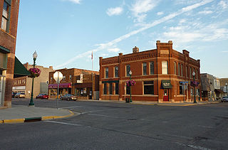
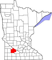
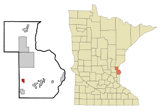
Le Center is a city in Le Sueur County, Minnesota, United States. The population was 2,517 at the 2020 census. It is the county seat of Le Sueur County. The Le Sueur County Courthouse and Jail are listed on the National Register of Historic Places.

<span class="mw-page-title-main">Harding, Minnesota</span> City in Minnesota, United States

Harding is a city in Morrison County, Minnesota, United States, along the Platte River. The population was 123 at the 2020 census.

<span class="mw-page-title-main">Sargeant, Minnesota</span> City in Minnesota, United States

Sargeant is a city in Sargeant Township, Mower County, Minnesota, United States. The population was 61 at the 2010 census.

<span class="mw-page-title-main">Shelly, Minnesota</span> City in Minnesota, United States

Shelly is a city in Norman County, Minnesota, United States. The population was 179 at the 2020 census.

<span class="mw-page-title-main">Bluffton, Minnesota</span> City in Minnesota, United States

Bluffton is a city in Otter Tail County, Minnesota, United States, along the Leaf River. The population was 210 at the 2020 census.

<span class="mw-page-title-main">Deer Creek, Minnesota</span> City in Minnesota, United States

Deer Creek is a city in Otter Tail County, Minnesota, United States. The population was 330 at the 2020 census.

<span class="mw-page-title-main">Gully, Minnesota</span> City in Minnesota, United States

Gully is a city in Polk County, Minnesota, United States. It is part of the Grand Forks-ND-MN Metropolitan Statistical Area. The population was 59 at the 2020 census.

<span class="mw-page-title-main">Lengby, Minnesota</span> City in Minnesota, United States

Lengby is a city in Polk County, Minnesota, United States. It is part of the Grand Forks ND-MN Metropolitan Statistical Area. The population was 92 at the 2020 census.

<span class="mw-page-title-main">Mentor, Minnesota</span> City in Minnesota, United States

Mentor is a city in Polk County, Minnesota, United States. It is part of the Grand Forks-ND-MN Metropolitan Statistical Area. The population was 104 at the 2020 census. The city is near Maple Lake.

<span class="mw-page-title-main">St. Martin, Minnesota</span> City in Minnesota, United States

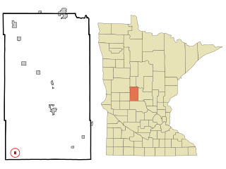
St. Martin or Saint Martin, Smartin to locals, is a city in Stearns County, Minnesota, United States. The population was 308 at the 2010 census. It is part of the St. Cloud Metropolitan Statistical Area.

<span class="mw-page-title-main">West Union, Minnesota</span> City in Minnesota, United States

West Union is a city in Todd County, Minnesota, United States. The population was 111 at the 2010 census.

<span class="mw-page-title-main">Hammond, Minnesota</span> City in Minnesota, United States

Hammond is a city in Wabasha County, Minnesota, United States. The population was 132 at the 2010 census.

<span class="mw-page-title-main">Foxhome, Minnesota</span> City in Minnesota, United States

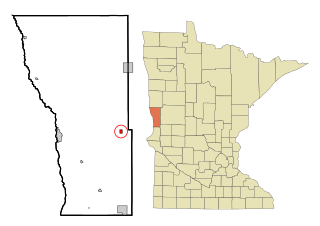
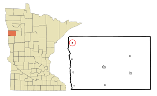
Foxhome is a city in Wilkin County, Minnesota, United States. The population was 126 at the 2020 census. It is part of the Wahpeton, ND—MN Micropolitan Statistical Area.

References

  1. "2020 U.S. Gazetteer Files". United States Census Bureau. Retrieved July 24, 2022.
  2. 1 2 U.S. Geological Survey Geographic Names Information System: Revere, Minnesota
  3. 1 2 "U.S. Census website". United States Census Bureau . Retrieved 2008-01-31.
  4. "2010 Census Redistricting Data (Public Law 94-171) Summary File". American FactFinder. United States Census Bureau . Retrieved 27 April 2011.[ dead link ]
  5. 1 2 Chicago and North Western Railway Company (1908). A History of the Origin of the Place Names Connected with the Chicago & North Western and Chicago, St. Paul, Minneapolis & Omaha Railways. p. 117.
  6. Upham, Warren (1920). Minnesota Geographic Names: Their Origin and Historic Significance. Minnesota Historical Society. p.  451.
  7. "US Gazetteer files 2010". United States Census Bureau. Archived from the original on 2012-01-25. Retrieved 2012-11-13.
  8. "Census of Population and Housing". Census.gov. Retrieved June 4, 2015.
  9. "U.S. Census website". United States Census Bureau . Retrieved 2012-11-13.