Seaforth, Minnesota

Last updated
Seaforth
Redwood County Minnesota Incorporated and Unincorporated areas Seaforth Highlighted.svg
Cities and townships of Redwood County
Coordinates: 44°28′37″N95°19′43″W / 44.47694°N 95.32861°W / 44.47694; -95.32861
Country United States
State Minnesota
County Redwood
Area
[1]
  Total1.02 sq mi (2.65 km2)
  Land1.02 sq mi (2.64 km2)
  Water0.01 sq mi (0.02 km2)
Elevation
[2]
1,053 ft (321 m)
Population
 (2020)
  Total82
  Density80.63/sq mi (31.12/km2)
Time zone UTC-6 (Central (CST))
  Summer (DST) UTC-5 (CDT)
ZIP code
56287
Area code 507
FIPS code 27-59098 [3]
GNIS feature ID2396564 [2]

Seaforth is a town in Redwood County, Minnesota, United States. The population was 86 at the 2010 census. [4]

Contents

History

Seaforth was originally called Okawa, and under the latter name was platted in 1894. [5] The present name is after Loch Seaforth, in Scotland. [5] Seaforth was incorporated in 1900. [6] A post office called Seaforth was established in 1899, and remained in operation until it was discontinued in 1995. [7]

Geography

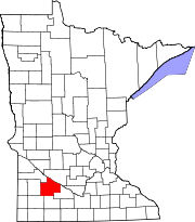
Location of Seaforth, Minnesota MNMap-doton-Seaforth.png
Location of Seaforth, Minnesota

According to the United States Census Bureau, the city has a total area of 1.01 square miles (2.62 km2); 1.00 square mile (2.59 km2) is land and 0.01 square miles (0.03 km2) is water. [8] The Redwood River flows through the northeastern corner of the city. [9]

Seaforth is located along County Highway 7, which runs between Minnesota State Highways 19 and 67 to the north and 68 to the south. [9]

Demographics

Historical population
CensusPop.Note
1910 158
1920 113−28.5%
1930 1249.7%
1940 14819.4%
1950 136−8.1%
1960 131−3.7%
1970 1320.8%
1980 90−31.8%
1990 87−3.3%
2000 77−11.5%
2010 8611.7%
2020 82−4.7%
U.S. Decennial Census [10]

2010 census

As of the census [11] of 2010, there were 86 people, 35 households, and 20 families living in the city. The population density was 86.0 inhabitants per square mile (33.2/km2). There were 38 housing units at an average density of 38.0 per square mile (14.7/km2). The racial makeup of the city was 100.0% White. Hispanic or Latino of any race were 2.3% of the population.

There were 35 households, of which 34.3% had children under the age of 18 living with them, 51.4% were married couples living together, 5.7% had a female householder with no husband present, and 42.9% were non-families. 37.1% of all households were made up of individuals, and 11.5% had someone living alone who was 65 years of age or older. The average household size was 2.46 and the average family size was 3.45.

The median age in the city was 36.5 years. 30.2% of residents were under the age of 18; 3.6% were between the ages of 18 and 24; 25.6% were from 25 to 44; 26.8% were from 45 to 64; and 14% were 65 years of age or older. The gender makeup of the city was 55.8% male and 44.2% female.

2000 census

As of the census [3] of 2000, there were 77 people, 37 households, and 20 families living in the city. The population density was 76.3 inhabitants per square mile (29.5/km2). There were 41 housing units at an average density of 40.6 per square mile (15.7/km2). The racial makeup of the city was 100.00% White.

There were 37 households, out of which 18.9% had children under the age of 18 living with them, 45.9% were married couples living together, 8.1% had a female householder with no husband present, and 45.9% were non-families. 40.5% of all households were made up of individuals, and 13.5% had someone living alone who was 65 years of age or older. The average household size was 2.08 and the average family size was 2.90.

In the city, the population was spread out, with 22.1% under the age of 18, 1.3% from 18 to 24, 24.7% from 25 to 44, 28.6% from 45 to 64, and 23.4% who were 65 years of age or older. The median age was 46 years. For every 100 females, there were 92.5 males. For every 100 females age 18 and over, there were 87.5 males.

The median income for a household in the city was $27,143, and the median income for a family was $26,875. Males had a median income of $29,375 versus $22,500 for females. The per capita income for the city was $15,089. There were 9.5% of families and 9.4% of the population living below the poverty line, including 66.7% of under eighteens and none of those over 64.

Related Research Articles

North Star Township is a township in Brown County, Minnesota, United States. The population was 325 as of the 2000 census.

<span class="mw-page-title-main">Russell, Minnesota</span> City in Minnesota, United States

Russell is a city in Lyon County, Minnesota, United States. The population was 338 at the 2010 census.

<span class="mw-page-title-main">Bluffton, Minnesota</span> City in Minnesota, United States

Bluffton is a city in Otter Tail County, Minnesota, United States, along the Leaf River. The population was 210 at the 2020 census.

<span class="mw-page-title-main">Belview, Minnesota</span> City in Minnesota, United States

Belview is a city in Redwood County, Minnesota, United States. The population was 384 at the 2010 census.

<span class="mw-page-title-main">Clements, Minnesota</span> City in Minnesota, United States

Clements is a city in Redwood County, Minnesota, United States. The population was 153 at the 2010 census.

<span class="mw-page-title-main">Delhi, Minnesota</span> City in Minnesota, United States

Delhi is a city in Redwood County, Minnesota, United States. The population was 70 at the 2010 census.

<span class="mw-page-title-main">Granite Rock Township, Redwood County, Minnesota</span> Township in Minnesota, United States

Granite Rock Township is one of the twenty-six townships of Redwood County, Minnesota, United States. The population was 241 at the 2000 census.

<span class="mw-page-title-main">Honner Township, Redwood County, Minnesota</span> Township in Minnesota, United States

Honner Township was previously one of the twenty-six townships of Redwood County, Minnesota, United States. The population was 86 at the 2000 census.

<span class="mw-page-title-main">Lamberton, Minnesota</span> City in Minnesota, United States

Lamberton is a town in Redwood County, Minnesota, United States. The population was 824 at the 2010 census.

<span class="mw-page-title-main">Lucan, Minnesota</span> City in Minnesota, United States

Lucan is a city in Redwood County, Minnesota, United States. The population was 191 at the 2010 census.

<span class="mw-page-title-main">Milroy, Minnesota</span> City in Minnesota, United States

Milroy is a city in Redwood County, Minnesota, United States. The population was 252 at the 2010 census. It is named after Robert H. Milroy, a Union Army general in the American Civil War.

<span class="mw-page-title-main">Morgan, Minnesota</span> City in Minnesota, United States

Morgan is a city in Redwood County, Minnesota, United States. The population was 896 at the 2010 census.

<span class="mw-page-title-main">Redwood Falls Township, Redwood County, Minnesota</span> Township in Minnesota, United States

Redwood Falls Township is one of the twenty-six townships of Redwood County, Minnesota, United States. The population was 256 at the 2000 census.

<span class="mw-page-title-main">Revere, Minnesota</span> City in Minnesota, United States

Revere is a city in Redwood County, Minnesota, United States. The population was 95 at the 2010 census.

<span class="mw-page-title-main">Sheridan Township, Redwood County, Minnesota</span> Township in Minnesota, United States

Sheridan Township is one of the twenty-six townships of Redwood County, Minnesota, United States. The population was 253 at the 2000 census.

<span class="mw-page-title-main">Vesta, Minnesota</span> City in Minnesota, United States

Vesta is a city in Redwood County, Minnesota, United States. The population was 319 at the 2010 census.

<span class="mw-page-title-main">Wabasso, Minnesota</span> City in Minnesota, United States

Wabasso is a city in Redwood County, Minnesota, United States. The population was 696 at the 2010 census.

<span class="mw-page-title-main">Wanda, Minnesota</span> City in Minnesota, United States

Wanda is a city in Redwood County, Minnesota, United States. The population was 84 at the 2010 census.

<span class="mw-page-title-main">Lake Henry, Minnesota</span> City in Minnesota, United States

Lake Henry is a city in Stearns County, Minnesota, United States. The population was 103 at the 2010 census. It is part of the St. Cloud Metropolitan Statistical Area.

Burnstown Township is a township in Brown County, Minnesota, United States. The population was 260 as of the 2000 census.

References

  1. "2020 U.S. Gazetteer Files". United States Census Bureau. Retrieved July 24, 2022.
  2. 1 2 U.S. Geological Survey Geographic Names Information System: Seaforth, Minnesota
  3. 1 2 "U.S. Census website". United States Census Bureau . Retrieved 2008-01-31.
  4. "2010 Census Redistricting Data (Public Law 94-171) Summary File". American FactFinder. United States Census Bureau . Retrieved 27 April 2011.[ dead link ]
  5. 1 2 Chicago and North Western Railway Company (1908). A History of the Origin of the Place Names Connected with the Chicago & North Western and Chicago, St. Paul, Minneapolis & Omaha Railways. p. 123.
  6. Upham, Warren (1920). Minnesota Geographic Names: Their Origin and Historic Significance. Minnesota Historical Society. p.  452.
  7. "Redwood County". Jim Forte Postal History. Retrieved 28 March 2015.
  8. "US Gazetteer files 2010". United States Census Bureau. Archived from the original on 2012-01-25. Retrieved 2012-11-13.
  9. 1 2 Minnesota Atlas & Gazetteer. Yarmouth, Me.: DeLorme. 1994. p. 30. ISBN   0-89933-222-6.
  10. "Census of Population and Housing". Census.gov. Retrieved June 4, 2015.
  11. "U.S. Census website". United States Census Bureau . Retrieved 2012-11-13.