Rexburg, Idaho micropolitan area

Last updated
Location of the Rexburg Micropolitan Statistical Area in Idaho Rexburg Micropolitan Area.png
Location of the Rexburg Micropolitan Statistical Area in Idaho

The Rexburg Micropolitan Statistical Area, as defined by the United States Census Bureau, is an area consisting of two counties in eastern Idaho, anchored by the city of Rexburg.

United States Census Bureau Bureau of the United States responsible for the census and related statistics

The United States Census Bureau is a principal agency of the U.S. Federal Statistical System, responsible for producing data about the American people and economy. The Census Bureau is part of the U.S. Department of Commerce and its director is appointed by the President of the United States.

Eastern Idaho

Eastern Idaho is the area of Idaho lying east of the Magic Valley region. It is generally understood to include: Bannock, Bear Lake, Bingham, Bonneville, Butte, Caribou, Clark, Custer, Franklin, Fremont, Jefferson, Madison, Oneida, Power and Teton Counties. In terms of culture much of the region is in the Mormon Corridor and The Church of Jesus Christ of Latter-day Saints plays a major role in the lives of a majority of the region's residents.

Idaho State of the United States of America

Idaho is a state in the northwestern region of the United States. It borders the state of Montana to the east and northeast, Wyoming to the east, Nevada and Utah to the south, and Washington and Oregon to the west. To the north, it shares a small portion of the Canadian border with the province of British Columbia. With a population of approximately 1.7 million and an area of 83,569 square miles (216,440 km2), Idaho is the 14th largest, the 12th least populous and the 7th least densely populated of the 50 U.S. states. The state's capital and largest city is Boise.

Contents

As of the 2000 census, the μSA had a population of 39,286 (though a July 1, 2007 estimate placed the population at 49,164). [1]

Counties

Communities

Rexburg, Idaho City in Idaho, United States

Rexburg is a city in Madison County, Idaho, United States. The population was 25,484 at the 2010 census, up from 17,257 in 2000. The city is the county seat of Madison County and its largest city. Rexburg is the principal city of the Rexburg, ID Micropolitan Statistical Area, which includes Fremont and Madison Counties. The city is home to Brigham Young University-Idaho (BYU-Idaho), a private institution operated by The Church of Jesus Christ of Latter-day Saints.

Ashton, Idaho City in Idaho, United States

Ashton is a city in Fremont County, Idaho, United States. The population was 1,127 at the 2010 census, and it is part of the Rexburg Micropolitan Statistical Area. The district is noted for seed potato production and bills itself as the world's largest seed potato growing area.

Drummond, Idaho City in Idaho, United States

Drummond is a city in Fremont County, Idaho, United States. The population was 16 at the 2010 census. It is part of the Rexburg, Idaho Micropolitan Statistical Area.

Demographics

As of the census [2] of 2000, there were 39,286 people, 11,014 households, and 7,884 families residing within the μSA. The racial makeup of the μSA was 94.27% White, 0.21% African American, 0.38% Native American, 0.51% Asian, 0.15% Pacific Islander, 3.35% from other races, and 1.14% from two or more races. Hispanic or Latino of any race were 5.94% of the population.

Census Acquiring and recording information about the members of a given population

A census is the procedure of systematically acquiring and recording information about the members of a given population. The term is used mostly in connection with national population and housing censuses; other common censuses include agriculture, business, and traffic censuses. The United Nations defines the essential features of population and housing censuses as "individual enumeration, universality within a defined territory, simultaneity and defined periodicity", and recommends that population censuses be taken at least every 10 years. United Nations recommendations also cover census topics to be collected, official definitions, classifications and other useful information to co-ordinate international practice.

The median income for a household in the μSA was $33,016, and the median income for a family was $38,798. Males had a median income of $27,895 versus $19,149 for females. The per capita income for the μSA was $12,461.

Per capita income mean income of the people in an economic unit such as a country or city

Per capita income (PCI) or average income measures the average income earned per person in a given area in a specified year. It is calculated by dividing the area's total income by its total population.

See also

Related Research Articles

Tupelo micropolitan area Micropolitan area in Mississippi, United States

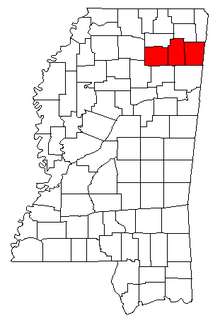
The Tupelo Micropolitan Statistical Area is a micropolitan area in northeastern Mississippi that covers three counties - Itawamba, Lee and Pontotoc. As of the 2000 census, the μSA had a population of 125,251.

Scottsbluff Micropolitan Statistical Area

The Scottsbluff Micropolitan Statistical Area, as defined by the United States Census Bureau, is an area consisting of two counties in Nebraska, anchored by the city of Scottsbluff.

North Platte Micropolitan Statistical Area

The North Platte Micropolitan Statistical Area, as defined by the United States Census Bureau, is an area consisting of three counties in Nebraska, anchored by the city of North Platte. As of the 2000 census, the area had a population of 35,939.

Idaho Falls metropolitan area human settlement in Idaho, United States of America

The Idaho Falls Metropolitan Statistical Area, as defined by the United States Census Bureau, is an area consisting of two counties in eastern Idaho, anchored by the city of Idaho Falls. As of the 2010 census, the MSA had a population of 130,374.

Burley, Idaho micropolitan area Place

The Burley Micropolitan Statistical Area, as defined by the United States Census Bureau, is an area consisting of two counties in the Magic Valley region of Idaho, anchored by the city of Burley. It is commonly referred to locally as the "Mini-Cassia" area, an amalgam of Minidoka and Cassia Counties.

The Ontario Micropolitan Statistical Area, as defined by the United States Census Bureau, is an area consisting of two counties – one in southeastern Oregon and one in southwestern Idaho, anchored by the city of Ontario.

The Jackson Micropolitan Statistical Area, as defined by the United States Census Bureau, is an area consisting of two counties, one in Wyoming and one in Idaho, anchored by the town of Jackson.

New Bern Metropolitan Statistical Area

The New Bern Metropolitan Statistical Area, as defined by the United States Census Bureau, is an area consisting of three counties in the Inner Banks region of eastern North Carolina, anchored by the city of New Bern. The designation of the area was changed from Micropolitan to Metropolitan in 2013.

Frankfort, Kentucky micropolitan area

The Frankfort Micropolitan Statistical Area, as defined by the United States Census Bureau, is an area consisting of two counties in central Kentucky, anchored by the city of Frankfort. As of the 2000 census, the Micropolitan Statistical Area (μSA) had a population of 66,798.

Richmond–Berea micropolitan area

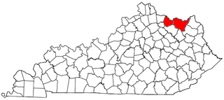
The Richmond–Berea Micropolitan Statistical Area, as defined by the United States Census Bureau, is an area consisting of two counties in Kentucky, anchored by the cities of Richmond and Berea. As of the 2000 census, the μSA had a population of 87,454.

Glasgow, Kentucky, micropolitan area

The Glasgow Micropolitan Statistical Area, as defined by the United States Census Bureau, is an area consisting of two counties in Kentucky, anchored by the city of Glasgow. As of the 2000 census, the μSA had a population of 48,070.

Danville, Kentucky micropolitan area

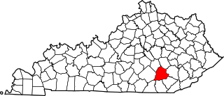
The Danville Micropolitan Statistical Area, as defined by the United States Census Bureau, is an area consisting of Boyle and Lincoln counties in Kentucky, anchored by the city of Danville. As of the 2000 census, the μSA had a population of 51,058. A July 1, 2009 estimate placed the population at 54,435.

Maysville, Kentucky micropolitan area

The Maysville Micropolitan Statistical Area (μSA), as defined by the United States Census Bureau, is coterminous with Mason County, Kentucky, whose county seat and largest city is Maysville. As of the 2010 census, the population of Mason County and the current µSA was 17,490, and 2014 Census Bureau estimates place the population at 17,166.

Hannibal, Missouri micropolitan area

The Hannibal Micropolitan Statistical Area, as defined by the United States Census Bureau, is an area consisting of two counties in northeast Missouri, anchored by the city of Hannibal.

Alexander City micropolitan area

The Alexander City Micropolitan Statistical Area is a former micropolitan statistical area that consisted of two counties in Alabama, anchored by the city of Alexander City, as defined by the United States Census Bureau. As of the 2010 census, the μSA had a population of 53,155.

Waycross, Georgia micropolitan area

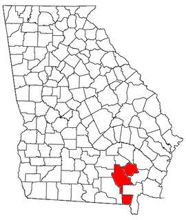
The Waycross Micropolitan Statistical Area (μSA), as defined by the United States Census Bureau, is an area consisting of two counties in Georgia, anchored by the city of Waycross.

Martinsville, Virginia micropolitan area

The Martinsville Micropolitan Statistical Area is a United States Micropolitan Statistical Area (μSA) in Virginia, as defined by the Office of Management and Budget (OMB) as of June, 2003. As of the 2000 census, the μSA had a population of 73,346.

Jasper, Indiana, micropolitan area Micropolitan area in Indiana, United States

The Jasper micropolitan statistical area, as defined by the United States Census Bureau, is an area consisting of two counties in southwestern Indiana, anchored by the city of Jasper. At the 2010 census, the Micropolitan area (μSA) had a population of 54,734 up from a population of 52,511 in the 2000 census. The micropolitan area covers an area of 776 sq mi (2,010 km2).

Corbin, KY Micropolitan Statistical Area

The Corbin Micropolitan Statistical Area, as defined by the United States Census Bureau, is an area consisting of Whitley County, Kentucky, anchored by the Whitley County portion of the city of Corbin. As of the 2000 census, the μSA had a population of 35,865.

London, KY Micropolitan Statistical Area

The London, KY Micropolitan Statistical Area is a United States Census Bureau defined Micropolitan Statistical Area located in the vicinity of London, Kentucky. The London Micropolitan Statistical Area encompasses Laurel County entirely. The Micropolitan Statistical Area had a population of 52,715 at the 2000 Census. A July 1, 2009 U.S. Census Bureau estimate placed the population at 57,749.

References