Inland Northwest (United States)

Last updated
Map of the Inland Northwest. Counties highlighted in red are always included, while counties in pink are sometimes included. Inland Northwest.svg
Map of the Inland Northwest. Counties highlighted in red are always included, while counties in pink are sometimes included.

The Inland Northwest [1] or Inland Empire is a region adjacent to and just east of the Pacific Northwest centered on the Greater Spokane Area, that includes all of Eastern Washington and all of North Idaho. The region also contains the Tri-Cities. The portion of Montana west of the Continental Divide is sometimes included as part of the region. Included in the region are the counties of:

Pacific Northwest Region that includes parts of Canada and the United States

The Pacific Northwest (PNW), sometimes referred to as Cascadia, is a geographic region in western North America bounded by the Pacific Ocean to the west and (loosely) by the Cascade Mountain Range on the east. Though no official boundary exists, the most common conception includes the Canadian province of British Columbia (BC) and the U.S. states of Idaho, Oregon, and Washington. Broader conceptions reach north into Southeast Alaska and Yukon, south into northern California, and east to the Continental Divide to include Western Montana and parts of Wyoming. Narrower conceptions may be limited to the coastal areas west of the Cascade and Coast mountains. The variety of definitions can be attributed to partially overlapping commonalities of the region's history, culture, geography, society, and other factors.

Eastern Washington Metropolitan area in Washington, United States

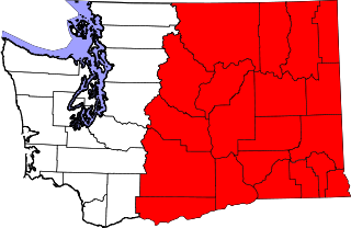
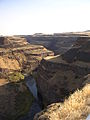
Eastern Washington is the portion of the US state of Washington east of the Cascade Range. The region contains the city of Spokane, the Tri-Cities, the Columbia River and the Grand Coulee Dam, the Hanford Nuclear Reservation and the fertile farmlands of the Yakima Valley and the Palouse. Unlike in Western Washington, the climate is dry, including some desert environments.

Tri-Cities, Washington Place in Washington

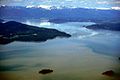
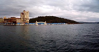
The Tri-Cities are three closely tied cities – Kennewick, Pasco, and Richland – located at the confluence of the Yakima, Snake, and Columbia Rivers in the Columbia Basin of Eastern Washington. Each city borders one-another, making the Tri-Cities seem like one uninterrupted mid-sized city. The three cities function as the center of the Tri-Cities metropolitan area, which consists of Franklin and Benton Counties. The Tri-Cities urban area consists of the city of West Richland, the CDPs of West Pasco and Finley, as well as the CDP of Burbank, despite the latter being located in the Walla Walla metropolitan area.

Contents

Washington
Adams, Asotin, Benton, Chelan, Columbia, Douglas, Ferry, Franklin, Garfield, Grant, Kittitas, Klickitat, Lincoln, Okanogan, Pend Oreille, Spokane, Stevens, Walla Walla, Whitman, and Yakima
Idaho
Benewah, Bonner, Boundary, Clearwater, Idaho, Kootenai, Latah, Lewis, Nez Perce, and Shoshone

Montana (sometimes included)

Flathead, Lake, Lincoln, Mineral, Missoula, Ravalli, and Sanders

As of 2016 the U.S. Census Bureau estimated the region's population at 2,240,645, comparable to that of New Mexico. Its Canadian counterpart, north of the border, is the British Columbia Interior.

New Mexico State of the United States of America

New Mexico is a state in the Southwestern region of the United States of America; its capital and cultural center is Santa Fe, which was founded in 1610 as capital of Nuevo México, while its largest city is Albuquerque with its accompanying metropolitan area. It is one of the Mountain States and shares the Four Corners region with Utah, Colorado, and Arizona; its other neighboring states are Oklahoma to the northeast, Texas to the east-southeast, and the Mexican states of Chihuahua to the south and Sonora to the southwest. With a population around two million, New Mexico is the 36th state by population. With a total area of 121,592 sq mi (314,920 km2), it is the fifth-largest and sixth-least densely populated of the 50 states. Due to their geographic locations, northern and eastern New Mexico exhibit a colder, alpine climate, while western and southern New Mexico exhibit a warmer, arid climate.

The British Columbia Interior, BC Interior or Interior of British Columbia, usually referred to only as the Interior, is one of the three main regions of the Canadian province of British Columbia, the other two being the Lower Mainland, which comprises the overlapping areas of Greater Vancouver and the Fraser Valley, and the Coast, which includes Vancouver Island and also including the Lower Mainland.

Geography

The region is bounded by the Cascade Mountains on the west and the Rocky Mountains (following the spine of the remote and rugged Cabinet Mountains) on the east, the Blue Mountains of Oregon and foothills of the Wallowa Mountains to the south, southeast, and encompasses the Columbia river basin (or Columbia Plateau). Between the three mountain ranges are large, sweeping areas of semi-arid steppe, part of which has been irrigated due to the Columbia Basin Project, resulting in expansive farmland in central Washington. The Palouse, original home of the Appaloosa, is another major agricultural region located in the gently rolling hills of southeastern Washington and extending into Idaho. In northern Idaho, the Silver Valley is a mineral-rich region of the Coeur d'Alene Mountains noted for its mining heritage, dating back to the 1880s.

Rocky Mountains mountain range in North America

The Rocky Mountains, also known as the Rockies, are a major mountain range in western North America. The Rocky Mountains stretch more than 4,800 kilometers (3,000 mi) from the northernmost part of British Columbia, in western Canada, to New Mexico in the Southwestern United States. Located within the North American Cordillera, the Rockies are somewhat distinct from the Pacific Coast Ranges, Cascade Range, and the Sierra Nevada, which all lie farther to the west.

Cabinet Mountains mountain range in Montana and Idaho, United States

The Cabinet Mountains are part of the Rocky Mountains, located in northwest Montana and the Idaho panhandle, in the United States. The mountains cover an area of 2,134 square miles (5,527 km²). The Cabinet Mountains lie south of the Purcell Mountains, between the Kootenai River and Clark Fork River and Idaho's Lake Pend Oreille. The Cabinet Mountains lie to the east of the Purcell Trench. The Cabinet Mountains form the north side of the Clark Fork River valley in Idaho and Montana. The Cabinet Mountains Wilderness is located east of the Bull River near Noxon, Montana in roughly the center of the range.

Wallowa Mountains mountain range

The Wallowa Mountains are a mountain range located in the Columbia Plateau of northeastern Oregon in the United States. The range runs approximately 40 miles (64 km) northwest to southeast in southwestern Wallowa County and eastern Union County between the Blue Mountains to the west and the Snake River to the east. The range is sometimes considered to be an eastern spur of the Blue Mountains, and it is known as the "Alps of Oregon". Much of the range is designated as the Eagle Cap Wilderness, part of the Wallowa–Whitman National Forest.

Spokane is the region's largest city, is located near where the arid, and largely unforested Columbia plateau meets the lush forests of the Selkirk Mountains. The urban area stretches east into Idaho along the I-90 corridor through the Spokane River valley across the border of Idaho to Post Falls and the city of Coeur d'Alene on the north bank of Lake Coeur d'Alene. The Northeastern Washington and Northern Idaho portion of the Inland Empire are mountainous and forested, and the crest of the Bitterroot Range of the Rocky Mountains forms part of the eastern boundary of the Inland Empire region, while the Columbia River forms a significant part of its southern boundary.

Selkirk Mountains mountain range

The Selkirk Mountains are a mountain range spanning the northern portion of the Idaho Panhandle, eastern Washington, and southeastern British Columbia which are part of a larger grouping of mountains, the Columbia Mountains. They begin at Mica Peak near Spokane and extend approximately 320 km north from the border to Kinbasket Lake, at the now-inundated location of the onetime fur company post Boat Encampment. The range is bounded on its west, northeast and at its northern extremity by the Columbia River, or the reservoir lakes now filling most of that river's course. From the Columbia's confluence with the Beaver River, they are bounded on their east by the Purcell Trench, which contains the Beaver River, Duncan River, Duncan Lake, Kootenay Lake and the Kootenay River. The Selkirks are distinct from, and geologically older than, the Rocky Mountains. The neighboring Monashee and Purcell Mountains, and sometimes including the Cariboo Mountains to the northwest, are also part of the larger grouping of mountains known as the Columbia Mountains. A scenic highway loop, the International Selkirk Loop, encircles the southern portions of the mountain range.

Spokane River river in Idaho and Washington State, USA

The Spokane River is a tributary of the Columbia River, approximately 111 miles (179 km) long, in northern Idaho and eastern Washington in the United States. It drains a low mountainous area east of the Columbia, passing through the Spokane Valley and the city of Spokane, Washington.

Post Falls, Idaho City in Idaho, United States

Post Falls is a city in Kootenai County, Idaho, between Coeur d'Alene and Spokane, Washington. It is a suburb of Coeur d'Alene, to the east, and a bedroom community to Spokane, to the west. The population was 27,574 at the 2010 census, up from 17,247 in 2000 census, making it Idaho's tenth largest city. The U.S. Census Bureau estimated 2014 population is 30,123. Post Falls is also home to the last remaining 7-Eleven store in Idaho.

West Richland, Washington City in Washington, United States

West Richland is a 22-square-mile (57 km2) city in Benton County, Washington, United States. The population was 11,811 at the 2010 census. The city is located within the Tri-Cities metropolitan area, which is centered around the cities of Richland, Kennewick, and Pasco.

Coeur dAlene, Idaho City in Idaho, United States

Coeur d'Alene is the largest city and county seat of Kootenai County, Idaho, United States. It is the principal city of the Coeur d'Alene Metropolitan Statistical Area. As of the 2010 census, the population of Coeur d'Alene was 44,137. The city is a satellite city of Spokane, which is located about 30 miles (48 km) to the west, in the state of Washington. The two cities are the key components of the Spokane–Coeur d'Alene combined statistical area, of which Coeur d'Alene is the third-largest city. Coeur d'Alene is the largest city in North Idaho. The city is situated on the north shore of Lake Coeur d'Alene, 25 miles (40 km) in length. Locally, Coeur d'Alene is known as the "Lake City", or simply called by its initials: "CDA".

Latah Creek river in the United States of America

Latah Creek, officially known as Hangman Creek, is a large stream in eastern Washington and north central Idaho in the United States. The creek flows northwest from the Rocky Mountains to Spokane, where it empties into the Spokane River. It drains 673 square miles (1,740 km2) in parts of Benewah and Kootenai counties in Idaho, Spokane County and a small portion of Whitman County in Washington, where over 64 percent of its watershed resides. Some major tributaries of the approximately 60-mile (97 km) creek include Little Latah Creek and Rock Creek. The average flow of the creek can range from 20 cubic feet per second (0.57 m3/s) to 20,000 cubic feet per second (570 m3/s). Latah Creek receives its name from a Nez Perce word likely meaning "fish". In 1854, the creek received another name, Hangman Creek, from a war between the Palouse Indians and white soldiers, which resulted in several Palouse being hanged alongside the creek.

Climate

The Washington side is generally semi-arid, while the Idaho side experiences mostly a humid continental climate.

Semi-arid climate climat with precipitation below potential evapotranspiration

A semi-arid climate or steppe climate is the climate of a region that receives precipitation below potential evapotranspiration, but not as low as a desert climate. There are different kinds of semi-arid climates, depending on variables such as temperature, and they give rise to different biomes.

Idaho Panhandle

The Idaho Panhandle—locally known as North Idaho—is a region in the U.S. state of Idaho encompassing the state's 10 northernmost counties: Benewah, Bonner, Boundary, Clearwater, Idaho, Kootenai, Latah, Lewis, Nez Perce, and Shoshone. The Panhandle is bordered by the state of Washington to the west, Montana to the east, and the Canadian province of British Columbia to the north. The Idaho panhandle, along with Eastern Washington, comprises the region known as the Inland Northwest. Coeur d'Alene is the largest city within the Idaho Panhandle. Spokane, Washington is around 30 miles (48 km) west of Coeur d'Alene, and is also the location of the regional airport, Spokane International Airport. Other important cities in the region include Lewiston, Moscow, Post Falls, Hayden, Sandpoint, and the smaller towns of St. Maries and Bonners Ferry. East of Coeur d'Alene is the Silver Valley, which follows Interstate 90 to the Montana border at Lookout Pass.

Humid continental climate Category in the Köppen climate classification system

A humid continental climate is a climatic region defined by Russo-German climatologist Wladimir Köppen in 1900, typified by large seasonal temperature differences, with warm to hot summers and cold winters. Precipitation is usually distributed throughout the year. The definition of this climate regarding temperature is as follows: the mean temperature of the coldest month must be below −3 °C (26.6 °F) and there must be at least four months whose mean temperatures are at or above 10 °C (50 °F). In addition, the location in question must not be semi-arid or arid. The Dfb, Dwb and Dsb subtypes are also known as hemiboreal.

Largest cities by population

See also

Related Research Articles

Palouse region of Northwestern United States

The Palouse is a distinct geographic region of the northwestern United States, encompassing parts of north central Idaho, southeastern Washington, and, by some definitions, parts of northeast Oregon. It is a major agricultural area, primarily producing wheat and legumes. Situated about 160 miles (260 km) north of the Oregon Trail, the region experienced rapid growth in the late 19th century and was once Washington's most populous region, surpassing even the Puget Sound area.

Coeur dAlene people ethnic group

The Coeur d'Alene are a Native American nation and one of five federally recognized tribes in the state of Idaho.

North Central Idaho

North Central Idaho is an area which spans the central part of the state of Idaho and borders Oregon, Montana, and Washington. It is the southern half of the Idaho Panhandle region and is rich in agriculture and natural resources. Lewis and Clark travelled through this area on their journey to the Pacific Ocean in 1805-06. The primary cities in this region are Lewiston and Moscow, home of the University of Idaho.

Palus people Native American group of Northwestern USA

The Palus are a Sahaptin tribe recognized in the Treaty of 1855 with the United States along with the Yakama. It was negotiated at the 1855 Walla Walla Council. A variant spelling is Palouse, which was the source of the name for the fertile prairie of Washington and Idaho. Today they are enrolled in the federally recognized Confederated Tribes and Bands of the Yakama Nation and some are also represented by the Colville Confederated Tribes.

Lake Pend Oreille lake in Idaho, United States of America

Lake Pend Oreille in the northern Idaho Panhandle is the largest lake in the U.S. state of Idaho and the 38th-largest lake by area in the United States, with a surface area of 148 square miles (380 km2). It is 43 miles (69 km) long, and 1,150 feet (350 m) deep in some regions, making it the fifth-deepest in the nation. The lake is fed by the Clark Fork River and the Pack River, and drains into the Pend Oreille River, as well as subsurfacely into the Spokane Valley–Rathdrum Prairie Aquifer. It is surrounded by national forests and a few small towns, with the largest population on the lake at Sandpoint. The majority of the shoreline is non-populated and all but the southern tip of the lake is in Bonner County. The southern tip is in Kootenai County and is home to Farragut State Park, formerly the Farragut Naval Training Station during World War II, of which a small part is still active and conducts U.S. Navy acoustic underwater submarine research.

Kaniksu National Forest

The Kaniksu National Forest is a U.S. National Forest located in northeastern Washington, the Idaho panhandle, and northwestern Montana. It is one of three forests that are aggregated into the Idaho Panhandle National Forests, along with the Coeur d'Alene National Forest and St. Joe National Forest. Kaniksu National Forest has a total area of 1,627,833 acres (6,587.6 km2). About 55.7% is in Idaho, 27.9% in Montana, and 16.4% in Washington.

Battle of Four Lakes

The Battle of Four Lakes was a battle during the Coeur d'Alene War of 1858 in the Washington Territory in the United States. The Coeur d'Alene War was part of the Yakima War, which began in 1855. The battle was fought near present-day Four Lakes, Washington, between elements of the United States Army and a coalition of Native American tribes consisting of Schitsu'umsh, Palus, Spokan, and Yakama warriors.

Mullan Road

Mullan Road was the first wagon road to cross the Rocky Mountains to the Inland of the Pacific Northwest. It was built by U.S. Army troops under the command of Lt. John Mullan, between the spring of 1859 and summer 1860. It led from Fort Benton, which at the time was in the Dakota Territory, then Idaho Territory from July 1863, and Montana Territory beginning in May 1864, and the navigational head of the Missouri River. The road connected to Fort Walla Walla, Washington Territory, near the Columbia River. The road previewed the route approximately followed of modern-day Interstate 15 and Interstate 90 through present-day Montana, Idaho, and Washington.

Coeur dAlene War

The Coeur d'Alene War of 1858, also known as the Spokane-Coeur d'Alene-Pend d'oreille-Paloos War, was the second phase of the Yakima War, involving a series of encounters between the allied Native American tribes of the Skitswish, Kalispell ("Pend'Oreille"), Spokane, Palouse and Northern Paiute against United States Army forces in Washington and Idaho.

History of Spokane, Washington

The history of Spokane, Washington in the northwestern United States developed because Spokane Falls and its surroundings were a gathering place for numerous cultures for thousands of years. The area's indigenous people settled there due to the fertile hunting grounds and abundance of salmon in the Spokane River. The first European to explore the Inland Northwest was Canadian explorer-geographer David Thompson, working as head of the North West Company's Columbia Department. At the nexus of the Little Spokane and the Spokane, Thompson's men built a new fur trading post, which is the first long-term European settlement in Washington state.

Battle of Pine Creek

The Battle of Pine Creek, also known as the Battle of Tohotonimme and the Steptoe Disaster, was a conflict between United States Army forces under Brevet Lieutenant Colonel Edward Steptoe and members of the Coeur d'Alene, Palus and Spokane Native American tribes. It took place on May 17, 1858 near what is present-day Rosalia, Washington. The Native Americans were victorious.

Fort Taylor was a temporary Army post during 1858 in Washington Territory, on a site in present day Columbia County, eastern Washington state.

Battle of Spokane Plains

The Battle of Spokane Plains was a battle during the Coeur d'Alene War of 1858 in the Washington Territory in the United States. The Coeur d'Alene War was part of the Yakima War, which began in 1855. The battle was fought west of Fort George Wright near Spokane, Washington, between elements of the United States Army and a coalition of Native American tribes consisting of Kalispel, Palus, Schitsu'umsh, Spokan, and Yakama warriors.

Spokane and Inland Empire Railroad

The Spokane and Inland Empire Railroad Company (S.&I.E.R.R.Co.) was an electrified interurban railway operating in Spokane, Washington and vicinity, extending into northern and central Idaho. The system originated in several predecessor roads beginning c. 1890, incorporated in 1904, and ran under its own name to 1929. It merged into the Great Northern Railway and later, the Burlington Northern Railroad, which operated some roads into the 1980s.

References

  1. Stratton, David H., ed. (2004), Spokane & the Inland Empire: An Interior Pacific Northwest Anthology, Washington State University, ISBN   0-87422-277-X

Coordinates: 47°00′N118°00′W / 47.0°N 118.0°W / 47.0; -118.0 (Inland Northwest)