
Sedona is a city that straddles the county line between Coconino and Yavapai counties in the northern Verde Valley region of the U.S. state of Arizona. As of the 2010 census, its population was 10,031. It is within the Coconino National Forest.

The Santa Monica Mountains is a coastal mountain range in Southern California, next to the Pacific Ocean. It is part of the Transverse Ranges. The Santa Monica Mountains National Recreation Area encompasses this mountain range. Because of its proximity to densely populated regions, it is one of the most visited natural areas in California.
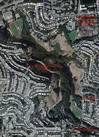
Glen Canyon Park is a city park in San Francisco, California. It occupies about 70 acres (28 ha) along a deep canyon adjacent to the Glen Park, Diamond Heights, and Miraloma Park neighborhoods. O'Shaughnessy Hollow is a rugged, undeveloped 3.6 acres (1.5 ha) tract of parkland that lies immediately to the west and may be considered an extension of Glen Canyon Park.

The Simi Hills are a low rocky mountain range of the Transverse Ranges in eastern Ventura County and western Los Angeles County, of southern California, United States.

Charyn Canyon is a canyon on the Sharyn River in Kazakhstan. The canyon is roughly 154 kilometres (96 mi) in length. It is part of the Charyn National Park, and is located within the territory of the Uygur District, Raiymbek District and Enbekshikazakh District in the Almaty Region. The canyon features many formations formed by the weathering of sedimentary rock. Though it is much smaller than the Grand Canyon, it has been described as being equally impressive.

Topanga State Park is a California state park located in the Santa Monica Mountains, within Los Angeles County, California. It is part of the Santa Monica Mountains National Recreation Area.
Cantil is an unincorporated community in Kern County, California. It is in the Fremont Valley of the western Mojave Desert.

Red Rock Canyon State Park is a state park in the U.S. state of California which features scenic desert cliffs, buttes and spectacular rock formations. The park consists of approximately 27,000 acres (110 km2) within the Mojave Sector of the Tehachapi District of the California State Park System, and is located along State Highway 14 in Kern County, about 80 miles (129 km) east of Bakersfield and 25 miles (40 km) north of Mojave, where the southernmost tip of the Sierra Nevada converges with the El Paso Mountains.

Garlock is an unincorporated community in Kern County, California, United States. It is located 6.25 miles (10 km) east-southeast of Saltdale, at an elevation of 2,169 feet.

Matthiessen State Park is an Illinois state park located a few miles south of the more famous Starved Rock State Park. The main entrances to both parks are located on Illinois State Route 178.

Panamint City is a ghost town in the Panamint Range, near Death Valley, in Inyo County, California, US. It is also known by the official Board of Geographic Names as Panamint. Panamint was a boom town founded after silver and copper were found there in 1872. By 1874, the town had a population of about 2,000. Its main street was one mile (1.6 km) long. Panamint had its own newspaper, the Panamint News. Silver was the principal product mined in the area. The town is located about three miles northwest of Sentinel Peak. According to the National Geographic Names Database, NAD27 latitude and longitude for the locale are 36°07′06″N117°05′43″W, and the feature ID number is 1661185. The elevation of this location is identified as being 6,280 feet AMSL. The similar-sounding Panamint Springs, California, is located about 25.8 miles at 306.4 degrees off true north near Panamint Junction.

Red Rock Canyon Adventure Park, previously Red Rock Canyon State Park, is located 1 mile (1.6 km) south of Hinton in Caddo County, Oklahoma. Before the settlement of Oklahoma, the area was used by Plains Indians as a winter campsite. The canyon was a stop on the California Road where settlers would gather fresh water and repair their wagons. Wagon wheel ruts are still visible in the park. The canyon has the only remaining site of native Caddo maple trees.
Red Rock Canyon may refer to:

High Desert is a vernacular region with non-discrete boundaries covering areas of the western Mojave Desert in Southern California. The region encompasses various terrain with elevations generally between 2,000 and 4,000 ft above sea level, and is located just north of the San Gabriel, San Bernardino, and Little San Bernardino Mountains.

San Timoteo Canyon is a river valley canyon southeast of Redlands, in the far northwestern foothills of the San Jacinto Mountains in the Inland Empire region of Southern California.

Desert Spring is a former settlement in Kern County, California in the Fremont Valley, south of Red Rock Canyon State Park. It was located 1.5 miles (2.4 km) northeast of Cantil.

Jawbone Canyon is a geographic feature in the Mojave Desert and a Bureau of Land Management area located in Kern County, California, 20 miles (32 km) north of Mojave on CA 14 near Cantil, CA. The area is a popular destination for hikers and off road vehicle enthusiasts.
San Felipe Creek is a stream in Imperial and San Diego Counties of California. It arises in the Volcan Mountains of San Diego County 33°11′57″N116°37′35″W, and runs eastward, gathering the waters of most of the eastern slope of the mountains and desert of the county in the San Sebastian Marsh before it empties into the Salton Sea. It is probably the last remaining perennial natural desert stream in the Colorado Desert region. In 1974, the San Felipe Creek Area was designated as a National Natural Landmark by the National Park Service.

