Roanoke, Alabama

Last updated

Roanoke, Alabama
Downtown Roanoke Alabama.JPG
Downtown Roanoke, Alabama
Randolph County Alabama Incorporated and Unincorporated areas Roanoke Highlighted 0165040.svg
Location of Roanoke in Randolph County, Alabama.
Coordinates: 33°8′56″N85°22′11″W / 33.14889°N 85.36972°W / 33.14889; -85.36972
Country United States
State Alabama
County Randolph
Government
  MayorJill Patterson
Area
[1]
  Total19.12 sq mi (49.51 km2)
  Land18.74 sq mi (48.53 km2)
  Water0.38 sq mi (0.99 km2)
Elevation
840 ft (256 m)
Population
 (2020)
  Total5,311
  Density283.46/sq mi (109.45/km2)
Time zone UTC-6 (Central (CST))
  Summer (DST) UTC-5 (CDT)
ZIP code
36274
Area code 334
FIPS code 01-65040
GNIS feature ID0153164
Website roanokealabama.org

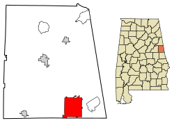
Roanoke is a city in Randolph County, which is in the Piedmont region of eastern Alabama, United States. As of the 2020 census, the population of the city was 5,311, down from 6,074 in 2010 and 6,563 in 2000.

Contents

History

Roanoke was occupied by the Creek before treaties to persuade the Native Americans to cede their land, followed by forced migration under the Indian Removal Act of 1830. The area was part of a broad part of upland developed as cotton plantations worked by enslaved African Americans. The area is still quite rural.

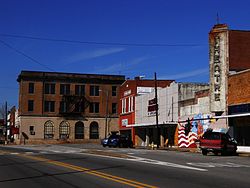
Initially called High Pine in the 1830s after a nearby creek, it was allegedly burned during an Indian uprising in 1836. Renamed Chulafinee in 1840, it was later renamed again for the hometown of one of the early settlers, Roanoke, Virginia. The city was officially incorporated in December 1890. [2]

Geography

Roanoke is located at 33°8′56″N85°22′11″W / 33.14889°N 85.36972°W / 33.14889; -85.36972 (33.148830, -85.369784). [3]

The city is located in the southern part of Randolph County along U.S. Route 431, which is the main route through the city. U.S. 431 leads northwest 13 mi (21 km) to Wedowee, the Randolph County seat, and south 21 mi (34 km) to LaFayette. Alabama State Route 22 also runs through the city, leading west 13 mi (21 km) to Wadley and northeast 9 mi (14 km) to the Georgia state line.

According to the U.S. Census Bureau, the city has a total area of 19.1 square miles (49 km2), of which 18.8 square miles (49 km2) is land and 0.3 square miles (0.78 km2) (1.47%) is water.

Local

The Mayor has been Jill Patterson since 2021.

Roanoke has three schools served by Roanoke City Schools: Knight Enloe Elementary (K-3), Handley Middle School (4-8), and Handley High School (9-12).

On December 1, 2011, the Handley High Tigers won the AHSAA Football Class 3A State Championship. In 2016 and 2020 the Handley High Tigers won the AHSAA 4A state title. [4]

Roanoke is served by a weekly newspaper, The Randolph Leader. [5]

Demographics

Historical population
CensusPop.Note
1880 327
1890 63193.0%
1900 1,15583.0%
1910 2,03476.1%
1920 3,84188.8%
1930 4,37313.9%
1940 4,168−4.7%
1950 5,39229.4%
1960 5,288−1.9%
1970 5,251−0.7%
1980 5,80910.6%
1990 6,3629.5%
2000 6,5633.2%
2010 6,074−7.5%
2020 5,311−12.6%
U.S. Decennial Census [6]
2013 Estimate [7]

2000 census

At the 2000 census there were 6,563 people in 2,467 households, including 1,660 families, in the city. The population density was 348.9 inhabitants per square mile (134.7/km2). There were 2,792 housing units at an average density of 148.4 per square mile (57.3/km2). The racial makeup of the city was 58.94% White, 39.77% Black or African American, 0.06% Native American, 0.26% Asian, 0.34% from other races, and 0.64% from two or more races. 1.19% of the population were Hispanic or Latino of any race. [8] Of the 2,467 households 30.6% had children under the age of 18 living with them, 46.9% were married couples living together, 17.3% had a female householder with no husband present, and 32.7% were non-families. 30.2% of households were one person and 13.5% were one person aged 65 or older. The average household size was 2.51 and the average family size was 3.12.

The age distribution was 26.0% under the age of 18, 8.7% from 18 to 24, 25.3% from 25 to 44, 20.8% from 45 to 64, and 19.2% 65 or older. The median age was 37 years. For every 100 females, there were 86.8 males. For every 100 females age 18 and over, there were 79.4 males.

The median household income was $26,946 and the median family income was $32,405. Males had a median income of $29,594 versus $22,135 for females. The per capita income for the city was $14,088. About 11.9% of families and 18.6% of the population were below 7% of those younger than 18 and 15.8% of those age 65 or older.

2010 census

At the 2010 census there were 6,074 people in 2,409 households, including 1,538 families, in the city. The population density was 323.1 inhabitants per square mile (124.7/km2). There were 2,817 housing units at an average density of 149.8 per square mile (57.8/km2). The racial makeup of the city was 57.6% White, 40.5% Black or African American, 0.2% Native American, 0.6% Asian, 0.2% from other races, and 0.9% from two or more races. 1.2% of the population were Hispanic or Latino of any race. [9] Of the 2,409 households 29.1% had children under the age of 18 living with them, 38.1% were married couples living together, 21.8% had a female householder with no husband present, and 36.2% were non-families. 33.1% of households were one person and 15.5% were one person aged 65 or older. The average household size was 2.45 and the average family size was 3.11.

The age distribution was 26.9% under the age of 18, 8.0% from 18 to 24, 23.5% from 25 to 44, 24.5% from 45 to 64, and 17.2% 65 or older. The median age was 37.8 years. For every 100 females, there were 80.0 males. For every 100 females age 18 and over, there were 83.4 males.

The median household income was $30,073 and the median family income was $37,007. Males had a median income of $35,096 versus $31,406 for females. The per capita income for the city was $20,286. About 25.8% of families and 31.0% of the population were below 47.7% of those younger than 18 and 13.5% of those age 65 or older.

2020 census

Roanoke racial composition [10]
RaceNum.Perc.
White (non-Hispanic)2,85153.68%
Black or African American (non-Hispanic)2,13640.22%
Native American 70.13%
Asian 430.81%
Other/Mixed 1913.6%
Hispanic or Latino 831.56%

As of the 2020 United States census, there were 5,311 people, 2,387 households, and 1,562 families residing in the city.

Notable people

Related Research Articles

<span class="mw-page-title-main">Cleburne County, Alabama</span> County in Alabama, United States

Cleburne County is a county located in the east central portion of the U.S. state of Alabama. As of the 2020 census, the population was 15,056. Its county seat is Heflin. Its name is in honor of Patrick R. Cleburne of Arkansas who rose to the rank of major general in the Confederate States Army. The eastern side of the county borders the state of Georgia.

<span class="mw-page-title-main">Randolph County, Alabama</span> County in Alabama, United States

Randolph County is a county on the central eastern border of the U.S. state of Alabama. As of the 2020 census, the population was 21,967. Its county seat is Wedowee. Its name is in honor of John Randolph, a member of the United States Senate from Virginia. Randolph County was a prohibition or dry county until 2012, when the citizens of Randolph County voted to repeal prohibition.

<span class="mw-page-title-main">Clio, Alabama</span> City in Alabama, United States

Clio is a city in Barbour County, Alabama, United States. The population was 1,399 at the 2010 census, down from 2,206 in 2000, at which time it was a town. It is the birthplace of former Alabama governor George C. Wallace, as well as Baseball Hall of Famer and former Atlanta Braves broadcaster Don Sutton.

<span class="mw-page-title-main">Glencoe, Alabama</span> City in the United States

Glencoe is a city in Calhoun and Etowah counties in the U.S. state of Alabama. It is part of the Gadsden Metropolitan Statistical Area. The city incorporated in 1939. The population was 5,160 at the 2010 census.

<span class="mw-page-title-main">Weaver, Alabama</span> City in Alabama, United States

Weaver is a city in Calhoun County, Alabama, United States. At the 2020 census, the population was 3,339. It is included in the Anniston-Oxford, Alabama Metropolitan Statistical Area.

<span class="mw-page-title-main">Fruithurst, Alabama</span> Town in Alabama, United States

Fruithurst is a town in Cleburne County, Alabama, United States. At the 2020 census, the population was 235.

<span class="mw-page-title-main">Heflin, Alabama</span> City in Alabama, United States

Heflin is a city and the county seat of Cleburne County, Alabama, United States. At the 2020 census, the population was 3,431. It is located approximately halfway between Birmingham and Atlanta along Interstate 20.

<span class="mw-page-title-main">Ranburne, Alabama</span> Town in Alabama, United States

Ranburne is a town in Cleburne County, Alabama, United States. At the 2020 census, the population was 422.

<span class="mw-page-title-main">Daleville, Alabama</span> City in Alabama, United States

Daleville is a city in Dale County, Alabama, United States. At the 2010 census the population was 5,295, up from 4,653 in 2000. It is part of the Ozark Micropolitan Statistical Area. The city's nickname is "Gateway to Fort Rucker", as this U.S. Army post is located just north of town. Cairns Army Airfield is located to the south of Daleville on the road to nearby Clayhatchee.

<span class="mw-page-title-main">Hartford, Alabama</span> City in Alabama, United States

Hartford is a city in Geneva County, Alabama, United States. It incorporated in 1896. It is part of the Dothan, Alabama Metropolitan Statistical Area. At the 2020 census, the population was 2,651, an increase over the figure of 2,624 tabulated in 2010.

<span class="mw-page-title-main">Guin, Alabama</span> City in Alabama, United States

Guin is a city in Marion County, Alabama, United States. It incorporated in December 1889. At the 2020 census, the population was 2,195.

<span class="mw-page-title-main">Frisco City, Alabama</span> Town in Alabama, United States

Frisco City is a town in Monroe County, Alabama, United States. The population was 1,170 at the 2020 census.

<span class="mw-page-title-main">Wedowee, Alabama</span> Town in Alabama, US

Wedowee is a town in Randolph County, Alabama, United States. At the 2010 census the population was 823, up from 818 in 2000. The small town is the county seat of Randolph County. It was initially incorporated in 1836, but its charter lapsed by the late 19th century. It was reincorporated in 1901.

<span class="mw-page-title-main">Pelham, Alabama</span> City in Alabama, United States

Pelham is a city in Shelby County, Alabama, United States. The population was 24,318 at the 2020 census, It incorporated on July 10, 1964 and is a suburb located in the Birmingham metropolitan area, Alabama which was home to nearly 1.2 million residents as of the 2020 census. It was named for Confederate Civil War officer John Pelham.

<span class="mw-page-title-main">Riverside, Alabama</span> City in Alabama, United States

Riverside is a city in St. Clair County, Alabama, United States. It incorporated in 1886. At the 2010 census the population was 2,208, up from 1,564 in 2000.

<span class="mw-page-title-main">Parrish, Alabama</span> Town in Alabama, United States

Parrish is a town in Walker County, Alabama, United States. It was incorporated in October 1922. At the 2010 census the population was 982, down from 1,268 in 2000.

<span class="mw-page-title-main">Fort Gaines, Georgia</span> City in Georgia, United States

Fort Gaines is a city in and the county seat of Clay County, Georgia, United States. It has a population of 1,107 as of the 2010 census.

<span class="mw-page-title-main">Randolph, Iowa</span> City in Iowa, United States

Randolph is a city in Fremont County, Iowa, United States. The population was 189 at the time of the 2020 census. It is the birthplace of Virginia Smith, Republican U.S. representative from the 3rd District of Nebraska from 1975 until 1991.

<span class="mw-page-title-main">Randolph, Minnesota</span> City in Minnesota, United States

Randolph is a city in Dakota County, Minnesota, United States. The population was 436 at the 2010 census.

Randolph Township is a township in Dakota County, Minnesota, United States. The population was 536 at the 2000 census.

References

  1. "2020 U.S. Gazetteer Files". United States Census Bureau. Retrieved October 29, 2021.
  2. James P. Kaetz, Auburn University. "Roanoke". Encyclopedia of Alabama. Retrieved October 13, 2017.
  3. "US Gazetteer files: 2010, 2000, and 1990". United States Census Bureau. February 12, 2011. Retrieved April 23, 2011.
  4. AHSAA. "AHSAA Football Past State Champions".
  5. "Randolph County's News Source Since 1892". The Randolph Leader. October 9, 2017. Retrieved October 13, 2017.
  6. "U.S. Decennial Census". Census.gov. Retrieved June 6, 2013.
  7. "Annual Estimates of the Resident Population: April 1, 2010 to July 1, 2013" . Retrieved June 3, 2014.
  8. "U.S. Census website". United States Census Bureau . Retrieved January 31, 2008.
  9. "U.S. Census website". United States Census Bureau . Retrieved August 7, 2015.
  10. "Explore Census Data". data.census.gov. Retrieved December 13, 2021.

33°08′56″N85°22′11″W / 33.14883°N 85.369784°W / 33.14883; -85.369784