Lassen County is a county in the northeastern portion of the U.S. state of California. As of the 2020 census, the population was 32,730. The county seat and only incorporated city is Susanville. Lassen County comprises the Susanville, California, micropolitan statistical area. A former farming, mining, and lumber area, its economy now depends on employment at one federal and two state prisons; the former in Herlong and the latter two in Susanville. In 2007, half the adults in Susanville worked in one of the facilities.
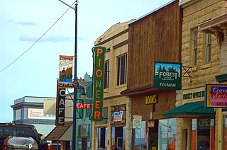
Susanville is a town in and the county seat of Lassen County, California, United States. Susanville is located on the Susan River in the southern part of the county, at an elevation of 4,186 feet (1,276 m). Its population is 16,728 as of the 2020 census, down from 17,947 from the 2010 census.
Genoa is an unincorporated town in Douglas County, Nevada, United States. Founded in 1851, it was the first settlement in what became the Nevada Territory. It is situated within Carson River Valley and is approximately 42 miles (68 km) south of Reno. The population was 939 at the 2010 census. It is home to the oldest bar in the state of Nevada which opened in 1853.
Roop County, known until 1862 as Lake County, was a county of Nevada Territory in the United States from 1861 until 1864. It was created in 1861 as one of the original nine counties of Nevada. In 1864 it was succeeded by Lassen County, California and Washoe County, Nevada.
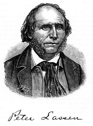
Peter Lassen, later known in Spanish as Don Pedro Lassen, was a Danish-born Californian ranchero and gold prospector. Born in Denmark, Lassen immigrated at age 30 to Massachusetts, before eventually finally moving to California. In California, Lassen became a Mexican citizen and received the vast Rancho Bosquejo from Governor Manuel Micheltorena. He is best known as the eponym of Lassen County, California, Lassen Peak, and Lassen Volcanic National Park.
The Department of the Pacific or Pacific Department was a major command (Department) of the United States Army from 1853 to 1858. It replaced the Pacific Division, and was itself replaced by the Department of California and the Department of Oregon.

Buildings, sites, districts, and objects in California listed on the National Register of Historic Places:

The Wawona Hotel is a historic hotel located within southern Yosemite National Park, in California. It was declared a National Historic Landmark in 1987, and is on the National Register of Historic Places.

Fort Osage was an early 19th-century factory trading post run by the United States Government in western Missouri on the American frontier; it was located in present-day Sibley, Missouri. The Treaty of Fort Clark, signed with certain members of the Osage Nation in 1808, called for the United States to establish Fort Osage as a trading post and to protect the Osage from tribal enemies.
The Nataqua Territory was a short-lived, unofficial territory of the United States. It consisted of a portion of what is now northeastern California and northwestern Nevada. Nataqua Territory was the first incarnation of the proposed "State of Jefferson". In 1849, the border between California and the Utah Territory was defined by geographical coordinates that were not surveyed. On April 26, 1856, local residents took advantage of this ambiguity and justified their resistance to tax collectors from Plumas County, California, by proclaiming themselves part of a new "Territory of Nataqua." The twenty men of the Susanville convention who announced the Nataqua Territory had defined a rectangle-shaped territory by latitude and longitude, which inadvertently did not include their own Honey Lake Valley but did encompass most of what soon became western Nevada, along with 600 unsuspecting inhabitants. The Territory of Nataqua was a frontier land club or claim association, designed to protect the property rights of individual settlers until regular government reached the area. The movement was led by Peter Lassen and Isaac Roop. Association with the Utah Territory was unpalatable to the residents due to anti-Mormonism.

Isaac Newton Roop was an American politician, pioneer, and member of the Whig Party. In 1859, he was the first elected (provisional) governor of the newly-proposed Nevada Territory.

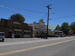
Janesville is a census-designated place in Lassen County, California. It is located 11 miles (18 km) southeast of Susanville, at an elevation of 4239 feet. Janesville is located on the eastern slopes of the Sierra Nevada Mountain range. Its population is 2,461 as of the 2020 census, up from 1,408 from the 2010 census.

The Nobles Emigrant Trail, also known as the Fort Kearney, South Pass and Honey Lake Wagon Road, is a trail in California that was used by emigrant parties from the east as a shortened route to northern California. It was pioneered in 1851 by William Nobles, who discovered an easy shortcut between the Applegate Trail in Nevada and the Lassen Trail in California. The trail was extensively used until the 1870s, when it was superseded by railroads.
The District of California was a Union Army command department formed during the American Civil War. The district was part of the Department of the Pacific, the commander of the department also being District commander. The district was created as a separate command on July 1, 1864, after Irvin McDowell took command of the Department of the Pacific, relieving General Wright, who then remained as District of California commander. The District comprised the state of California and the areas of the Rogue River and Umpqua River in Southern Oregon. Its headquarters were in San Francisco, co-located with those of the Department of the Pacific. On March 14, 1865, the District of Oregon was extended to include the entire state of Oregon, removing the Rogue River and Umpqua River areas from the District.

The Department of California was an administrative department of the United States Army. The Department was created in 1858, replacing the original Department of the Pacific, and it was ended by the reorganizations of the Henry L. Stimson Plan implemented in February 1913. As with the preceding organization, headquarters were in San Francisco. Its creation was authorized by General Orders, No. 10, of the War Department, Adjutant-General's Office, September 13, 1858.
The Sagebrush War was an armed conflict between the California county of Plumas and the now-defunct Nevada County of Roop over the jurisdiction of Lake Honey Valley and Susanville, California.
George C. Sellon was the first state architect of California.
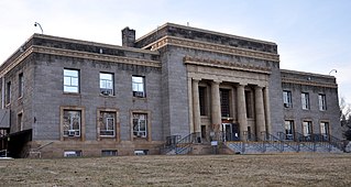
The Superior Court of California, County of Lassen, also known as the Lassen County Superior Court or Lassen Superior Court, is the branch of the California superior court with jurisdiction over Lassen County.


