06007 (Rodheim)"},"licence":{"wt":"FB"},"Gemeindeschlüssel":{"wt":"06 4 40 023"},"divisions":{"wt":"3 districts"},"website":{"wt":"[http://www.rosbach-hessen.de/ www.rosbach-hessen.de]"},"mayor":{"wt":"Steffen Maar{{cite web|url=https://statistik.hessen.de/sites/statistik.hessen.de/files/2022-10/direktwahlen_09_2022_10102022.xlsx|title=Ergebnisse der letzten Direktwahl aller hessischen Landkreise und Gemeinden|language=de|date=5 September 2022|publisher=[[Hessisches Statistisches Landesamt]]|format=XLS}}"},"leader_term":{"wt":"2018–24"},"party":{"wt":"Independent"}},"i":0}}]}" id="mwBw">Town in Hesse, Germany
Rosbach vor der Höhe | |
---|---|
Location of Rosbach vor der Höhe within Wetteraukreis district ![]() | |
Coordinates: 50°17′55″N8°42′2″E / 50.29861°N 8.70056°E | |
Country | Germany |
State | Hesse |
Admin. region | Darmstadt |
District | Wetteraukreis |
Subdivisions | 3 districts |
Government | |
• Mayor (2018–24) | Steffen Maar [1] (Ind.) |
Area | |
• Total | 45.33 km2 (17.50 sq mi) |
Elevation | 159 m (522 ft) |
Population (2022-12-31) [2] | |
• Total | 13,110 |
• Density | 290/km2 (750/sq mi) |
Time zone | UTC+01:00 (CET) |
• Summer (DST) | UTC+02:00 (CEST) |
Postal codes | 61191 |
Dialling codes | 06003 (Ober-/Nieder-Rosbach), 06007 (Rodheim) |
Vehicle registration | FB |
Website | www.rosbach-hessen.de |
Rosbach vor der Höhe is a town in the district of Wetteraukreis, in Hesse, Germany. It is located 25 kilometres north of Frankfurt am Main, on the eastern side of the Taunus mountain range. The town has a population of approximately 12,000.
The first documented mention of Rosbach took place in 884. The district Rodheim was already mentioned in 805. Archeological discoveries dates the first settlements back to Neolithic ages and the era of the Celts.
The origin of the name Rosbach is still unknown. The town was named after the nearby stream (German: Bach) of the same name, obviously. The most accepted version of the origin of the word Rosbach itself is, that it is derived from the Middle High German roezen or rozen (German: rösten; to ret). The most common craft in Rosbach was the weaving of linen [3] and retting is used to describe the process of the separation of the fibre from the stem during the production of linen.
In 884 Rosbach was annected to the Fulda monastery due to a gift by the Emperor Charles the Fat. [4] In 1663, Rosbach received town privileges under the control of the Landgraviate of Hesse-Darmstadt, the Count of Nassau and the Electorate and Archbishopric of Trier.
Rosbach was a part of the Historic road along the Long Hesse (German : de:Durch die langen Hessen ) connecting Frankfurt and Leipzig. During 1850 and 1926 manganese ore was mined in 80 mine workings. During this time the natural resource brought technological progress and the population increased dramatically. In 1901 Nieder-Rosbach was connected to the rail network of Germany as part of the rail connection between Friedberg and Bad Homburg.
In 1912 the common district of Ober- und Nieder-Rosbach was separated. In 1970 Nieder-Rosbach was incorporated by Ober-Rosbach. In August 1972 Rodheim losts its independence in terms of local politics and is a part of the town Rosbach since.
To the north, Rosbach borders Friedberg; to the east, Wöllstadt; to the south, Karben; and to the west, Bad Homburg, Friedrichsdorf and Wehrheim. Rosbach is located 25 km north of Frankfurt in the district Wetteraukreis at the Eastern side of the Taunus mountain range. The streams Fahrenbach and Rosbach in Ober-Rosbach and Nieder-Rosbach, respectively, flow into the Nidda.
Between 1998 and 2000, there was a discussion about an impact crater near Rosbach called Rosbach Krater. [5] Starting with an article in the local newspaper Wetterauer Zeitung, articles in other newspapers as the Frankfurter Rundschau and the Frankfurter Allgemeine Zeitung were published. A mineralogist and his team from the University of Marburg found planare Strukturen (lit. planar structures) of the mineral quartz, arguing these are evident results to call the crater a result of a meteorite impact. Two weeks later they revised their previous interpretation, saying those planar elements are Boehm lamellae instead. Thus the "crater" with its deformed lamellae seems to have been created during the formation of the Taunus mountain range rather than by a meteorite.
Rosbach vor der Höhe consists of three separate villages—Ober-Rosbach (Upper Rosbach), Nieder-Rosbach (Lower Rosbach) and Rodheim.
The distribution of the population is as follows:
Village | Inhabitants (2004) |
Ober-Rosbach | 4,965 |
Nieder-Rosbach | 2,551 |
Rodheim | 4,780 |
Totals | 12,296 |
![]() | This section needs to be updated.(July 2021) |
The results of the last municipal election in 2011 are listed in the table below and are compared to those of 2006 and 2001:
Parties | 2011 | 2006 | 2001 | ||||
% | Seats | % | Seats | % | Seats | ||
CDU | Christian Democratic Union | 29.1 | 9 | 34.8 | 11 | 40.6 | 15 |
SPD | Social Democratic Party of Germany | 24.5 | 8 | 23.0 | 7 | 29.8 | 11 |
GRÜNE | Alliance '90/The Greens | 13.6 | 4 | 6.7 | 2 | – | – |
FDP | Free Democratic Party | 5.6 | 2 | 6.7 | 2 | 5.2 | 2 |
FWG | Free Voters Union | 13.6 | 4 | 16.7 | 5 | 15.8 | 6 |
puR | parteiunabhängige Rosbacher | 10.2 | 3 | 7.7 | 3 | 8.7 | 3 |
PIRATEN | Pirate Party Germany | 3.4 | 1 | – | – | – | – |
Linke.WASG | Die Linke.WASG | – | – | 4.4 | 1 | – | – |
Totals | 100.0 | 31 | 100.0 | 31 | 100.0 | 37 | |
Voter turnout in % | 46.9 | 45.8 | 53.3 |
Blazon: Or, chevron gules, base flower rose gules, seeded or barbed vert, chief dexter brick tower azure, chief sinister plowshare azure. In English: A red chevron on a gold sign; at the bottom a, green barbed and golden seeded, red rose; in the upper left a blue brick tower; in the upper right a blue plowshare.
Heraldry: The plowshare stands for Nieder-Rosbach; the tower stands for Rodheim; the rose, the insignia of Ober-Rosbach, stands for Rosbach as a whole.
Rosbach is twinned with:
The town is located at the motorway access Autobahn A5 directing to Frankfurt and Kassel. This motorway access has a high traffic density as the majority of the commuters from the Western Wetteraukreis working in Frankfurt travel via Rosbach to their place of work. The train station in Nieder-Rosbach connects Friedberg and Friedrichsdorf.
The industrial park with an area of 0.44 km2 is quite huge in relation to the living area with 4.46 km2 in size. This relies on its location to the motorway access directing to Frankfurt.
The Kapersburg is located three kilometres to the west of Ober-Rosbach and is one of the best preserved Roman forts of the Limes Germanicus in Germany. It was excavated around the turn of the 20th century. In 2005, as a part of the Upper Germanic limes, the remnants of the Upper Germanic & Rhaetian Limes were inscribed on the List of UNESCO World Heritage Sites as Frontiers of the Roman Empire. Thereafter an archeological park was built around the fort. The fort was built presumably during the time of Emperor Trajan in 98, or of Emperor Hadrian in 130. The occupation withdrawed in the third century, as the occupations of other forts during that time. As a result, the fort was diminished and a wall was built in the middle of the fort. The end of the fort enforced non-violently and is dated to the middle of the third century.
The Wasserburg is not really a castle. It might have been built as a motte as insignia of the ministerialis. [6]
The Wehrturm is a fortified tower of mediaeval times in the old center of Ober-Rosbach. It is now the location of the municipal archive from the Heimatgeschichtsverein 1984 Rosbach v. d. Höhe e.V. (Association for Local History Rosbach).
The Faselstall was a former stable with a tavern in the backyard of the old town hall of Rodheim. It is now the location of the municipal archive from the Rodheimer Geschichts- und Heimatverein e.V. (Association for Local History Rodheim).
The highest point of the Eastern Taunus edge is the Steinkopf with a height of 518 m. The mountain lies in between Ober-Rosbach and Pfaffenwiesbach, part of the town Wehrheim.
Blütenfest, Altstadtfest, Schwimmbadfest, Burgfest, Rosbach goes Gospel
The Taunus is a mountain range in Hesse and Rhineland-Palatinate, Germany, located north west of Frankfurt and north of Wiesbaden. The tallest peak in the range is Großer Feldberg at 878 m; other notable peaks are Kleiner Feldberg and Altkönig.
Bad Homburg vor der Höhe is the district town of the Hochtaunuskreis, Hesse, Germany, on the southern slope of the Taunus mountains. Bad Homburg is part of the Frankfurt Rhein-Main urban area. The town's official name is Bad Homburg v.d.Höhe, which distinguishes it from other places named Homburg.
Neu-Anspach is a town in the Hochtaunuskreis in Hesse, Germany.
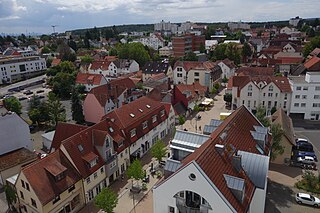
Usingen is a small town in the Hochtaunuskreis in Hessen, Germany. Until 1972, this residential and school town was the seat of the former district of Usingen.
Friedrichsdorf is a town of the Hochtaunuskreis, some 20 km (12 mi) north of Frankfurt am Main in Hesse, Germany.
Grävenwiesbach is a municipality in the Hochtaunuskreis in Hesse, Germany.
Wehrheim is a municipality in Hesse, Germany some 30 km (20 mi) north of Frankfurt am Main.
Hirzenhain is a municipality in the Wetteraukreis, in Hesse, Germany. It is located approximately 45 kilometers northeast of Frankfurt am Main. It has a population of around 2,800.
Florstadt is a town in the Wetteraukreis, in Hesse, Germany. It is located approximately 26 kilometers northeast of Frankfurt am Main. It received town privileges in 2007.
Burgholzhausen vor der Höhe is a quarter of the city of Friedrichsdorf at the foothills of the Taunus mountain range, approx. 20 km (12 mi) north of Frankfurt am Main.
Bundesstraße 455 is a German Bundesstraße in the federal state of Hesse. The route runs southwest from Schotten in Vogelsbergkreis to Mainz-Kastel, a borough of the Hessian capital city of Wiesbaden.
The Steinkopf near Ober-Rosbach in the county of Wetteraukreis and Pfaffenwiesbach in the county of Hochtaunuskreis in the German state of Hesse is a hill, 518 m above sea level (NHN), in the eastern Taunus and the easternmost Taunus eminence over 300 m. It has an isolation of 10.170 km and a prominence of 173 m and is thus one of the five independent summits in the Taunus. The Steinkopf is a landmark visible from a long distance especially for the immediately adjacent region of Wetterau to the east.
Rosbach is a river in Hesse, Germany, with a length of 9 kilometres (5.6 mi). The river is a right tributary of the Nidda which itself is a right tributary of the Main river in Hesse. The river Rosbach gives the town Rosbach vor der Höhe its name.
Bad Vilbel station is located at the 183.6 kilometre mark of the Main-Weser Railway in the town of Bad Vilbel in the German state of Hesse. The Nidder Valley Railway branches from Bad Vilbel via Nidderau to Glauburg-Stockheim. It is classified by Deutsche Bahn as a category 3 station.
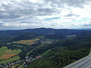
The Taunus Nature Park is a nature park in Central Germany with an area of 134,775 hectares (1347.75 km2) in the Central Upland range of the Taunus. It is one of two Hessian nature parks in the Taunus and the second largest nature park in Hesse.
The English Church is a former Church of England church building in the German city of Bad Homburg in Hesse. It is listed as a historic monument and now houses a cultural centre.
Rodheim vor der Höhe station is a railway station in the Rodheim vor der Höhe district of Rosbach vor der Höhe, located in the Wetteraukreis district in Hesse, Germany.
The Friedrichsdorf–Friedberg railway is a single-track, non-electrified branch line in the German state of Hesse. It is listed as timetable route 636 and integrated in the Rhein-Main-Verkehrsverbund as line 16.
Usingen station is the station of Usingen in the German state of Hesse) and the operations centre of the Taunus Railway from Brandoberndorf via Grävenwiesbach and Usingen to Bad Homburg. The entrance building is heritage-listed.
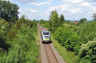
Grävenwiesbach station is the station of Grävenwiesbach on the edge of the Hochtaunuskreis in the German state of Hesse. It is located on the southern outskirts of the town centre. Previously, the station was a junction station that served trains running on the Weil Valley Railway to Weilburg via Weilmünster, on the Taunus Railway to Bad Homburg and on the Solms Valley Railway to Wetzlar.