
The Snake River is a major river of the greater Pacific Northwest region in the United States. At 1,078 miles (1,735 km) long, it is the largest tributary of the Columbia River, in turn, the largest North American river that empties into the Pacific Ocean. The Snake River rises in western Wyoming, then flows through the Snake River Plain of southern Idaho, the rugged Hells Canyon on the Oregon–Idaho border and the rolling Palouse Hills of Washington, emptying into the Columbia River at the Tri-Cities in the Columbia Basin of Eastern Washington.
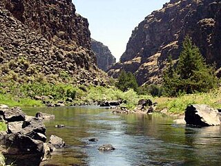
The Bruneau River is a 153-mile-long (246 km) tributary of the Snake River, in the U.S. states of Idaho and Nevada. It runs through a narrow canyon cut into ancient lava flows in southwestern Idaho. The Bruneau Canyon, which is up to 1,200 feet (370 m) deep and 40 miles (64 km) long, features rapids and hot springs, making it a popular whitewater trip.
Fort Hall was a fort in the western United States that was built in 1834 as a fur trading post by Nathaniel Jarvis Wyeth. It was located on the Snake River in the eastern Oregon Country, now part of present-day Bannock County in southeastern Idaho. Wyeth was an inventor and businessman from Boston, Massachusetts, who also founded a post at Fort William, in present-day Portland, Oregon, as part of a plan for a new trading and fisheries company. Unable to compete with the powerful British Hudson's Bay Company, based at Fort Vancouver, in 1837 Wyeth sold both posts to it. Great Britain and the United States both operated in the Oregon Country in these years.

The Owyhee River is a tributary of the Snake River located in northern Nevada, southwestern Idaho and southeastern Oregon in the United States. It is 280 miles (450 km) long. The river's drainage basin is 11,049 square miles (28,620 km2) in area, one of the largest subbasins of the Columbia Basin. The mean annual discharge is 995 cubic feet per second (28.2 m3/s), with a maximum of 50,000 cu ft/s (1,400 m3/s) recorded in 1993 and a minimum of 42 cu ft/s (1.2 m3/s) in 1954.

Henrys Fork is a tributary river of the Snake River, approximately 127 miles (204 km) long, in southeastern Idaho in the United States. It is also referred to as the North Fork of the Snake River. Its drainage basin is 3,212 square miles (8,320 km2), including its main tributary, the Teton River. Its mean annual discharge, as measured at river mile 9.2 by the United States Geological Survey (USGS), is 2,096 cubic feet per second (59.4 m3/s), with a maximum daily recorded flow of 79,000 cubic feet per second (2,240 m3/s), and a minimum of 183 cubic feet per second (5.18 m3/s). It is normally transcribed without an apostrophe.

The Pend Oreille River is a tributary of the Columbia River, approximately 130 miles (209 km) long, in northern Idaho and northeastern Washington in the United States, as well as southeastern British Columbia in Canada. In its passage through British Columbia its name is spelled Pend-d'Oreille River. It drains a scenic area of the Rocky Mountains along the U.S.-Canada border on the east side of the Columbia. The river is sometimes defined as the lower part of the Clark Fork, which rises in western Montana. The river drains an area of 66,800 square kilometres (25,792 sq mi), mostly through the Clark Fork and its tributaries in western Montana and including a portion of the Flathead River in southeastern British Columbia. The full drainage basin of the river and its tributaries accounts for 43% of the entire Columbia River Basin above the confluence with the Columbia. The total area of the Pend Oreille basin is just under 10% of the entire 258,000-square-mile (670,000 km2) Columbia Basin. Box Canyon Dam is currently underway on a multimillion-dollar project for a fish ladder.

The Malheur River is a 190-mile-long (306 km) tributary of the Snake River in eastern Oregon in the United States. It drains a high desert area, between the Harney Basin and the Blue Mountains and the Snake.
The Bear River is the largest tributary of the Great Salt Lake, draining a mountainous area and farming valleys northeast of the lake and southeast of the Snake River Plain. It flows through southwestern Wyoming, southeastern Idaho, and northern Utah, in the United States. Approximately 350 miles (560 km) long it is the longest river in North America that does not ultimately reach the sea.

The Boise River is a 102-mile-long (164 km) tributary of the Snake River in the Northwestern United States. It drains a rugged portion of the Sawtooth Range in southwestern Idaho northeast of Boise, as well as part of the western Snake River Plain. The watershed encompasses approximately 4,100 square miles (11,000 km2) of highly diverse habitats, including alpine canyons, forest, rangeland, agricultural lands, and urban areas.
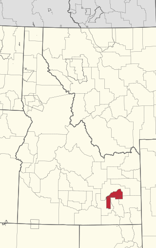
The Fort Hall Reservation is a Native American reservation of the federally recognized Shoshone-Bannock Tribes in the U.S. state of Idaho. This is one of five federally recognized tribes in the state. The reservation is located in southeastern Idaho on the Snake River Plain about 20 miles (32 km) north and west of Pocatello. It comprises 814.874 sq mi (2,110.51 km2) of land area in four counties: Bingham, Power, Bannock, and Caribou. To the east is the 60-mile-long (97 km) Portneuf Range; both Mount Putnam and South Putnam Mountain are located on the Fort Hall Reservation.

The Payette River is an 82.7-mile-long (133.1 km) river in southwestern Idaho and is a major tributary of the Snake River.

The American Falls Dam is a concrete gravity-type dam located near the town of American Falls, Idaho, on river mile 714.7 of the Snake River. The dam and reservoir are a part of the Minidoka Project on the Snake River Plain and are used primarily for flood control, irrigation, and recreation. When the original dam was built by the Bureau of Reclamation, the residents of American Falls were forced to relocate three-quarters of their town to make room for the reservoir. A second dam was completed in 1978 and the original structure was demolished. Although the dam itself is located in Power County, its reservoir also stretches northeastward into both Bingham County and Bannock County.

The Jarbidge River is a 51.8-mile-long (83.4 km), high elevation river in Elko County, Nevada and Owyhee County, Idaho in the United States. The Jarbidge originates as two main forks in the Jarbidge Mountains of northeastern Nevada and then flows through basalt and rhyolite canyons on the high plateau of the Owyhee Desert before joining the Bruneau River.

The Big Wood River is a 137-mile-long (220 km) river in central Idaho, United States, that is a tributary of the Malad River.
Interstate 15 (I-15) is a part of the Interstate Highway System that runs from San Diego, California, to Sweetgrass, Montana. In Idaho, the Interstate Highway runs exactly 196 miles (315 km) from the Utah state line near Woodruff north to the Montana state line at Monida Pass. I-15 is the primary north–south highway of Eastern Idaho. The Interstate Highway connects Pocatello and Idaho Falls, the fourth and fifth largest cities in Idaho, and the smaller county seats of Malad City, Blackfoot, and Dubois. I-15 connects all of those cities with Salt Lake City to the south and Butte to the north. The Interstate has business loops through McCammon, Inkom, Pocatello, Blackfoot, and Idaho Falls.

The Clearwater River is in the northwestern United States, in north central Idaho. Its length is 74.8 miles (120.4 km), it flows westward from the Bitterroot Mountains along the Idaho-Montana border, and joins the Snake River at Lewiston. In October 1805, the Lewis and Clark Expedition descended the Clearwater River in dugout canoes, putting in at "Canoe Camp," five miles (8 km) downstream from Orofino; they reached the Columbia Bar and the Pacific Ocean about six weeks later.

Salmon Falls Creek is a tributary of the Snake River, flowing from northern Nevada into Idaho in the United States. Formed in high mountains at the northern edge of the Great Basin, Salmon Falls Creek flows northwards 121 miles (195 km), draining an arid and mountainous basin of 2,103 square miles (5,450 km2). The Salmon Falls Creek valley served as a trade route between the Native American groups of the Snake River Plain and Great Basin. Today, most of its water is used for irrigation.
The Snake River Aquifer is a large reservoir of groundwater underlying the Snake River Plain in the southern part of the U.S. state of Idaho. Most of the water in the aquifer comes from rain and melting snow that flows onto the plain from the Snake River, Big Lost River and other lost streams of Idaho, Bruneau River, and other watercourses of southern Idaho. Measuring about 400 miles (640 km) from east to west, it is an important water source for agricultural irrigation in the Plain. The Snake River Aquifer is commonly defined as two separate parts, separated by Salmon Falls Creek: the Eastern Snake River Plain Aquifer and Western Snake River Plain Aquifer.

The Potlatch River is in the state of Idaho in the United States. About 56 miles (90 km) long, it is the lowermost major tributary to the Clearwater River, a tributary of the Snake River that is in turn a tributary of the Columbia River. Once surrounded by arid grasslands of the Columbia Plateau adjacent to the western foothills of the Rocky Mountains, the Potlatch today is used mainly for agriculture and irrigation purposes.

The historic 2,170-mile (3,490 km) Oregon Trail connected various towns along the Missouri River to Oregon's Willamette Valley. It was used during the 19th century by Great Plains pioneers who were seeking fertile land in the West and North.
