
Hopkinton is a town in Merrimack County, New Hampshire, United States. The population was 5,914 at the 2020 census. The town has three distinct communities: Hopkinton village, mainly a residential area in the center of the town; Contoocook, the town's business hub, located in the north; and West Hopkinton, within the more agricultural portion of the town. The town is home to the Hopkinton State Fair, adjacent to Contoocook village, and to the historic Contoocook Railroad Depot and the Contoocook Railroad Bridge, the oldest covered railroad bridge in the United States.

The Columbia Bridge is a covered bridge, carrying Columbia Bridge Road over the Connecticut River between Columbia, New Hampshire and Lemington, Vermont. Built in 1911–12, it is one of only two New Hampshire bridges built with Howe trusses, and is one of the last covered bridges built in the historic era of covered bridge construction in both states. It was listed on the National Register of Historic Places in 1976.

The Mount Orne Bridge is a covered bridge over the Connecticut River between Lancaster, New Hampshire, and Lunenburg, Vermont. It joins Elm Street in South Lancaster with River Road in Lunenburg. Built in 1911, it is one of two Howe truss bridges across the Connecticut River. It was listed on the National Register of Historic Places in 1976.

The Bedell Bridge was a Burr truss covered bridge that spanned the Connecticut River between Newbury, Vermont and Haverhill, New Hampshire. Until its most recent destruction in 1979, it was, with a total length of 382 feet (116 m), the second-longest covered bridge in the United States. The bridge was divided into two spans of roughly equal length, and rested on a central pier and shore abutments constructed from mortared rough stone. The eastern abutment has been shored up by the addition of a concrete footing. The bridge was 23 feet (7.0 m) wide, with a roadway width of 18.5 feet (5.6 m). Because the state line is the western low-water mark of the Connecticut River, most of the bridge was in New Hampshire; only the western abutment is in Vermont.

The Ashuelot Covered Bridge is a historic wooden covered bridge over the Ashuelot River on Bolton Road, just south of its intersection with NH 119 in Ashuelot, an unincorporated village of Winchester, New Hampshire. Built in 1864-65, it is one of the state's few surviving 19th-century covered bridges. It was listed on the National Register of Historic Places in 1981.

The Stark Covered Bridge is a historic wooden covered bridge over the Upper Ammonoosuc River in Stark, New Hampshire. It carries a connecting roadway which joins the Northside Road to New Hampshire Route 110. The bridge was built in either 1857 or 1862, replacing a floating bridge that had been located a short way upstream. It is a two-span Paddleford truss bridge, which is a regional variant of the Long truss. It is 151 feet (46 m) long with a span of 138 feet (42 m), and is 29 feet (8.8 m) wide, carrying an 18-foot (5.5 m) wide roadway and two 6.5-foot (2.0 m) sidewalks. The shore ends of the bridge rest on abutments of granite stone, while the center of the bridge is supported by a reinforced concrete pier, which is flared on the upstream side to deflect debris. The bridge is reinforced with steel beams, giving it a carrying capacity of 15 tons. It is decorated with pendant acorn finials and painted bright white.
The Meadow Bridge was a historic bridge across the Androscoggin River located on a spur of North Road in Shelburne, New Hampshire. It was a multi-span pin-connected truss bridge that was the first on its site when it was built in 1897 by the Groton Bridge and Manufacturing Co. The bridge consisted of three central through Pratt trusses, one pony Pratt truss, and one steel girder section. The ends of the bridge rested on stone abutments, while the interior spans were supported by circular steel piers filled with concrete and anchored in place by timber piles. The bridge was bypassed in 1984 by a modern bridge. In 2004 it was dismantled and stored on the banks of the river for future rehabilitation.

The West Dummerston Covered Bridge is a historic covered bridge spanning the West River in Dummerston, Vermont, between Vermont Route 30 and Camp Arden Road. Built in 1872, it is at 280 feet (85 m) the longest covered bridge entirely within the state of Vermont. It was listed on the National Register of Historic Places in 1973.

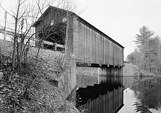
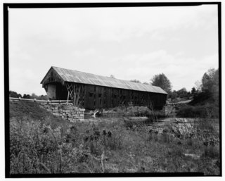
The Contoocook Railroad Bridge is a covered bridge on the former Contoocook Valley Railroad line spanning the Contoocook River in the center of the village of Contoocook, New Hampshire, United States. It is referred to in the National Register of Historic Places as the Hopkinton Railroad Covered Bridge, for the town of Hopkinton, New Hampshire, in which the village of Contoocook is located.

The Dalton Covered Bridge, also called the Dalton Bridge, is a historic covered bridge that carries Joppa Road over the Warner River in Warner, New Hampshire. Its name refers to a nearby resident at the time of its construction. The bridge was built in 1853 by Joshua Sanborn, and its original abutments were built by George Sawyer and Webster Davis; all were local residents. The bridge has a span of 76 feet (23 m), with a total bridge length of 84 feet (26 m). The bridge is 17 feet (5.2 m) wide, with a road bed width of 14 feet (4.3 m), although guard rails have reduced its usable width to just under 13 feet (4.0 m).
The Hancock–Greenfield Bridge is a historic covered bridge carrying Forest Road over the Contoocook River at the town line between Hancock and Greenfield, New Hampshire. The New Hampshire Department of Transportation covered bridge database refers to it as County Bridge. Built in 1937, it is the first wooden covered bridge in the northeastern United States to use modern engineering techniques. The bridge was listed on the National Register of Historic Places in 1981.

The Contoocook Railroad Depot is located in Hopkinton, New Hampshire, United States, in the village of Contoocook. The depot was completed in 1849 as one of the first substantial railroad passenger stations west of Concord on the Concord and Claremont Railroad. The building is one of the best preserved of a small number of gable-roofed railroad stations surviving from the first decade of rail development in New Hampshire. The station exemplifies the pioneering period of rail development in the state.

The Sulphite Railroad Bridge, also known locally as the Upside-Down Covered Bridge is a historic railroad bridge in Franklin, New Hampshire. The bridge was built circa 1896-7 to carry the tracks of the Boston and Maine Railroad across the Winnipesaukee River between Franklin and Tilton. The bridge is believed to be the only surviving "upside down" covered railroad bridge in the United States, in which the rail bed is laid on top of the bridge roof, whose purpose is to shelter the trusses below. The bridge was listed on the National Register of Historic Places in 1975. The bridge, unused since 1973, is not in good condition, having been subjected to graffiti, vandalism, and arson, as well as the elements.
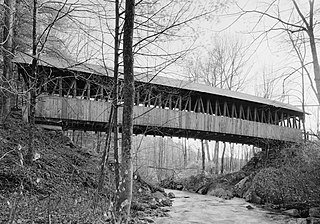
The Durgin Bridge is a covered bridge carrying Durgin Bridge Road over the Cold River in eastern Sandwich, New Hampshire. Built in 1869, it is a rare surviving example of a Paddleford truss bridge, and one of the few surviving 19th-century covered bridges in New Hampshire. It was listed on the National Register of Historic Places in 1983.

The Hillsborough Railroad Bridge was a historic covered railroad bridge spanning the Contoocook River in Hillsborough, New Hampshire. Built in 1903 by the Boston and Maine Railroad, it was destroyed by arson in 1985. The bridge was listed on the National Register of Historic Places in 1975. At the time of its nomination it was one of six covered railroad bridges in the state; it and at least one other were destroyed by the actions of arsonists.
The Kenyon Bridge, also known as the Blacksmith Shop Bridge, is a historic covered bridge spanning Mill Brook near Town House Road in Cornish, New Hampshire, United States. Built in 1882, it is one of New Hampshire's few surviving 19th-century covered bridges. It was listed on the National Register of Historic Places in 1978.

The Pier Bridge is a historic covered bridge in Newport, New Hampshire. Originally built in 1907 to carry the Boston and Maine Railroad across the Sugar River, it now carries the multi-use Sugar River Trail, which was built on the abandoned right-of-way. It is one of a modest number of historic covered bridges in New Hampshire, and is named for the fact that it has a central pier. The bridge was listed on the National Register of Historic Places in 1975.

The Tilton Island Park Bridge is a foot bridge in Tilton, New Hampshire. It spans a portion of the Winnipesaukee River just east of downtown Tilton, providing access to Tilton Island Park, located on an island in the river. Built in 1881, it is a rare surviving example of a bridge with cast iron components, designed by a distinctive patent issued in 1858 to Lucius Truesdell. The bridge was listed on the National Register of Historic Places in 1980.
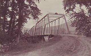
New Henniker Bridge or New Bridge was a covered bridge in West Hopkinton, New Hampshire, which carried Henniker Road over the Contoocook River. The truss bridge was completed in 1863, and was the second bridge on the site. The original stone arch bridge was built in 1845 and was washed away by flood in 1852. The bridge was just over 20 feet (6.1 m) wide and 180 feet (55 m) long, and consisted of a single span supported by two triple lattice trusses resting on granite abutments. The patent drawings show an all-timber truss with fixed intersection angles in the center of the span. At the ends of the span the angles of the diagonals vary. The end post is vertical, and each brace further from it is sloped a little more.

The Lyme–East Thetford Bridge is a historic bridge over the Connecticut River between Lyme, New Hampshire, and East Thetford, Vermont. From the New Hampshire side it carries East Thetford Road, which becomes Vermont Route 113 as it enters Vermont. A Parker truss bridge completed in 1937, it is 471 feet (144 m) long. The bridge was added to the National Register of Historic Places in 2020.


