Related Research Articles

Yamhill County is one of the 36 counties in the U.S. state of Oregon. As of the 2020 census, the population was 107,722. The county seat is McMinnville. Yamhill County was named after the Yamhelas, members of the Kalapuya Tribe.

McMinnville is the county seat of and largest city in Yamhill County, Oregon, United States. The city is named after McMinnville, Tennessee. As of the 2019 census, the city had a population estimate of 34,743.

Willamina is a city in Polk and Yamhill Counties in the U.S. state of Oregon. The population was 2,025 at the 2010 census.
The Oregon Electric Railway (OE) was an interurban railroad line in the U.S. state of Oregon that linked Portland to Eugene. Service from Portland to Salem began in January 1908. The Spokane, Portland and Seattle Railway purchased the system in 1910, and extended service to Eugene in 1912. Regular passenger service in the Willamette Valley ended in May 1933. Freight operations continued and the railway survived into the 1990s, ultimately as a Burlington Northern feeder. Operation as an electric railroad ended July 10, 1945.

The Yamhill River is an 11-mile (18 km) tributary of the Willamette River, in the U.S. state of Oregon. Formed by the confluence of the South Yamhill River and the North Yamhill River about 3 miles (5 km) east of McMinnville, it drains part of the Northern Oregon Coast Range. The river meanders east past Dayton to join the Willamette River at its river mile (RM) 55 or river kilometer (RK) 89, south of Newberg.
The Portland and Western Railroad is a 466-mile (750 km) Class II railroad serving the U.S. state of Oregon, and is a wholly owned subsidiary of shortline and regional railroad holding company Genesee & Wyoming Inc. The PNWR includes a subsidiary, the Willamette and Pacific Railroad.

Oregon Route 99W is a state-numbered route in Oregon, United States, that runs from OR 99 and OR 99E in Junction City north to I-5 in southwestern Portland. Some signage continues it north to US 26 near downtown, but most signage agrees with the Oregon Department of Transportation's (ODOT) description, ending it at I-5. OR 99W is known by ODOT as the Pacific Highway West No. 1W ; that highway continues north through downtown to the Pacific Highway No. 1 (I-5) in northern Portland, as well as south on OR 99 to the Pacific Highway (I-5) in Eugene.

Whiteson is an unincorporated community in Yamhill County, Oregon, United States. Oregon Geographic Names states that Whiteson is named for either for Henry White, who laid out the town site and gave the railroad right-of-way, or for William White. It is possible they are members of the same family. Whiteson post office was established in 1890. Whiteson is an agricultural community lacking either Oregon hamlet or village classification, and relies on the neighboring communities of McMinnville and Amity for basic services such as fire, health, and education. The Yamhill County Sheriff has primary police jurisdiction over Whiteson.

The Willamette Valley AVA is an American Viticultural Area which lies in the Willamette Valley of Oregon. The AVA is the wine growing region which encompasses the drainage basin of the Willamette River. It stretches from the Columbia River in the north to just south of Eugene in the south, where the Willamette Valley ends; and from the Oregon Coast Range in the west to the Cascade Mountains in the east. At 5,360 square miles (13,900 km2), it is the largest AVA in the state, and contains most of the state's wineries; approximately 200 as of 2006.
Rail transportation is an important element of the transportation network in the U.S. state of Oregon. Rail transportation has existed in Oregon in some form since 1855, and the state was a pioneer in development of electric railway systems. While the automobile has displaced many uses of rail in the state, rail remains a key means of moving passengers and freight, both within the state and to points beyond its borders.

The steamship Altona operated from 1890 to 1907 on the Willamette River in the U.S. state of Oregon. In 1907, she was transferred to Alaska.

The Oregon Central Rail Road was the name of two railroad companies in the U.S. state of Oregon, each of which claimed federal land grants that had been assigned to the state in 1866 to assist in building a line from Portland south into California. The "East Side Company" of Salem, supported by businessman Ben Holladay, eventually received the grant for its line east of the Willamette River, and was reorganized in 1870 as the Oregon and California Railroad (O&C), which completed the line in 1887. Portland supported the competing "West Side Company", which only built to McMinnville, and was sold to the O&C in 1880. The O&C was later acquired by the Southern Pacific Company, and mostly remains as part of the Union Pacific Railroad's I-5 Corridor; the West Side line is now operated by the Portland and Western Railroad between Beaverton and Forest Grove.
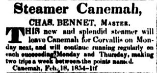
Canemah was one of the first steamboats to run on the Willamette River above Willamette Falls. Canemah was the first steamboat to load grain at Corvallis, the first to carry the mail on the Willamette River, and the first steamboat in Oregon to suffer a fatal boiler explosion.

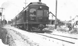
The Southern Pacific Red Electric Lines, also known simply as the Red Electric, was a network of interurban passenger train services operated by the Southern Pacific Railroad in the Willamette Valley of the U.S. state of Oregon from 1914 to 1929. The service got its name from the bright red color of its cars. Despite its short history, among West Coast interurbans it was unique, and it was considered the finest such system in the Pacific Northwest. It was the only major electric interurban railroad converted from steam to electric passenger use. It was also one of few systems using all-steel equipment, and one of the largest 1500-volt systems in the country.

The Willamette Valley is a 150-mile (240 km) long valley in Oregon, in the Pacific Northwest region of the United States. The Willamette River flows the entire length of the valley and is surrounded by mountains on three sides: the Cascade Range to the east, the Oregon Coast Range to the west, and the Calapooya Mountains to the south.

The Yamhill River lock and dam was completed in 1900. It was built near Lafayette, Oregon, to allow better river transport on the Yamhill River from Dayton, to McMinnville, Oregon. While the Corps of Engineers had recommended against construction of the lock, it was built anyway, largely as a result of political effort by the backers of the project. For almost forty years prior to the lock construction there had been efforts made to construct a lock and dam on the Yamhill River.

The People's Transportation Company operated steamboats on the Willamette River and its tributaries, the Yamhill and Tualatin rivers, in the State of Oregon from 1862 to 1871. For a brief time this company operated steamers on the Columbia River, and for about two months in 1864, the company operated a small steamer on the Clackamas River.

Dayton was a steamboat which operated on the Willamette and Columbia rivers from 1868 to 1881. Dayton operated on the Willamette from 1868 to 1876, mostly upriver from Willamette Falls, including a route on the Yamhill River to Dayton, Oregon, after which the steamer was named. From 1876 to 1881, Dayton was employed on a run from Portland to Monticello, W.T., which was located on the site of what is now Longview, Washington.

Albany was a stern-wheel driven steamboat that operated on the Willamette River from 1868 to 1875. This vessel should not be confused with the later sternwheeler Albany, which ran, also on the Willamette River, from 1896 to 1906, when it was rebuilt and renamed Georgie Burton.
References
- ↑ "Saint Joseph". Geographic Names Information System . United States Geological Survey. November 28, 1980. Retrieved December 18, 2010.
- ↑ Oregon Atlas & Gazetteer (7th ed.). Yarmouth, Maine: DeLorme. 2008. p. 27. ISBN 0-89933-347-8.
- 1 2 3 4 5 6 7 8 9 10 Rohse, Elaine (February 24, 2010). "Rohse Colored Glasses: Ghost towns of the county's past". Yamhill Valley News-Register . Retrieved December 18, 2010.
- 1 2 3 McArthur, Lewis A.; McArthur, Lewis L. (2003) [1928]. Oregon Geographic Names (7th ed.). Portland, Oregon: Oregon Historical Society Press. p. 838. ISBN 978-0875952772.
- ↑ Writers' Program of the Work Projects Administration in the State of Oregon (1940). Oregon: End of the Trail . American Guide Series. Portland, Oregon: Binfords & Mort. p. 482. OCLC 4874569.
St. Joe.
- 1 2 "The Red Electrics". PDXHistory.com. Retrieved December 18, 2010.
- ↑ Lowry, Robert; Kenneth Munford; Harriet Moore (1979). "Railroading in the Lower Willamette Valley". Benton County Historical Society and Museum. Archived from the original on December 13, 2010. Retrieved December 18, 2010.
- ↑ "Managing the Railroads". New York Times . January 20, 1887. p. 5.
- 1 2 3 4 5 6 "The Abandoned Southern Pacific Railroad St. Joseph Branch". Abandoned Railroads of the Pacific Northwest. Retrieved December 19, 2010.
- ↑ "Old Home Eyes Changing Scene". Unknown. August 23, ????. Archived from the original on March 4, 2016. Retrieved March 28, 2018.
