Hawkesbury Quarry is a 0.25-hectare (0.62-acre) geological Site of Special Scientific Interest near the village of Hawkesbury Upton, South Gloucestershire, notified in 1967.
Lulsgate Quarry is a 1.13 hectare geological Site of Special Scientific Interest near the village of Felton, North Somerset, notified in 1997.
Dinton Quarry is a 3,000 square metre geological Site of Special Scientific Interest in Wiltshire, notified in 1990. This long-disused quarry of Middle Purbeck limestone was the main source of the late Jurassic fossil insects described by Brodie in 1845.
Hobbs Quarry is a 0.5 hectare geological Site of Special Scientific Interest near Shepton Mallet on the Mendip Hills in Somerset, notified in 1984.
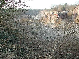
Cloford Quarry is a 39.92-hectare (98.6-acre) geological Site of Special Scientific Interest to the south of the A361 approximately 350 metres (1,150 ft) north of the hamlet of Cloford and 1 kilometre (0.6 mi) west of Nunney on the Mendip Hills in Somerset. It was notified in 1994.

West Yatton Down is a 14.4 hectare biological Site of Special Scientific Interest in Wiltshire, notified in 1971.

Viaduct Quarry is a 0.3 hectare geological Site of Special Scientific Interest near Shepton Mallet on the Mendip Hills in Somerset, notified in 1984.

Chalbury Hill And Quarry is an 11.9 hectare biological and geological Site of Special Scientific Interest in Dorset, England, notified in 1977. The site consists of grassland and a disused limestone quarry. The SSSI includes the area covered by Chalbury Hill Fort.

Barnack Hills & Holes is a 23.3 hectare biological Site of Special Scientific Interest in Barnack in Cambridgeshire. It is also a national nature reserve. It is a Nature Conservation Review site, Grade I. In 2002 it was designated as a Special Area of Conservation, to protect the orchid rich grassland as part of the Natura 2000 network of sites throughout the European Union.

Fishburn Grassland is a Site of Special Scientific Interest in the Sedgefield district of County Durham, England. It lies between the villages of Fishburn and Trimdon, just north of the former.
Yoden Village Quarry is a Site of Special Scientific Interest in the Easington district of east County Durham, England. It is a disused quarry in the Horden district of Peterlee, adjacent to the site of the medieval village of Yoden.
Hawthorn Dene is a Site of Special Scientific Interest in the Easington district of County Durham, England. The site occupies the incised valley of Hawthorn Burn and extends from just south of the village of Hawthorn eastward as far as the Durham Coast railway line: the area between the railway line and the sea forms part of the Durham Coast SSSI.
Hulam Fen is a Site of Special Scientific Interest in the Easington district of east County Durham, England, just south of the village of Hesleden, about 8 km north-west of Hartlepool.
Pig Hill is a Site of Special Scientific Interest in the County Durham district of north-east County Durham, England, situated 1 km south of the village of Easington Lane.
Quarrington Hill Grasslands is a Site of Special Scientific Interest in County Durham, England. The site consists of three separate areas, two closely adjacent to the east of the village of Quarrington Hill, the third immediately west of the village, which lies 8 km south-east of Durham City.
Raisby Hill Grassland is a Site of Special Scientific Interest in east County Durham, England. It lies just over 1 km east of the village of Coxhoe.
Raisby Hill Quarry is a Site of Special Scientific Interest in east County Durham, England. It lies just under 2 km east of the village of Coxhoe.
Sherburn Hill is a Site of Special Scientific Interest in County Durham, England. It lies just south of the road between the villages of Sherburn and Sherburn Hill, some 5.5 km east of Durham city. A disused quarry occupies part of the site.
The Carrs is a Site of Special Scientific Interest in the Sedgefield district of County Durham, England. It is situated on the eastern outskirts of Ferryhill, between the town and the East Coast Main Line railway.
Town Kelloe Bank is a Site of Special Scientific Interest in County Durham, England. It is situated to the south of The Bottoms SSSI and just north of the village of Town Kelloe.
This page is based on this
Wikipedia article Text is available under the
CC BY-SA 4.0 license; additional terms may apply.
Images, videos and audio are available under their respective licenses.
