Sheffield Parish, New Brunswick

Last updated

Sheffield
Sunbury County NB - Sheffield Parish.PNG
Location within Sunbury County, New Brunswick
Country Flag of Canada (Pantone).svg  Canada
Province Flag of New Brunswick.svg  New Brunswick
County Sunbury County
Erected1786
Area
[1]
  Land271.29 km2 (104.75 sq mi)
Population
 (2021) [1]
  Total888
  Density3.3/km2 (9/sq mi)
  Change 2016-2021
Increase2.svg 9.8%
  Dwellings
499
Time zone UTC-4 (AST)
  Summer (DST) UTC-3 (ADT)

Sheffield is a geographic parish in Sunbury County, New Brunswick, Canada. [2]

Contents

Prior to the 2023 governance reform, for governance purposes it formed the local service district of the parish of Sheffield, [3] which was a member of Capital Region Service Commission (RSC11). [4]

Origin of name

The parish was named for Baron Sheffield, notable as a friend of the province. [5]

History

Sheffield was erected in 1786 as one of Sunbury County's original parishes; [6] it extended twenty-five miles inland and included part of Northfield Parish.

In 1850 Sheffield was extended to the county line, adding unassigned territory to its rear. [7]

In 1855 the parish was split into two polling districts, Eastern and Western. [8] The boundary ran along the modern parish line with Northfield.

In 1857 the Eastern District was erected as Northfield Parish. [9]

Boundaries

Sheffield Parish is bounded: [2] [10] [11]

Communities

Communities at least partly within the parish. [10] [11] [12]

Bodies of water

Bodies of water [lower-alpha 1] at least partly within the parish. [10] [11] [12]

Islands

Islands at least partly within the parish. [10] [11] [12]

Other notable places

Parks, historic sites, and other noteworthy places at least partly within the parish. [10] [11] [12]

Demographics

Access Routes

Highways and numbered routes that run through the parish, including external routes that start or finish at the parish limits: [18]

See also

Notes

  1. Not including brooks, ponds or coves.

Related Research Articles

<span class="mw-page-title-main">Waterborough Parish, New Brunswick</span> Parish in New Brunswick, Canada

Waterborough is a geographic parish in Queens County, New Brunswick, Canada.

<span class="mw-page-title-main">Kingsclear Parish, New Brunswick</span> Parish in New Brunswick, Canada

Kingsclear is a geographic parish in York County, New Brunswick, Canada.

<span class="mw-page-title-main">Queensbury Parish, New Brunswick</span> Parish in New Brunswick, Canada

Queensbury is a geographic parish in York County, New Brunswick, Canada.

<span class="mw-page-title-main">Hampstead Parish, New Brunswick</span> Parish in New Brunswick, Canada

Hampstead is a geographic parish in Queens County, New Brunswick, Canada.

<span class="mw-page-title-main">Northampton Parish, New Brunswick</span> Parish in New Brunswick, Canada

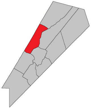
Northampton is a geographic parish in Carleton County, New Brunswick, Canada, sitting across the Saint John River from Woodstock.

<span class="mw-page-title-main">Brighton Parish, New Brunswick</span> Parish in New Brunswick, Canada

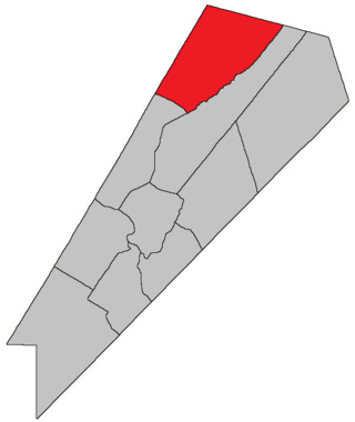
Brighton is a geographic parish in Carleton County, New Brunswick, Canada, northeast of Woodstock, extending from the eastern bank of the Saint John River to the York County line.

<span class="mw-page-title-main">Woodstock Parish, New Brunswick</span> Parish in New Brunswick, Canada

Woodstock is a geographic parish in Carleton County, New Brunswick, Canada, surrounding the town of the same name on its landward side.

<span class="mw-page-title-main">Prince William Parish, New Brunswick</span> Parish in New Brunswick, Canada

Prince William is a geographic parish in York County, New Brunswick, Canada.

<span class="mw-page-title-main">Maugerville Parish, New Brunswick</span> Parish in New Brunswick, Canada

Maugerville is a geographic parish in Sunbury County, New Brunswick, Canada.

<span class="mw-page-title-main">Lincoln Parish, New Brunswick</span> Parish in New Brunswick, Canada

Lincoln is a geographic parish in Sunbury County, New Brunswick, Canada.

<span class="mw-page-title-main">Northfield Parish, New Brunswick</span> Parish in New Brunswick, Canada

Northfield is a geographic parish in Sunbury County, New Brunswick, Canada.

<span class="mw-page-title-main">Saint Andrews Parish, New Brunswick</span> Parish in Canada

Saint Andrews Parish is a geographic parish in Charlotte County, New Brunswick, Canada, located east of St. Stephen.

<span class="mw-page-title-main">Westmorland Parish, New Brunswick</span> Parish in New Brunswick, Canada

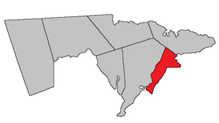
Westmorland is a geographic parish in Westmorland County, New Brunswick, Canada.

<span class="mw-page-title-main">Burton Parish, New Brunswick</span> Parish in New Brunswick, Canada

Burton is a geographic parish in Sunbury County, New Brunswick, Canada.

<span class="mw-page-title-main">Gagetown Parish, New Brunswick</span> Parish in New Brunswick, Canada

Gagetown is a geographic parish in Queens County, New Brunswick, Canada.

<span class="mw-page-title-main">Canning Parish, New Brunswick</span> Parish in New Brunswick, Canada

Canning is a geographic parish in Queens County, New Brunswick, Canada.

<span class="mw-page-title-main">Chipman Parish, New Brunswick</span> Parish in New Brunswick, Canada

Chipman is a geographic parish in Queens County, New Brunswick, Canada.

<span class="mw-page-title-main">Wickham Parish, New Brunswick</span> Parish in New Brunswick, Canada

Wickham is a geographic parish in Queens County, New Brunswick, Canada.

<span class="mw-page-title-main">Pennfield Parish, New Brunswick</span> Parish in Canada

Pennfield is a geographic parish in Charlotte County, New Brunswick, Canada, located west of Saint John located east of St. George and west of Saint John.

<span class="mw-page-title-main">Saint Stephen Parish, New Brunswick</span> Parish in Canada

Saint Stephen is a geographic parish in Charlotte County, New Brunswick, Canada, located in the southwestern corner of the province.

References

  1. 1 2 "Census Profile". Statistics Canada. 26 October 2022. Retrieved 30 October 2022.
  2. 1 2 "Chapter T-3 Territorial Division Act". Government of New Brunswick. Retrieved 13 November 2020.
  3. "New Brunswick Regulation 84-168 under the Municipalities Act (O.C. 84-582)". Government of New Brunswick. Retrieved 22 July 2020.
  4. "Communities in each of the 12 Regional Service Commissions (RSC) / Les communautés dans chacune des 12 Commissions de services régionaux (CSR)" (PDF), Government of New Brunswick, July 2017, retrieved 2 February 2021
  5. Ganong, William F. (1896). A Monograph of the Place-Nomenclature of the Province of New Brunswick. Royal Society of Canada. p. 272. Retrieved 17 March 2021. William Francis Ganong cites Footprints by J. W. Lawrence as his source.
  6. "26 Geo. III Chapter I. An Act for the better ascertaining and confirming the Boundaries of the several Counties within this Province, and for subdividing them into Towns or Parishes.". Acts of the General Assembly of His Majesty's Province of New-Brunswick, passed in the year 1786. Saint John, New Brunswick: Government of New Brunswick. 1786. pp. 3–12. Retrieved 20 March 2021.
  7. "13 Vic. c. 51 An Act to consolidate all the Laws now in force for the division of the Province into Counties, Towns and Parishes.". Acts of the General Assembly of Her Mjaesty's Province of New Brunswick, Passed in the Year 1850. Fredericton: Government of New Brunswick. 1850. pp. 142–152, 145–149. Retrieved 27 March 2021. Book was poorly proofread, resulting in title typo and reuse of page numbers 145–152.
  8. "18 Vic. c. 37 An Act to Regulate the Election of Members to serve in the General Assembly.". Acts of the General Assembly of Her Majesty's Province of New Brunswick, Passed in the Month of November, 1854, and in the Months of February, March, and April, 1855. Fredericton: Government of New Brunswick. 1855. pp. 127–150. Available as a free ebook from Google Books.
  9. "20 Vic. c. 11 An Act to authorize the division of the Parish of Sheffield into two Parishes.". Acts of the General Assembly of Her Majesty's Province of New Brunswick, Passed in July 1856, and March and July 1857. Fredericton: Government of New Brunswick. 1857. pp. 16–17. Retrieved 27 March 2021.
  10. 1 2 3 4 5 "No. 115". Provincial Archives of New Brunswick. Department of Natural Resources and Energy Development. Retrieved 22 June 2021. Remainder of parish on maps 116, 127, and 128 at same site.
  11. 1 2 3 4 5 "330" (PDF). Transportation and Infrastructure. Government of New Brunswick. Retrieved 22 June 2021. Remainder of parish on mapbooks 331, 351, 352, 372, 373, 391, and 392 at same site.
  12. 1 2 3 4 "Search the Canadian Geographical Names Database (CGNDB)". Government of Canada. Retrieved 3 July 2021.
  13. "New Brunswick Regulation 94-43 under the Fish and Wildlife Act (O.C. 94-231)". Government of New Brunswick. 5 June 2006. Retrieved 8 July 2021.
  14. "Explore New Brunswick's Protected Natural Areas". GeoNB. Retrieved 3 July 2021.
  15. Statistics Canada: 2001, 2006 census
  16. 2011 Statistics Canada Census Profile: Sheffield Parish, New Brunswick
  17. 1 2 "Census Profile, 2016 Census: Sheffield, Parish [Census subdivision], New Brunswick". Statistics Canada. Retrieved 29 August 2019.
  18. Atlantic Canada Back Road Atlas ISBN   978-1-55368-618-7


45°59′44″N66°13′21″W / 45.9955°N 66.2224°W / 45.9955; -66.2224