Saitama Prefecture is a prefecture of Japan located in the Kantō region. The capital is the city of Saitama.
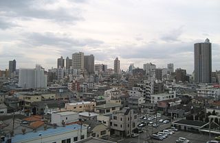
Kawaguchi is a city located in Saitama Prefecture, Japan. As of 1 March 2018, the city had an estimated population of 600,388, and a population density of 9,691.49 persons per km². Its total area is 61.95 square kilometres (23.92 sq mi). It is the Greater Tokyo Area's 8th most populated city, and second largest in Saitama Prefecture.

Musashimurayama is a city located in the western side of Tokyo, Japan. As of 1 February 2016, the city had an estimated population of 70,694, and a population density of 4,610 people per km². The total area of Musashimurayama is 15.32 square kilometres (5.92 sq mi).
Arakawa (荒川) may refer to:

Ōmiya is one of ten wards of the city of Saitama, in Saitama Prefecture, Japan, and is located in the northeastern part of the city. As of 1 February 2016, the ward had an estimated population of 113,742 and a population density of 8,890 persons per km². Its total area was 12.80 square kilometres (4.94 sq mi). Although Urawa-ku is the governmental center of Saitama City, Ōmiya-ku is the most active commercial and business centre in both Saitama City and Saitama Prefecture thanks to its transport infrastructure, especially railways connected at Ōmiya Station.
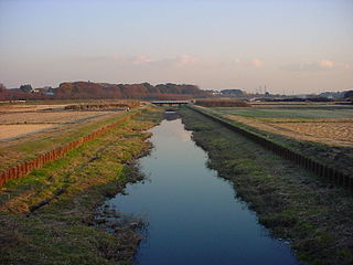
The Iruma River, is a river in Saitama Prefecture, Japan. It is 63 kilometres (39 mi) long and has a watershed of 721 square kilometres (278 sq mi). The river rises from Mount Ōmochi in Hannō, Saitama and flows to the Arakawa River at Kawagoe, Saitama.

The Mologa is a river in Maksatikhinsky, Bezhetsky, Lesnoy, and Sandovsky Districts of Tver Oblast, Pestovsky District in Novgorod Oblast, and Ustyuzhensky and Cherepovetsky Districts in Vologda Oblast Russia. It is a left tributary of the Volga River. The lower course of the Mologa has been turned into the Rybinsk Reservoir. It is 456 kilometres (283 mi) long, and the area of its basin 29,700 square kilometres (11,500 sq mi). The principal tributaries of the Mologa are the Osen (right), the Volchina (left), the Kobozha (left), the Chagodoshcha (left) and the Sit.

A body of water or waterbody is any significant accumulation of water, generally on a planet's surface. The term most often refers to oceans, seas, and lakes, but it includes smaller pools of water such as ponds, wetlands, or more rarely, puddles. A body of water does not have to be still or contained; rivers, streams, canals, and other geographical features where water moves from one place to another are also considered bodies of water.

The Arakawa River is a 173-kilometre (107 mi) long river that flows through Saitama Prefecture and Tokyo.

A reservoir is a storage space for fluids. These fluids may be water, hydrocarbons or gas. A reservoir usually means an enlarged natural or artificial lake, storage pond or impoundment created using a dam or lock to store water. Reservoirs can be created by controlling a stream that drains an existing body of water. They can also be constructed in river valleys using a dam. Alternately, a reservoir can be built by excavating flat ground or constructing retaining walls and levees. Tank reservoirs store liquids or gases in storage tanks that may be elevated, at grade level, or buried. Tank reservoirs for water are also called cisterns.

Saitama is the capital and the most populous city of Saitama Prefecture, Japan. Its area incorporates the former cities of Urawa, Ōmiya, Yono and Iwatsuki. It is a city designated by government ordinance. Being in the Greater Tokyo Area and lying 15 to 30 kilometres north of central Tokyo, many of its residents commute into Tokyo. As of 1 February 2016, the city had an estimated population of 1,226,656, and a population density of 5830 persons per km². Its total area is 217.43 square kilometres (83.95 sq mi).

Minuma-ku is one of ten wards of the city of Saitama, in Saitama Prefecture, Japan, and is located in the northern part of the city. As of 1 February 2016, the ward had an estimated population of 87,513 and a population density of 3010 persons per km². Its total area was 29.14 square kilometres (11.25 sq mi).
Ōmiya was a city located in Saitama Prefecture, Japan.

Midori-ku is one of ten wards of the city of Saitama, in Saitama Prefecture, Japan, and is located in the southeastern part of the city. As of 1 February 2016, the ward had an estimated population of 117,152 and a population density of 4,430 persons per km². Its total area was 26.44 square kilometres (10.21 sq mi).

Minuma Tsūsen-bori (見沼通船堀) is a lock that connected Minuma Irrigation Canal and the Shiba River. It was constructed in 1731. It served a significant role in transportation from the latter half of the Edo period till the end of the Meiji period, but it has not been used since 1931. The restored structure is located in Midori-ku, Saitama.
Kosasthalaiyar River, also known as Kortalaiyar, is one of the three rivers that flow in the Chennai metropolitan area.
The Arakawa River is a river in Fukushima, Fukushima, Japan.
Arakawa River (荒川) or Ara River may refer to:

Toda is a city located in Saitama Prefecture, Japan. As of 1 February 2016, the city had an estimated population of 136,652, and a population density of 7510 persons per km². Its total area is 18.19 square kilometres (7.02 sq mi).