
Manicaland is a province in eastern Zimbabwe. After Harare Province, it is the country's second-most populous province, with a population of 1.75 million, as of the 2012 census. After Harare and Bulawayo provinces, it is Zimbabwe's third-most densely populated province. Manicaland was one of five original provinces established in Southern Rhodesia in the early colonial period. The province is divided into ten administrative subdivisions of seven rural districts and three towns/councils, including the provincial capital, Mutare. The name Manicaland is derived from the province's largest ethnic group, the Manyika, a Shona subgroup who speak a distinct Shona dialect, Manyika.
Goromonzi District is a district of Mashonaland East Province, Zimbabwe, in southern Africa. It is located in the eastern part of Zimbabwe, and covers an area of approximately 3,500 square miles (9,100 km2). As of the 2012 census it had a population of 224,987, up from 154,262 in the 2002 census. The people who live in the region are principally from the Shona tribe.
Mudzi East is a parliamentary constituency in Mashonaland, Zimbabwe. In 2005 it was one of the three constituencies in Mudzi district, the other two being Mudzi West and Mudzi Central. Mudzi East is a rural area.
Mudzi West is a constituency of Zimbabwe. It belongs to Mudzi District in East Mashonaland, and comprises the Shanga, Suswe, Mudzi, Musarakufa and Chiunye areas. It is a rural area.

Sanyati is a town in Zimbabwe.

}
Zhombe is a rural communal area in Kwekwe District, Midlands Province, Zimbabwe. There are a few commercial farms within its borders and a handful of resettlement areas. Most of it is within the Zhombe Constituency. Its administrative centre is the Zhombe Joel Growth Point, and it is under the Zibagwe Rural District Council.
Nyamapanda is a town in the Mashonaland East Province of northern Zimbabwe. It is a border post for crossing between Zimbabwe and Mozambique. The border post on the Mozambique side is Cochemane. Nyamapanda is at an altitude of 579 metres (1,900 ft). A dam on the Nyamapande River just upstream from the town provides for irrigation.
Mutoko is a small town in Mashonaland East province, Zimbabwe. It was established as an administrative station in 1911. It lies 143 km from Harare. It is named after the local Chief Mutoko.
Goromonzi is a rural community in East Mashonaland, Zimbabwe, 20 miles (32 km) southeast of the country's capital city of Harare. The people are principally from the Shona tribe. The village serves as a trading centre for commercial, communal and co-operative farms. It is also the administrative centre for the Chinyika communal land and Goromonzi District. The community is located on a subsidiary road north of the A3 highway to Harare. Goromonzi Hill, at 1,581 metres (5,187 ft), is just southeast of the town.

Goromonzi West is a constituency in Zimbabwe. It was created in the delimitation of 2008 from the former Goromonzi constituency, and covers Makumbe, Parirewa, Domboshava and Makumbe Mission. As of 2013, it elected one representative to the House of Assembly. In the March 2008 parliamentary election the seat was won by the ZANU-PF candidate who defeated the MDC candidate from the Morgan Tsvangirai faction (MDC-T) by just 262 votes. In the 2013 election the ZANU-PF candidate, Biata B. Nyamupinga, was again challenged by Ian Makone (MDC-T) as well as by Wonder Chinamora (MDC). Nyamupinga retained her seat in the Assembly. A recount in Goromonzi West was conducted in April 2008, increasing ZANU-PF's total by one vote, from 6,193 to 6,194.

Harare Metropolitan Province is a province in northeastern Zimbabwe. It comprises Harare, the country's capital and most populous city, and two other municipalities, Chitungwiza and Epworth. Originally part of Mashonaland Province, in 1983 the province was divided into three large provinces, Mashonaland Central, Mashonaland East, and Mashonaland West, while Harare and two nearby towns became their own metropolitan province. Harare Province is divided into four districts. Miriam Chikukwa is the current provincial governor.
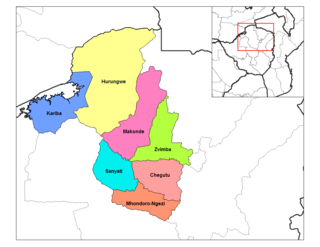
Zvimba District is a district of Mashonaland West Province, Zimbabwe.
Charles Charamba is a Zimbabwean gospel musician and a former pastor in the Apostolic Faith Mission Church of Zimbabwe (AFM). He has since started his church. Charamba's albums have been the top selling gospel music in Zimbabwe since the early 2000s. He has toured both Great Britain and the United States, and throughout southern Africa. One of Charamba's most famous songs is “Machira Chete”. His wife, Olivia, is also a gospel singer, and appears with him on stage and on his albums; they are often called the "First Family of Gospel".
Uzumba, formerly known as "Uzumba-Maramba-Pfungwe", is a district of Mashonaland East Province in Zimbabwe. It was split into Uzumba, Maramba, and Pfungwe. It consists of the northern part of the pre-1969 larger Murehwa (Mrehwa) District and includes the village of Uzumba. The area is inhabited by the Budja Shona people. The staple food crop is maize.
Mutoko District is a district of Mashonaland East Province, Zimbabwe, in southern Africa. It is located in the eastern part of Zimbabwe, and covers 4,092.5 square kilometres (1,580 sq mi). In 1992, the district had a population of 124,013. At that time nearly 50% of the population was under 15 years of age.
Marondera District is a district of Mashonaland East Province, Zimbabwe, in southern Africa. It is located in the eastern part of Zimbabwe, and covers an unknown area. The district capital is the town of Marondera, which is also the provincial capital.
Kotwa is a small town in Mudzi District, Mashonaland East province, Zimbabwe. It is the capital of the district, serving as its administrative and commercial centre.


