
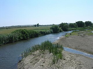
Simoeis or Simois [1] /ˈsɪmoʊɪs/ (Ancient Greek : ΣιμόειςSimóeis) was a river of the Trojan plain, now called the Dümruk Su (Dümrek Çayı), [2] and the name of its god in Greek mythology.
Simoeis or Simois [1] /ˈsɪmoʊɪs/ (Ancient Greek : ΣιμόειςSimóeis) was a river of the Trojan plain, now called the Dümruk Su (Dümrek Çayı), [2] and the name of its god in Greek mythology.
The Simoeis was a small river of the ancient Troad, having its source in Mount Ida, or more accurately in Mount Cotylus, which passed by Troy, joined the Scamander River below that city. This river is frequently spoken of in the Iliad , and described as a rapid mountain torrent. [3] The river is also noted by the ancient geographers Strabo, [4] Ptolemy, [5] Stephanus of Byzantium, [6] Pomponius Mela, [7] and Pliny the Elder. [8] Its present course is so altered that it is no longer a tributary of the Scamander, but flows directly into the Hellespont.
Like other river-gods, Simoeis was the son of Oceanus and Tethys. [9] Simoeis had two daughters who were married into the Trojan royal family. One daughter, Astyoche, was married to Erichthonius, and the other daughter, Hieromneme was the wife of Assaracus.
When the gods took sides in the Trojan War, Simoeis supported the Trojans. Scamander, another river who also supported the Trojans, called upon Simoeis for help in his battle against Achilles:
"Come to my aid with all speed, fill your streams with water from your springs, stir up all your torrents, stand high in a great wave, and rouse a mighty roar of timbers and rocks, so we can stop this savage manwho in his strength is raging like the gods." ( Iliad , 21.311-15).
Before Simoeis could respond, Hephaestus was able to save Achilles by subduing Scamander with flame.

Scamander, also Skamandros or Xanthos (Ξάνθος), was a river god in Greek mythology.
Karamenderes is a river located entirely within the Çanakkale Province of Turkey. It flows west from Mount Ida and empties into the Aegean Sea near the Troy Historical National Park. According to the Iliad, the battles of the Trojan War were fought in the lower courses of Karamenderes.
Cius, later renamed Prusias on the Sea after king Prusias I of Bithynia, was an ancient Greek city bordering the Propontis, in Bithynia and in Mysia, and had a long history, being mentioned by Herodotus, Xenophon, Aristotle, Strabo and Apollonius Rhodius.
Percote or Perkote was a town or city of ancient Mysia on the southern (Asian) side of the Hellespont, to the northeast of Troy. Percote is mentioned a few times in Greek mythology, where it plays a very minor role each time. It was said to be the home of a notable seer named Merops, also its ruler. Merops was the father of Arisbe, Cleite, and two sons named Amphius and Adrastus who fought during the Trojan War. As an ally of Troy, Percote sent a contingent to help King Priam during the Trojan War - though this contingent was led not by Merops's sons, but by Asius, son of Hyrtacus, according to Homer's Iliad, one native from Percote was wounded in the Trojan War by Antilochus, two natives from Percote were killed in the Trojan War by Diomedes and Ulysses. The Meropidae instead lead a contingent from nearby Adrastea. A nephew of Priam, named Melanippus, son of Hicetaon, herded cattle (oxen) at Percote, according to Homer.
Pagae or Pagai, or Pegae or Pegai was a town of ancient Megaris, on the Alcyonian or Corinthian Gulf. According to some sources of greek mythology Pagae had been the home town of Tereus. It was the harbour of Megaris on the western coast, and was the most important place in the country next to the capital. According to Strabo it was situated on the narrowest part of the Megaric isthmus, the distance from Pagae to Nisaea being 120 stadia. When the Megarians joined Athens in 455 BCE, the Athenians garrisoned Pagae, and its harbour was of service to them in sending out an expedition against the northern coast of Peloponnesus. The Athenians retained possession of Pagae a short time after Megara revolted from them in 454 BCE; but, by the thirty years' truce made in the same year, they surrendered the place to the Megarians. At one period of the Peloponnesian War (424 BCE) we find Pagae held by the aristocratical exiles from Megara. Pagae continued to exist until a late period, and under the Roman emperors was a place of sufficient importance to coin its own money. Strabo calls it τὸ τῶν Μεγαρέων φρούριον. Pausanias visited in the 2nd century and saw there a chapel of the hero Aegialeus, who fell at Glisas in the second expedition of the Argives against Thebes, but who was buried at this place. He also saw near the road to Pagae, a rock covered with marks of arrows, which were supposed to have been made by a body of the Persian cavalry of Mardonius, who in the night had discharged their arrows at the rock under the impulse of Artemis, mistaking it for the enemy. In commemoration of this event, there was a brazen statue of Artemis Soteira at Pagae. From 193 BCE Pagae was a member of the Achaean League. Pagae is also mentioned in other ancient sources, including Ptolemy, Stephanus of Byzantium, Pomponius Mela, Pliny the Elder, Hierocles, and the Tabula Peutingeriana, where it is called Pache.

The Potamoi are the gods of rivers and streams of the earth in Greek mythology.
Ialysus or Ialysos, also Ialyssus or Ialyssos (Ἰάλυσσος), or Ielyssus or Ielyssos (Ἰήλυσσος), was a city of ancient Rhodes. It was one of the three ancient Doric cities in the island, and one of the six towns constituting the Doric hexapolis. It was situated only six stadia to the south-west of the city of Rhodes, and it would seem that the rise of the latter city was the cause of the decay of Ialysus; for in the time of Strabo it existed only as a village. Pliny the Elder did not consider it as an independent place at all, but imagined that Ialysus was the ancient name of Rhodes. Orychoma, the citadel, was situated above Ialysus, and still existed in the time of Strabo. It is supposed by some that Orychoma was the same as the fort Achaea or Achaia, which is said to have been the first settlement of the Heliadae in the island; at any rate, Achaia was situated in the territory of Ialysus, which bore the name Ialysia. The city is mentioned by numerous ancient authors, including Pindar, Herodotus, Thucydides, Ptolemy, Stephanus of Byzantium, Ovid, and Pomponius Mela, Dionysius Periegetes, and appears in the Periplus of Pseudo-Scylax.

Halos, Latinised as Halus, was a town and polis in the region of Achaea Phthiotis in ancient Thessaly, on the west side of the Pagasetic Gulf.
Cynus was the principal sea-port of the Opuntian Locrians, situated on a cape at the northern extremity of the Opuntian Gulf, opposite Aedepsus in Euboea, and at the distance of 60 stadia from Opus. Livy gives an incorrect idea of the position of Cynus, when he describes it as situated on the coast, at the distance of a mile from Opus. Cynus was an ancient town, being mentioned in the Homeric Catalogue of Ships in the Iliad. It was reported to have been the residence of Deucalion and Pyrrha; the tomb of the latter was shown there. Beside Livy and Homer, Cynus is mentioned by other ancient authors, including Strabo, Pomponius Mela, Pliny the Elder, and Ptolemy.
Cypsela or Kypsela, was an ancient Greek town on the river Hebrus in ancient Thrace, which was once an important place on the Via Egnatia. Antiochus besieged Cypsela and its citizens surrendered and became allies with Antiochus.
Thynias was a town of ancient Thrace on the coast of the Pontus Euxinus on a promontory of the same name, mentioned by numerous ancient authors. It was located north of Salmydessus, which was probably at one time in the territories of the Thyni, although Strabo speaks of the district as belonging to the people of Apollonia. According to Pliny the Elder, the town was placed a little to the south of the promontory.
Caryanda or Karyanda was a city on the coast of ancient Caria in southwestern Anatolia. Stephanus of Byzantium describes it as a city and harbour (λίμην) near Myndus and Cos. But λιμήν, in the text of Stephanus, is an emendation or alteration: the manuscripts use the word λίμνη ('lake'). Strabo places Caryanda between Myndus and Bargylia, and he describes it, according to the common text, as "a lake, and island of the same name with it;" and thus the texts of Stephanus, who derived his information from Strabo, agree with the texts of Strabo. Pliny simply mentions the island Caryanda with a town; but he is in that passage only enumerating islands. In another passage he mentions Caryanda as a place on the mainland, and Pomponius Mela does so too. Scylax of Caryanda, one of the most famous mariners and explorers of ancient times, was a native of Caryanda. He lived in the late 6th and early 5th centuries BC and served the Persian king Darius I.
In Greek mythology, the name Xanthus or Xanthos may refer to:

Mesembria was an important Greek city in ancient Thrace. It was situated on the coast of the Euxine and at the foot of Mount Haemus; consequently upon the confines of Moesia, in which it is placed by Ptolemy. Strabo relates that it was a colony of Dorians from Megara, and that it was originally called Menebria (Μενεβρία) after its founder Menas; Stephanus of Byzantium says that its original name was Melsembria (Μελσημβρία), from its founder Melsas; and both writers state that the termination -bria was the Thracian word for town. According to the Anonymous Periplus of the Euxine Sea, Mesembria was founded by Chalcedonians at the time of the expedition of Darius I against Scythia; but according to Herodotus it was founded a little later, after the suppression of the Ionic Revolt, by fugitives from Byzantium and Chalcedon. These statements may, however, be reconciled by supposing that the Thracian town was originally colonized by Megarians, and afterwards received additional colonists from Byzantium and Chalcedon.
Canae was, in classical antiquity, a city in ancient Aeolis, on the island of Argennusa in the Aegean Sea off the modern Dikili Peninsula on the coast of modern-day Turkey, near the modern village of Bademli. Today Argennusa has joined the mainland as the Kane Promontory off the Dikili Peninsula. Canae is famous as the site of the Battle of Arginusae in 406 B.C.
Lilaea or Lilaia, also Lilaeum or Lilaion (Λίλαιον), was one of the most important ancient Phocian towns, and a polis (city-state), built on the north slopes of Mount Parnassus, and at the sources of the Cephissus.
Gyrton or Gyrtona or Gyrtone (Γυρτώνη) was a town and polis (city-state) of Perrhaebia in ancient Thessaly, situated in a fertile plain between the rivers Titaresius and Peneius. Strabo connects Gyrton with the mouth of the Peneius; but it is evident from the description of Livy, whose account has been derived from Polybius, that it stood in some part of those plains in which Phalanna, Atrax, and Larissa were situated. It was only one day's march from Phalanna to Gyrton. It was an ancient town even in Classical times, mentioned by Homer, and continued to be a place of importance till later times, when it is called opulent by Apollonius Rhodius. It was said to have been the original abode of the Phlegyae, and to have been founded by Gyrton, the brother of Phlegyas. Others say that it derived its name from Gyrtone, who is called a daughter of Phlegyas.
Meliboea or Meliboia was a town and polis (city-state) of Magnesia in ancient Thessaly, mentioned by Homer, in the Catalogue of Ships in the Iliad, as one of the places subject to Philoctetes. It was situated upon the sea coast, and is described by Livy as situated at the roots of Mount Ossa, and by Strabo as lying in the gulf between Mount Ossa and Mount Pelion.
Demetrium or Demetrion, was a town of Phthiotis in ancient Thessaly, whose name derived from a temple of Demeter near Pyrasus spoken of by Homer in the Iliad, and which Strabo describes as the successor settlement to, and two stadia distant from Pyrasus. Besides Strabo, Demetrium is mentioned by numerous ancient authors: in the Periplus of Pseudo-Scylax, by Livy, Pomponius Mela, and Stephanus of Byzantium.

Pygela or Phygela (Φύγελα) was a small town of ancient Ionia, on the coast of the Caystrian Bay, a little to the south of Ephesus. It is located near Kuşadası, Asiatic Turkey. The ruins are right down on Pygela Plaji, "Pygela Beach." They are obviously partly drowned.
![]() This article incorporates text from a publication now in the public domain : Smith, William, ed. (1854–1857). "Simois". Dictionary of Greek and Roman Geography . London: John Murray.
This article incorporates text from a publication now in the public domain : Smith, William, ed. (1854–1857). "Simois". Dictionary of Greek and Roman Geography . London: John Murray.