Simonds Parish, Saint John County, New Brunswick

Last updated

Simonds
Saint John County NB - Simonds Parish.png
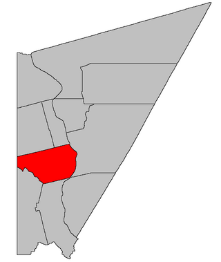
Location within Saint John County;
map erroneously includes City of Saint John within parish
Coordinates: 45°20′N65°47′W / 45.33°N 65.78°W / 45.33; -65.78
Country Flag of Canada (Pantone).svg  Canada
Province Flag of New Brunswick.svg  New Brunswick
County Saint John County
Erected1839
Area
[1]
  Land281.06 km2 (108.52 sq mi)
Population
 (2021) [1]
  Total3,913
  Density13.9/km2 (36/sq mi)
  Change 2016-2021
Increase2.svg 1.8%
  Dwellings
1,671
Time zone UTC-4 (AST)
  Summer (DST) UTC-3 (ADT)
Median Income*$51,323 CDN
  • Median household income, 2005 (all households)

Simonds is a geographic parish in Saint John County, New Brunswick, Canada. [4]

Contents

For governance purposes Simonds is divided between the village of Fundy-St. Martins [5] and the Fundy rural district, [6] both of which are members of the Fundy Regional Service Commission. [7]

Prior to the 2023 governance reform, the parish was divided for governance purposes between the local service districts of Fairfield and the parish of Simonds. [8] Fairfield and most of Simonds helped form Fundy-St. Martins, while the Red Head area of the Simonds LSD was assigned to the rural district. [lower-alpha 1]

Contrary to the map image on this page, Simonds does not and never has included the City of Saint John within its boundaries, although Saint John did annex part of Simonds in 1967. [9]

Origin of name

The parish may have been named in honour of Charles Simonds, Speaker of the House of Assembly when the parish was erected, or his family, who were prominent in the early history of the province. [10]

History

Simonds was erected in 1839 from Portland Parish. [11]

In 1902 an error in the boundaries of Saint John was corrected, returning part of Simonds. [12] The error occurred in 1889 when Saint John was amalgamated with Portland Parish and its boundary description was rewritten, [13] misstating the boundary at Drurys Cove.

In 1973 the territory annexed by Saint John in 1967 was formally removed in the revision of the Territorial Division Act. [14]

Boundaries

Simonds Parish is bounded: [2] [15] [16] [17]

Communities

Communities at least partly within the parish; [15] [16] [17] italics indicate a name no longer in official use

Bodies of water

Bodies of water [lower-alpha 2] at least partly in the parish: [15] [16] [17]

Islands

Islands in the parish: [15] [16] [17]

Other notable places

Parks, historic sites, and other noteworthy places in the parish. [15] [16] [17]

Demographics

Access Routes

Highways and numbered routes that run through the parish, including external routes that start or finish at the parish limits: [20]

See also

Notes

  1. Maps still visible as thumbnails show the current and previous governance boundaries. [5]
  2. Not including brooks, ponds or coves.

Related Research Articles

<span class="mw-page-title-main">Waterborough Parish, New Brunswick</span> Parish in New Brunswick, Canada

Waterborough is a geographic parish in Queens County, New Brunswick, Canada.

<span class="mw-page-title-main">Kingsclear Parish, New Brunswick</span> Parish in New Brunswick, Canada

Kingsclear is a geographic parish in York County, New Brunswick, Canada.

<span class="mw-page-title-main">Greenwich Parish, New Brunswick</span> Parish in New Brunswick, Canada

Greenwich is a geographic parish in Kings County, New Brunswick, Canada.

<span class="mw-page-title-main">Queensbury Parish, New Brunswick</span> Parish in New Brunswick, Canada

Queensbury is a geographic parish in York County, New Brunswick, Canada.

<span class="mw-page-title-main">Coverdale Parish, New Brunswick</span> Parish in New Brunswick, Canada

Coverdale is a geographic parish in Albert County, New Brunswick, Canada, located along the Petitcodiac River opposite Moncton and Dieppe.

<span class="mw-page-title-main">Simonds Parish, Carleton County, New Brunswick</span> Parish in New Brunswick, Canada

Simonds is a geographic parish in Carleton County, New Brunswick, Canada, located north of Woodstock on the western bank of the Saint John River.

<span class="mw-page-title-main">Wakefield Parish, New Brunswick</span> Parish in New Brunswick, Canada

Wakefield is a geographic parish in Carleton County, New Brunswick, Canada, located north on the west bank of the Saint John River north of Woodstock.

<span class="mw-page-title-main">Lincoln Parish, New Brunswick</span> Parish in New Brunswick, Canada

Lincoln is a geographic parish in Sunbury County, New Brunswick, Canada.

<span class="mw-page-title-main">Hillsborough Parish, New Brunswick</span> Parish in New Brunswick, Canada

Hillsborough is a geographic parish in eastern Albert County, New Brunswick, Canada.

<span class="mw-page-title-main">Hopewell Parish, New Brunswick</span> Parish in New Brunswick, Canada

Hopewell is a geographic parish in eastern Albert County, New Brunswick, Canada.

<span class="mw-page-title-main">Alma Parish, New Brunswick</span> Parish in New Brunswick, Canada

Alma is a geographic parish on the Bay of Fundy in the southwestern corner of Albert County, New Brunswick, Canada.

<span class="mw-page-title-main">Botsford Parish, New Brunswick</span> Parish in New Brunswick, Canada

Botsford is a geographic parish in Westmorland County, New Brunswick, Canada.

<span class="mw-page-title-main">Saint Martins Parish, New Brunswick</span> Parish in New Brunswick, Canada

Saint Martins is a geographic parish in Saint John County, New Brunswick, Canada.

<span class="mw-page-title-main">Musquash Parish, New Brunswick</span> Parish in New Brunswick, Canada

Musquash is a geographic parish in Saint John County, New Brunswick, Canada.

<span class="mw-page-title-main">Westfield Parish, New Brunswick</span> Parish in New Brunswick, Canada

Westfield is a geographic parish in Kings County, New Brunswick, Canada.

<span class="mw-page-title-main">Lepreau Parish, New Brunswick</span> Parish in Canada

Lepreau is a geographic parish in Charlotte County, New Brunswick, Canada, west of Saint John.

<span class="mw-page-title-main">Wickham Parish, New Brunswick</span> Parish in New Brunswick, Canada

Wickham is a geographic parish in Queens County, New Brunswick, Canada.

<span class="mw-page-title-main">Pennfield Parish, New Brunswick</span> Parish in Canada

Pennfield is a geographic parish in Charlotte County, New Brunswick, Canada, located west of Saint John located east of St. George and west of Saint John.

<span class="mw-page-title-main">West Isles Parish, New Brunswick</span> Parish in Canada

West Isles is a geographic parish in Charlotte County, New Brunswick, Canada.

<span class="mw-page-title-main">Saint George Parish, New Brunswick</span> Parish in Canada

Saint George is a geographic parish in Charlotte County, New Brunswick, Canada, located between St. Stephen and Saint John.

References

  1. 1 2 "Census Profile". Statistics Canada. 26 October 2022. Retrieved 30 October 2022.
  2. 1 2 "Chapter T-3 Territorial Division Act". Government of New Brunswick. Retrieved 16 April 2023.
  3. "Chapter I-13 Interpretation Act". Government of New Brunswick. Retrieved 16 April 2023.
  4. The Territorial Division Act [2] divides the province into 152 parishes, the cities of Saint John and Fredericton, and one town of Grand Falls. The Interpretation Act [3] clarifies that parishes include any local government within their borders.
  5. 1 2 "RSC 9 Fundy Regional Service Commission: RSC 9". Government of New Brunswick. Retrieved 16 April 2023.
  6. "RSC 9 Fundy Regional Service Commission RSC 9". Government of New Brunswick. Retrieved 16 April 2023.
  7. "Regions Regulation – Regional Service Delivery Act". Government of New Brunswick. 21 July 2022. Retrieved 16 April 2023.
  8. "New Brunswick Regulation 84-168 under the Municipalities Act (O.C. 84-582)". Government of New Brunswick. Retrieved 22 July 2020.
  9. "Regulation 66–52 under the Municipalities Act (O. C. 66–1053)". The Royal Gazette. 124. Fredericton: 649–650. 28 December 1966.
  10. Ganong, William F. (1896). A Monograph of the Place-Nomenclature of the Province of New Brunswick. Royal Society of Canada. p. 273. Retrieved 17 March 2021.
  11. "2 Vic. c. 15 An Act to erect the Eastern part of the Parish of Portland, in the County of Saint John, into a separate and distinct Town or Parish.". Acts of the General Assembly of Her Majesty's Province of New Brunswick, Passed in the Year 1839. Fredericton: Government of New Brunswick. 1839. p. 61. Retrieved 27 March 2021.
  12. "2 Edward 7 c. 29 An Act to amend Chapter 8 of 59 Victoria intituled 'An Act to revise and codify an Act to provide for the division of the Province into Counties, Towns and Parishes' for the purpose of re-establishing a correct line between the City of Saint John and the Parish of Simonds at Drury Cove (so called) in the City and County of Saint John.". Acts of the Legislative Assembly of His Majesty's Province of New Brunswick. Passed in the Month of April, 1902. Fredericton: Government of New Brunswick. 1902. pp. 102–103. Available as a free ebook from Google Books.
  13. "52 Vic. c. 27 An Act to unite the City of Portland with the City of Saint John, in the City and County of Saint John, and to amend the Charter of the City of Saint John, and the Law relating to Civic Government.". Acts of the General Assembly of Her Majesty's Province of New Brunswick. Passed in the Months of March and April, 1889. Fredericton: Government of New Brunswick. 1889. pp. 133–223. Available as a free ebook from Google Books.
  14. "Chapter T-3 Territorial Division Act". Revised Statutes of New Brunswick 1973 Volume IV. Fredericton: Government of New Brunswick. 1973. pp. 1–70. The original printed version is cited separately to distinguish it from the edited version available online.
  15. 1 2 3 4 5 "No. 157". Provincial Archives of New Brunswick. Department of Natural Resources and Energy Development. Retrieved 22 June 2021. Remainder of parish on maps 158 and 165 at same site.
  16. 1 2 3 4 5 "461" (PDF). Transportation and Infrastructure. Government of New Brunswick. Retrieved 22 June 2021. Remainder of parish on mapbooks 462, 474, 475, 485, 486, and 495 at same site.
  17. 1 2 3 4 5 "Search the Canadian Geographical Names Database (CGNDB)". Government of Canada. Retrieved 22 June 2021.
  18. Statistics Canada: 1986, 1991, 1996, 2001, 2006, 2011, 2016 census
  19. Profile: Simonds Parish, St John County, New Brunswick
  20. Atlantic Canada Back Road Atlas ISBN   978-1-55368-618-7