Athabasca is an anglicized version of the Cree name for Lake Athabasca in Canada, āthap-āsk-ā-w, meaning "grass or reeds here and there". Most places named Athabasca are found in Alberta, Canada.

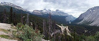
Jasper National Park, in Alberta, Canada, is the largest national park within Alberta's Rocky Mountains, spanning 11,000 km2 (4,200 sq mi). It was established as Jasper Forest Park in 1907, renamed as a national park in 1930, and declared a UNESCO world heritage site in 1984. Its location is north of Banff National Park and west of Edmonton. The park contains the glaciers of the Columbia Icefield, springs, lakes, waterfalls and mountains.

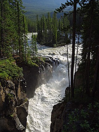
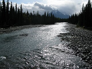
The Athabasca River is a river in Alberta, Canada, which originates at the Columbia Icefield in Jasper National Park and flows more than 1,231 km (765 mi) before emptying into Lake Athabasca. Much of the land along its banks is protected in national and provincial parks, and the river is designated a Canadian Heritage River for its historical and cultural importance. The scenic Athabasca Falls is located about 30 km (19 mi) upstream from Jasper.

Jasper is a specialized municipality and townsite in western Alberta within the Canadian Rockies. The townsite is in the Athabasca River valley and is the commercial centre of Jasper National Park.
The Sunwapta River is a major tributary of the Athabasca River in Jasper National Park in Alberta, Canada.
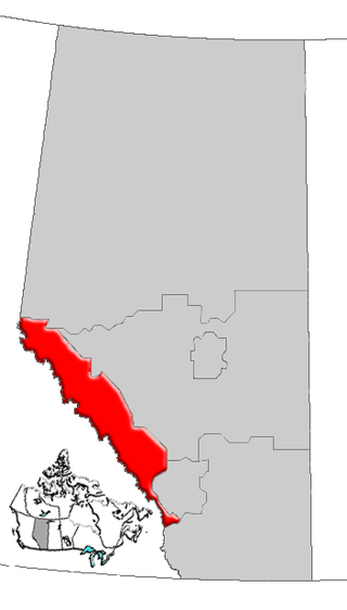
Alberta's Rockies comprise the Canadian Rocky Mountains in Alberta, Canada. On the southwestern part of the province along the British Columbia border, the region covers all but the south of Census Division 15.
Sunwapta Pass is a mountain pass in the Canadian Rockies in the province of Alberta. Sunwapta Pass is the low point of the saddle created between Mount Athabasca and Nigel Peak. The pass marks the boundary between Banff and Jasper National Parks. The Icefields Parkway travels through Sunwapta Pass 108 km (67 mi) southeast of the town of Jasper and 122 km (76 mi) northwest of the Parkway's junction with the Trans-Canada Highway near Lake Louise. The pass is the second highest point on the Icefields Parkway. Bow Summit in Banff National Park is the highest point on the parkway.
Mount Rutherford is a mountain in Jasper National Park in Alberta, Canada. It is part of the Northern Front Ranges of the Canadian Rockies. Its peak stands 3 km (2 mi) east of Harvey Lake and north of the Snaring River, a tributary of the Athabasca River.

The Chaba River is a short river in western Alberta, Canada. It flows from the Canadian Rockies, and joins the Athabasca River.

The Fiddle River is a medium-sized tributary of the Athabasca River, flowing into the river near the east gate of Jasper National Park in Alberta, Canada. The Fiddle River forms at the base of Fiddle Pass, with meltwater from Mount Bryant, Mount Gregg, Mount Sir Harold Mitchel, and Mount Barry. The river flows in a general northeast direction before its confluence with the Athabasca. The Fiddle River parallels the road to the popular Miette Hotsprings for a portion of its course.

The Miette River is a short river in Jasper National Park, Alberta, Canada. It flows south-southwest through the Rocky Mountains before draining eastward into the Athabasca River at Jasper.
The Maligne River is a medium-sized river in the Canadian Rockies. It runs through parts of Jasper National Park in Alberta, Canada. The Maligne is a major tributary of the Athabasca River.
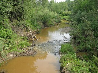
The Assineau River is a short river forming in central Alberta. The Assineau flows into Lesser Slave Lake, which flows out through the Lesser Slave River, a major tributary of the Athabasca River. The name for the river was in use by 1904. It is suggested that Assineau is a version of the Cree word for nobody.

The Driftpile River is a medium-length river forming in central Alberta. The Drifpile flows into Lesser Slave Lake, which flows out through the Lesser Slave River, a major tributary of the Athabasca River. The Geological Survey of Canada was using the name Driftpile by 1892. The river was named because of the large amount of driftwood that collected at the river's mouth.
The Marten River is a short river in central Alberta. The Marten is one of the major inflows of Lesser Slave Lake, which drains through the Lesser Slave River, a major tributary of the Athabasca River. Significant debate exists regarding the origin of the river's name. One theory suggests the river, as well as nearby Marten Mountain were named for a local trapper. The other theory suggests the river and mountain were named for martens, a weasel that inhabits the region. The Geological Survey of Canada used the name Martin River on an 1892 map.
The Jackpine River is an early tributary of the Smoky River. It forms in the Canadian Rockies, within Willmore Wilderness Park, in the province of Alberta, north of Jasper National Park. The river collects the runoff from Resthaven Mountain, Barricade Mountain, Jackpine Mountain, Mount Holmes, Perseverance Mountain, and Draco Peak.
The Muddywater River is an early tributary of the Smoky River. It forms in the Canadian Rockies, within Willmore Wilderness Park, in the province of Alberta, north of Jasper National Park. The Muddywater forms at Morkill Pass, on the Continental Divide between Alberta and British Columbia.

The Snake Indian River is a large tributary of the Athabasca River, exiting entirely within Jasper National Park. The Snake Indian forms at Snake Indian Pass, south of Monte Christo Mountain and Snake Indian Mountain, north of Calumet Peak. The river travels in a general northwest direction before turning sharply south. The river plummets over the massive Snake Indian Falls before joining the Athabasca River downstream of Jasper Lake, near the east gate of Jasper National Park.

The Astoria River is a short river in Jasper National Park, Alberta, Canada. It is an early tributary of the Athabasca River.
The Whirlpool River is a short river in Jasper National Park, Alberta, Canada. It is an early tributary of the Athabasca River.


