
Mascot is a suburb in the Inner-South of Sydney, in the state of New South Wales, Australia. Mascot is located 7 kilometres south of the Sydney central business district and is one of the administrative centres of the Bayside Council. A small part of Mascot is located in the Inner West Council. Mascot is on the north-west side of Botany Bay and contains Sydney Airport.

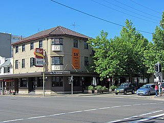
Bondi Junction is an eastern suburb of Sydney, in the state of New South Wales, Australia. It is 6 kilometres east of the Sydney central business district and is part of the local government area of Waverley.

The Eastern Suburbs & Illawarra Line is a commuter railway line in the eastern and southern suburbs of Sydney and is a part of the Sydney Trains network. The line was constructed in the 1880s to Wollongong to take advantage of agricultural and mining potentials in the Illawarra area. In March 1926, it became the first railway in New South Wales to run electric train services.

Randwick is a suburb of Sydney, in the state of New South Wales, Australia. Randwick is located 6 kilometres south-east of the Sydney central business district and is the administrative centre for the local government area of the City of Randwick. Randwick is part of the Eastern Suburbs of Sydney. The postcode is 2031.

The Eastern Suburbs is the eastern metropolitan region of Sydney, New South Wales, Australia.

The Sydney light rail network is a light rail/tram system serving the city of Sydney, New South Wales, Australia. The network currently consists of three passenger routes, the L1 Dulwich Hill, L2 Randwick and L3 Kingsford lines. The network comprises 42 stops and a system length of 24.7 km (15.3 mi), making it the second largest light rail network in Australia behind the tram network in Melbourne, Victoria. A fourth line, the 12 km (7.5 mi) Parramatta Light Rail in Sydney's west, is currently under construction and planned to open in May 2024.

The Eastern Suburbs Railway is a commuter railway line in Sydney constructed in the 1970s. It is operated by Sydney Trains and has stations at Martin Place, Kings Cross, Edgecliff and Bondi Junction. In addition, it has dedicated platforms at Town Hall, Central and Redfern stations. All of these stations are underground. The Eastern Suburbs railway connects with the Illawarra line at Erskineville, forming the Eastern Suburbs & Illawarra Line. The line features turnbacks at Central, Martin Place and Bondi Junction. There was also previously a rarely used cross-over or 'turnout' at Edgecliff. It operates a service every 3 to 5 minutes during weekday peak hours and 8 to 10 minutes at all other times.
Kingsford is a suburb in the Eastern Suburbs of Sydney, in the state of New South Wales, Australia. Kingsford is located 7 kilometres south-east of the Sydney central business district, in the local government area of the City of Randwick. Kingsford is part of the Eastern Suburbs region.

Kensington is a suburb in the Eastern Suburbs of Sydney, in the state of New South Wales, Australia. It is located 4 kilometres south-east of the Sydney central business district, in the local government area (LGA) of the City of Randwick, in the South-Eastern Suburbs region. Colloquially, Kensington is referred to as "Kenso", "Ensington" or "Enso".

Matraville is located in the South-Eastern Suburbs of Sydney, in the state of New South Wales, Australia. It is approximately 9 km (6 mi) by road south-east of the Sydney central business district, in the local government area of the City of Randwick.
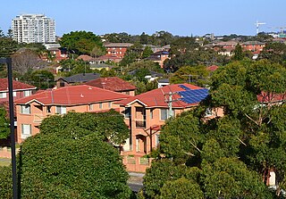
Eastlakes is an inner southern and south-eastern suburb of Sydney, in the state of New South Wales, Australia. Eastlakes is located 8 kilometres south of the Sydney central business district, in the local government area of the Bayside Council, Eastlakes is mostly residential with a shopping centre located at Evans Avenue. The residential portion of the suburb falls in the inner south being west of the Eastern Distributor while the non-residential side of the suburb consisting of the Lakes Gold Course is east of the Eastern Distributor falling in the south-east.
Hillsdale is a suburb in the Eastern Suburbs of Sydney, in the state of New South Wales, Australia. Hillsdale is located 6 kilometres south-east of the Sydney central business district in the Bayside Council. The suburb is named after Pat Hills, former Deputy Premier of New South Wales.

Sydney, the largest city in Australia, has an extensive network of passenger and freight railways. The passenger system includes an extensive suburban railway network, operated by Sydney Trains, a metro network and a light rail network. A dedicated freight network also exists. Future expansion of the light rail network includes the Parramatta Light Rail. Existing light rail services are the Inner West Light Rail and the CBD & South East Light Rail.

Anzac Parade is a major road in the south-eastern suburbs of Sydney, Australia. It included part of the marathon during the 2000 Summer Olympics, and the blue line denoting the marathon's path still exists today.
The Sydney Roosters Juniors are officially known as the Eastern Suburbs District Junior Rugby League. It is an affiliation of junior clubs in the Eastern Suburbs area, covering the Woollahra and Waverley local government areas (LGAs), the northern parts of the Randwick LGA and the City of Sydney LGA.
The metropolis of Sydney in New South Wales, Australia, is informally subdivided into a number of geographic regions. These areas sometimes, but not always, roughly coincide with official boundaries of suburbs, local government authorities, or cadastral units, and some of the customary regions do not have well defined boundaries at all. Some commonly referred to regions overlap: for example, Canterbury-Bankstown is often referred to as a region, but it is also part of the South Western Sydney region. The regions themselves are not used as a formal jurisdiction, and generally do not have administrative or legislative bodies, although some regions are coterminous with a local government area, and in a number of regions that include multiple local government areas, Regional Organisations of Councils have been established that represent the councils in the region.

Metrobus is a high frequency, high capacity bus network in Sydney, Australia. Metrobus services run every 10 minutes during peak periods, 15 minutes during off-peak weekday periods, and 20 minutes on weekends, linking key commercial suburbs and centres throughout the city, with the intention of making timetables obsolete. All buses were initially painted in a distinctive red livery but recently, the standard Transport for NSW livery of blue and white has been adopted. All Metrobus services are wheelchair accessible. All route numbers were prefixed with an "M" followed by a two-digit number.
Various railway lines have been proposed for Sydney, Australia, including both heavy rail extensions to the existing network, and more recently proposals for metro style lines–one of which was completed in 2019.
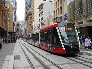
The CBD and South East Light Rail is a light rail line in Sydney, New South Wales, Australia. Construction commenced in October 2015, with services between Circular Quay and Randwick commencing on 14 December 2019 as the L2 Randwick Line, and between Circular Quay and Kingsford on 3 April 2020 as the L3 Kingsford Line. It is part of Sydney's light rail network.

Bayside Council is a southern local government area in New South Wales, Australia. It is located in Sydney, around part of Botany Bay, 7 kilometres (4.3 mi) to 12 kilometres (7.5 mi) south of the CBD. It includes suburbs of Southern Sydney and the St George area separated by the Cooks River as well as a small portion of South-Eastern Sydney. It comprises an area of 50 square kilometres (19 sq mi) and as at the 2016 census had a population of 156,058.
