The London Borough of Bromley is the southeasternmost of the 32 London boroughs that make up Greater London, bordering the county of Kent, which most of Bromley was part of before 1965. The borough's population is an estimated 332,336. It is named after Bromley, its principal town; other major towns are Penge, Hayes, West Wickham, Chislehurst, Beckenham and Orpington. The local authority is Bromley London Borough Council.

The London Borough of Barking and Dagenham is a London borough in East London. It lies around 9 miles (14.4 km) east of Central London. It is an Outer London borough and the south is within the London Riverside section of the Thames Gateway; an area designated as a national priority for urban regeneration. At the 2011 census it had a population of 187,000, the majority of which are within the Becontree estate. The borough's three main towns are Barking, Chadwell Heath and Dagenham. The local authority is Barking and Dagenham London Borough Council. Barking and Dagenham was one of six London boroughs to host the 2012 Summer Olympics.

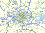
The London metropolitan area includes London and its surrounding commuter zone. It is also known as the London commuter belt, or Southeast metropolitan area.
The city of Mumbai, Maharashtra, India, is divided into administrative divisions. Greater Mumbai is the urban agglomeration of 18 million people which comes under the Municipal Corporation of Greater Mumbai. The Municipal Corporation of Greater Mumbai employs 140,626 people. The Corporation operates an annual budgetary outlay in excess of Rs. 30,000 Crores.

Rochford is a local government district in Essex, England. It is named for one of its main settlements, Rochford, though the major centre of population in the district is the town of Rayleigh. Other places in the district include Hockley, Ashingdon, Great Wakering, Canewdon and Hullbridge.
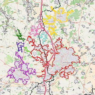
The Nottingham Built-up Area (BUA), Nottingham Urban Area, or Greater Nottingham is an area of land defined by the Office for National Statistics as which is built upon, with nearby areas linked if within 200 metres - see the List of urban areas in the United Kingdom article for a broader definition. It consists of the city of Nottingham and the adjoining urban areas of Nottinghamshire and Derbyshire, in the East Midlands of England. It had a total population of 729,977 at the time of the 2011 census. This was an increase of almost 10% since the 2001 census recorded population of 666,358, due to population increases, reductions and several new sub-divisions.
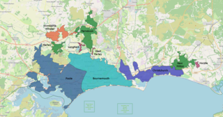
The South East Dorset conurbation is a multi-centred conurbation on the south coast of Dorset in England. The main population centres are Bournemouth, Christchurch and Poole, which together form the single unitary authority of Bournemouth, Christchurch and Poole; however, the urbanised area spreads into the Dorset unitary authority and into the New Forest District as far east as Barton on Sea. There are a number of satellite towns peripheral to these main urban centres. In clockwise rotation these include: Wareham, Verwood and Ringwood (Hampshire). The urban area is generally surrounded by a green belt.

The West Yorkshire Built-up Area, previously known as the West Yorkshire Urban Area is a term used by the Office for National Statistics (ONS) to refer to a conurbation in West Yorkshire, England, based on the cities of Leeds, Bradford and Wakefield, and the large towns of Huddersfield and Halifax which are part of the 4th largest urban areas in the United Kingdom. However, it excludes other large towns and suburbs such as Castleford, Pontefract and Wetherby which, though part of the county of West Yorkshire are considered independently. There are substantial areas of agricultural land within the designated area – more than in any other official urban area in England – many of the towns and cities are only just connected with one another by narrow outlying strips of development.

Farnborough/Aldershot built-up area and Aldershot Urban Area are names used by the ONS to refer to the quite loose conurbation spanning the borders of Surrey, Berkshire and Hampshire in England. The ONS found a population of 252,937 in 2011. This makes it the 29th-largest built up area in England and Wales.
The Reading/Wokingham Urban Area is a name given by the Office for National Statistics to a conurbation in Berkshire, England, with a population of 318,014. This was a significant decrease from the population according to the 2001 census of 369,804 due to Bracknell no longer being considered part of the built-up area, but forming part of the Greater London Urban Area instead.

Rayleigh and Wickford is a constituency represented in the House of Commons of the UK Parliament since its 2010 creation by Mark Francois, a Conservative.
The Leicester Urban Area or Leicester Built Up Area is an urban agglomeration defined by the Office of National Statistics (ONS), centred on the City of Leicester in the English Midlands. With a population of 508,916 at the time of the 2011 census, the Built Up Area is the eleventh largest in England and thirteenth largest in the United Kingdom. It comprises Leicester itself and its suburbs, all of which are contiguous with, or situated in close proximity to, the city.

The Sheffield Urban Area is a conurbation in the North of England with a population of 685,368 according to the 2011 census. This was a 7% increase on the 2001 population of 640,720 making it the 8th largest conurbation in the United Kingdom and England's 6th largest. Named the Sheffield Urban Area by the Office for National Statistics, it must not be confused with the Sheffield City Region, a non-government term, although often used, particularly by the business community. In 2001 the population density of the urban area was 3,949.2 people per km2 by 2011 this had increased slightly to 4,092 people per km2.

The Blackpool Built-up Area or Blackpool Urban Area is an urban area in Lancashire, England, consisting of the large town of Blackpool along with several surrounding towns and villages. Defined by the ONS it had a population of 239,409 in 2011 this is considerably down on the 2001 population of 261,088 mainly due to Fleetwood no longer being considered as part of the built-up area. The population of the Blackpool Urban Area has been declining for some time with the 2001 population down 0.1% from the 1991 figure of 261,355.

Chalkwell is an area in the Southend-on-Sea borough and unitary district in Essex, England. It forms part of the built-up area of Southend-on-Sea and is included in the Westcliff-on-Sea post town.
The Luton/Dunstable Urban Area, according to the Office for National Statistics, is the conurbation including the settlements of Luton, Dunstable and Houghton Regis, in Bedfordshire, East of England.

Hullbridge Sports Football Club is a football club based in Hullbridge, Essex, England. They are currently members of the Isthmian League North Division and play at Lower Road. The club runs over 25 teams from under-6 through to men's senior football.
Southend High School for Girls is a grammar school with academy status situated on Southchurch Boulevard in the east of Southend-on-Sea, Essex, England. It caters for students from the age of 11 through to 18 years old.
The Swansea Urban Area or Swansea Built-up Area is an area of land in south Wales, defined by the Office for National Statistics for population monitoring purposes. It is an urban conurbation and is not coterminous with the City and County of Swansea. It consists of the urban area centred on Swansea city centre; the Swansea Valley including Clydach, Ystradgynlais and Pontardawe; and includes Neath and Port Talbot which lay outside the county boundaries, but excludes the urban area of Gorseinon within the county boundaries.

The High Wycombe Urban Area is defined by the Office for National Statistics as a conurbation is southern Buckinghamshire. It had a population of 133,204 at the 2011 census. The area had a population of 118,229 at the 2001 census. The largest population centre is High Wycombe itself at 120,000.