
Holy Island is an island on the western side of the larger Isle of Anglesey, Wales, from which it is separated by the Cymyran Strait. It is called "Holy" because of the high concentration of standing stones, burial chambers and other religious sites on the small island. The alternative English name of the island is Holyhead Island. According to the 2011 UK Census, the population was 13,659, of whom 11,431 (84%) lived in the largest town, Holyhead.

Beaumaris is a town and community on the Isle of Anglesey in Wales, of which it is the former county town. It is located at the eastern entrance to the Menai Strait, the tidal waterway separating Anglesey from the coast of North Wales. At the 2021 census, its population was 1,121. The community includes Llanfaes.

Bodedern is a village and community in the west of Anglesey, Wales. At the 2001 census, it had a population of 1,074, decreasing slightly to 1,051 at the 2011 census. The community includes the settlements of Llanllibio and Pen-llyn.

Ynys Llanddwyn is a small tidal island off the west coast of Anglesey, northwest Wales. The nearest settlement is the village of Newborough.

Moelfre ( ) is a village, a community and, until 2012, an electoral ward on the north-east coast of the Isle of Anglesey in Wales. The community area covers the village and harbour, and several smaller, dispersed settlements. It includes six scheduled Iron Age hut groups and many other sites of archaeological interest. The harbour was formerly a local fishing port; a lifeboat station has been based here since 1854. Among many shipwrecks off the coast was that of the Royal Charter in 1859. Near the modernised lifeboat station is the RNLI Seawatch Centre. The coastline includes a rocky headland north of the village and a large sandy beach at Lligwy Bay, both traversed by the Anglesey Coastal Path. The 2011 census measured the village population as 710. It was estimated at 614 in 2019.

Trearddur or Trearddur Bay is a village, seaside resort and community south of Holyhead on the west coast of Holy Island off the north-west coast of Anglesey in Wales. The community includes the small settlement of Penrhosfeilw and the Refail Farm estate.

Seiriol was an early 6th-century saint, who created a cell at Penmon Priory on Anglesey, off the coast of north Wales. He later moved to Ynys Seiriol.
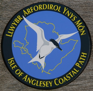
The Anglesey Coastal Path is a 200-kilometre (124 mi) long-distance footpath around the island of Anglesey in North Wales. The route is part of the Wales Coast Path.

Saint Cybi (Welsh), or Cuby (Cornish), was a 6th-century Cornish bishop, saint, and, briefly, king, who worked largely in Cornwall and North Wales: his biography is recorded in two slightly variant medieval 'lives'.

Llanbadrig is a village and community in Anglesey, Wales. The parish includes the township of Clygyrog, Tregynrig and the port of Cemaes, and was formerly in the cwmwd of Talybolion. The area has extensive quarries of limestone and marble. At the 2001 census it had a population of 1,392, reducing slightly to 1,357 at the 2011 census.

Rhoscolyn is a village and community located on Holy Island, Anglesey, Wales. It is just over five miles south of Holyhead and is the most southerly settlement on the island. The name Rhoscolyn is said to mean "The Moor" (Rhos) of The Column (colyn), referring to a pillar which the Romans put up to mark the edge of their territories. The community population taken from the 2011 census was 542.

Anglesey is an island off the north-west coast of Wales. It forms the bulk of the county known as the Isle of Anglesey, which also includes Holy Island and some islets and skerries. The county borders Gwynedd across the Menai Strait to the southeast, and is otherwise surrounded by the Irish Sea. Holyhead is the largest town, and the administrative centre is Llangefni. The county is part of the preserved county of Gwynedd. Anglesey is the northernmost county in Wales.
Llangybi(English: Cybi's Church) is a village and former civil parish in the Eifionydd area of the Welsh county of Gwynedd, near Llanarmon. The parish was abolished in 1934 and divided between Llanystumdwy and Llannor.

St Ffinan's Church, Llanffinan is a small 19th-century parish church built in the Romanesque revival style, in Anglesey, north Wales. There has been a church in this area, even if not on this precise location, since at least 1254, and 19th-century writers state that St Ffinan established the first church here in the 7th century. The church was rebuilt in 1841, reusing a 12th-century font and 18th-century memorials, as well as the cross at the eastern end of the roof.

Llaneilian is a village and community in Anglesey, Wales. It is located in the north east of the island, 2.2 miles (3.5 km) east of Amlwch, 16.5 miles (26.6 km) north west of Menai Bridge and 12.5 miles (20.1 km) north of Llangefni. The community includes the villages and hamlets of Dulas, Llaneilian, Pengorffwysfa, Cerrig Man and Penysarn, Gadfa and Nebo, and at the 2001 census had a population of 1,192, decreasing slightly to 1,186 at the 2011 Census. The parish is crowned by its hill, Mynydd Eilian, a HuMP, popular with walkers and ramblers, and its beach, Traeth Eilian, which is popular with holidaymakers and for watersport activities. At the north easternmost point is Point Lynas,, while Ynys Dulas lies off the North East coast of the island, east of Dulas Bay.

Llanbedrgoch is a hamlet and post town, a mile south of the town of Benllech and west of Red Wharf Bay, on the island of Anglesey, north Wales. The parish church is St Peter's Church, Llanbedrgoch, a Grade II* listed building that dates back to the 15th century.
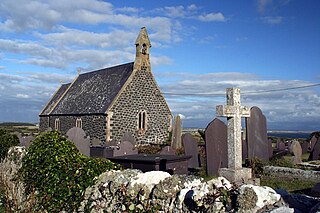
St Gwenfaen's Church is in the village of Rhoscolyn, on the Isle of Anglesey, Wales. The church was established in AD630, and was dedicated to St. Gwenfaen. The current church was erected in the Gothic-revival style, replacing the earlier building. It "was built in 1875 and enlarged by the addition of a chancel in 1879 ... the architect is thought to have been Sir George Gilbert Scott." It was designated as a Grade II listed building on 4 May 1971, as "a good example of a rural parish church, the simple Gothic style appropriate to its scale and site, and with rich interior fittings." These include "a fine C20 memorial of copper, with Art Nouveau styled design, to the Rector the Revd. John Hopkins, d.1901."
Ynys Gybi is the name of an electoral ward in the west of Anglesey, Wales, created in 2012. It covers the most part of Holy Island, whose name is Ynys Gybi in Welsh.


