Stamps, Arkansas | |
---|---|
Coordinates: 33°21′29″N93°30′01″W / 33.35806°N 93.50028°W | |
Country | United States |
State | Arkansas |
County | Lafayette |
Area | |
• Total | 3.15 sq mi (8.17 km2) |
• Land | 3.05 sq mi (7.91 km2) |
• Water | 0.10 sq mi (0.26 km2) |
Elevation | 262 ft (80 m) |
Population (2020) | |
• Total | 1,258 |
• Density | 412.19/sq mi (159.12/km2) |
Time zone | UTC−6 (Central (CST)) |
• Summer (DST) | UTC−5 (CDT) |
ZIP Code | 71860 |
Area code | 870 |
FIPS code | 05-66320 |
GNIS feature ID | 2405518 [2] |
Stamps is a city in Lafayette County, Arkansas, United States. The population was 1,693 at the 2010 census, [3] down from 2,131 at the 2000 census.
A post office has been in operation in Stamps since 1887. [4] The community has the name of the local Stamps family. [5] Stamps was the shop headquarters for the former Louisiana and Arkansas Railway until the relocation in the early 1920s to Minden in Webster Parish in northern Louisiana. [6]
Stamps has been noted on lists of unusual place names. [7] An early postmaster quipped that Stamps was "the only town in the U.S. that stamps Stamps on stamps". [7]
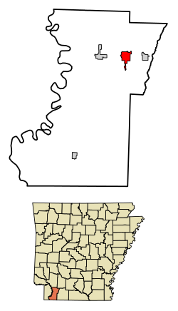
Stamps is in northeastern Lafayette County in southwestern Arkansas. U.S. Route 82 passes through the northern side of the city, leading west 5 miles (8 km) to Lewisville, the county seat, and east 3 miles (5 km) to Buckner. Arkansas Highway 53 has its northern terminus at US 82 and leads south through the center of Stamps 27 miles (43 km) to the state line near Springhill, Louisiana.
According to the United States Census Bureau, the city has a total area of 3.1 square miles (8.1 km2), of which 3.1 square miles (7.9 km2) are land and 0.1 square miles (0.3 km2), or 3.19%, are water. [3] Lake June lies within the southern part of the city limits.
Census | Pop. | Note | %± |
---|---|---|---|
1900 | 1,021 | — | |
1910 | 2,316 | 126.8% | |
1920 | 2,564 | 10.7% | |
1930 | 2,705 | 5.5% | |
1940 | 2,405 | −11.1% | |
1950 | 2,552 | 6.1% | |
1960 | 2,591 | 1.5% | |
1970 | 2,448 | −5.5% | |
1980 | 2,859 | 16.8% | |
1990 | 2,478 | −13.3% | |
2000 | 2,131 | −14.0% | |
2010 | 1,693 | −20.6% | |
2020 | 1,258 | −25.7% | |
U.S. Decennial Census [8] |
Race | Number | Percentage |
---|---|---|
White (non-Hispanic) | 485 | 38.55% |
Black or African American (non-Hispanic) | 693 | 55.09% |
Native American | 6 | 0.48% |
Asian | 6 | 0.48% |
Other/Mixed | 44 | 3.5% |
Hispanic or Latino | 24 | 1.91% |
As of the 2020 United States census, there were 1,258 people, 657 households, and 378 families residing in the city.
As of the census [10] of 2000, there were 2,131 people, 830 households, and 541 families residing in the town. The population density was 693.7 inhabitants per square mile (267.8/km2). There were 1,003 housing units at an average density of 326.5 per square mile (126.1/km2). The racial makeup of the city was 44.30% White, 54.48% Black or African American, 0.52% Native American, 0.09% Asian, 0.05% Pacific Islander, and 0.56% from two or more races. Of the population 0.61% was Hispanic or Latino of any race.
There were 830 households, out of which 30.7% had children under the age of 18 living with them, 37.8% were married couples living together, 21.7% had a female householder with no husband present, and 34.7% were non-families. Of all households 31.7% were made up of individuals, and 17.6% had someone living alone who was 65 years of age or older. The average household size was 2.46 and the average family size was 3.10.
In the city, the population was spread out, with 27.1% under the age of 18, 9.1% from 18 to 24, 23.7% from 25 to 44, 20.6% from 45 to 64, and 19.5% who were 65 years of age or older. The median age was 37 years. For every 100 females, there were 87.6 males. For every 100 females age 18 and over, there were 77.6 males.
The median income for a household in the town was $22,194, and the median income for a family was $26,591. Males had a median income of $25,667 versus $17,125 for females. The per capita income for the city was $11,440. About 22.8% of families and 27.8% of the population were below the poverty line, including 31.0% of those under age 18 and 24.2% of those age 65 or over.
Public education for elementary and secondary students is provided by the Lafayette County School District, which includes Lafayette County Elementary School and Lafayette County High School. The school's mascot and athletic emblem is the Cougar.
On July 1, 2003, the Stamps School District consolidated with the Lewisville School District to form the Lafayette County district. [11]
Coshocton County is a county located in the U.S. state of Ohio. As of the 2020 census, the population was 36,612. Its county seat and largest city is Coshocton. The county lies within the Appalachian region of the state. The county was formed on January 31, 1810, from portions of Muskingum and Tuscarawas Counties and later organized in 1811. Its name comes from the Delaware Indian language and has been translated as "union of waters" or "black bear crossing". Coshocton was mentioned by David Zeisberger in his diary from the 1780s using the German spelling "Goschachgünk". The Coshocton, OH Micropolitan Statistical Area includes all of Coshocton County.
Union County is a county located on the central southern border of the U.S. state of Arkansas. As of the 2020 census, the population was 39,054. The county seat is El Dorado. The county was formed on November 2, 1829, and named in recognition of the citizens' petition for a new county, which said that they were petitioning "in the spirit of Union and Unity." The county is directly adjacent to the south to Union Parish in the state of Louisiana.
Scott County is a county located in the U.S. state of Arkansas. As of the 2020 census, the population was 9,836. The county seat is Waldron. Scott County is Arkansas' 28th county, formed on November 5, 1833, and named for Andrew Scott, a justice of the Supreme Court of the Arkansas Territory. It is an alcohol-prohibited or dry county.
Nevada County is a county located in the southwestern part of the U.S. state of Arkansas. As of the 2020 Census, the population was 8,310, less than half of its peak in 1920. The county seat is Prescott. Nevada County is Arkansas's 63rd county, formed during the Reconstruction era on March 20, 1871, from portions of Hempstead, Ouachita and Columbia counties. It was named after the state of Nevada because of the perceived similarity between their physical shapes; the Arkansas county's shape, inverted, roughly follows the same outline as the state's boundary. It is an alcohol prohibition or dry county.
Lafayette County is a county located in the U.S. state of Arkansas. As of the 2020 census, the population was 6,308, making it the third-least populous county in Arkansas. The county seat is Lewisville. Lafayette County was formed on October 15, 1827, and named in honor of the Marquis de Lafayette, a French military hero of the American Revolutionary War. It is a dry county; therefore, the sale of alcohol is prohibited.
Columbia County is a county located in the U.S. state of Arkansas. As of the 2020 census, the population was 22,801. The county seat is Magnolia. The county was formed on December 17, 1852, and was named for Christopher Columbus. The Magnolia, AR Micropolitan Statistical Area includes all of Columbia County.
Bono is a city in Craighead County, Arkansas, United States. The population was 2,131 at the 2010 census, up from 1,512 in 2000. It is included in the Jonesboro, Arkansas Metropolitan Statistical Area. Bono's most prominent landmarks are the Bono Bridge and the Bono Cemetery.
Fulton is a town in Hempstead County, Arkansas, United States. The population was 201 at the 2010 census. It is part of the Hope Micropolitan Statistical Area. The community is named after steamboat inventor Robert Fulton.
Bradley is a city in Lafayette County, Arkansas, United States. The population was 628 at the 2010 census.
Lewisville is a city in Lafayette County, Arkansas, United States. The population was 1,280 at the 2010 census. It is the county seat of Lafayette County.
Garland, also known as Garland City, is a town in Miller County, Arkansas, United States. It is part of the Texarkana, Texas - Texarkana, Arkansas Metropolitan Statistical Area. The population was 195 at the 2020 census, down from 242 in 2010.
Junction City is a city in Union County, Arkansas, United States, and is the twin city of neighboring Junction City, Louisiana. The population was 581 at the 2010 census.
Lewisville is a city in Jefferson County, Idaho, United States. The population was 458 at the 2010 census.
Lewisville is a town in Franklin Township, Henry County, Indiana, United States. The population was 366 at the 2010 census.
Scott is the fourth largest municipality in Lafayette Parish, Louisiana, United States. The population was 8,614 as of the 2010 U.S. census, and 8,119 at the 2020 census, up from 7,870 at the 2000 census. Scott is a suburban community of Lafayette and is part of the Lafayette metropolitan statistical area in Acadiana.
Bloomfield Township is a civil township of Huron County in the U.S. state of Michigan. As of the 2020 census, the township population was 404.
Lewisville is a city in Watonwan County, Minnesota, United States. The population was 250 at the 2010 census.
Forest is a city and the county seat of Scott County, Mississippi, United States. The population was 5,684 at the 2010 census and the population is a minority-majority.
Lewisville is a town in Forsyth County, North Carolina, United States. The population was 13,388 at the 2020 census, up from 12,639 in 2010. It is a Piedmont Triad community.
Lewisville is a census-designated place (CDP) in Clark County, Washington, United States. The population was 1,860 at the 2020 census.