Stratford, South Dakota

Last updated

Stratford, South Dakota
Brown County South Dakota Incorporated and Unincorporated areas Stratford Highlighted.svg
Location in Brown County and the state of South Dakota
Coordinates: 45°19′03″N98°18′16″W / 45.31750°N 98.30444°W / 45.31750; -98.30444
Country United States
State South Dakota
County Brown
Incorporated1919 [1]
Area
[2]
  Total0.25 sq mi (0.65 km2)
  Land0.25 sq mi (0.65 km2)
  Water0.00 sq mi (0.00 km2)
Elevation
[3]
1,299 ft (396 m)
Population
 (2020) [4]
  Total57
  Density228.00/sq mi (88.19/km2)
Time zone UTC-6 (Central (CST))
  Summer (DST) UTC-5 (CDT)
ZIP code
57474
Area code 605
FIPS code 46-62020 [5]
GNIS feature ID1267595 [3]

Stratford is a town in southern Brown County, South Dakota, United States. The population was 57 at the 2020 census. [6]

Contents

Stratford had its start when the railroad was extended to that point. [7]

Geography

According to the United States Census Bureau, the town has a total area of 0.25 square miles (0.65 km2), all land. [8]

Demographics

Historical population
CensusPop.Note
1920 297
1930 262−11.8%
1940 205−21.8%
1950 164−20.0%
1960 109−33.5%
1970 106−2.8%
1980 82−22.6%
1990 853.7%
2000 9612.9%
2010 72−25.0%
2020 57−20.8%
U.S. Decennial Census [9]
2017 Estimate [10] [4]

2010 census

As of the census [11] of 2010, there were 72 people, 30 households, and 20 families living in the town. The population density was 288.0 inhabitants per square mile (111.2/km2). There were 41 housing units at an average density of 164.0 per square mile (63.3/km2). The racial makeup of the town was 95.8% White and 4.2% Native American.

There were 30 households, of which 33.3% had children under the age of 18 living with them, 53.3% were married couples living together, 6.7% had a female householder with no husband present, 6.7% had a male householder with no wife present, and 33.3% were non-families. 30.0% of all households were made up of individuals, and 10% had someone living alone who was 65 years of age or older. The average household size was 2.40 and the average family size was 3.05.

The median age in the town was 38.5 years. 26.4% of residents were under the age of 18; 8.2% were between the ages of 18 and 24; 31.9% were from 25 to 44; 22.2% were from 45 to 64; and 11.1% were 65 years of age or older. The gender makeup of the town was 52.8% male and 47.2% female.

2000 census

As of the census [5] of 2000, there were 96 people, 36 households, and 21 families living in the town. The population density was 388.7 inhabitants per square mile (150.1/km2). There were 42 housing units at an average density of 170.0 per square mile (65.6/km2). The racial makeup of the town was 100.00% White. Hispanic or Latino of any race were 2.08% of the population.

There were 36 households out of which 36.1% had children under the age of 18 living with them, 47.2% were married couples living together, 5.6% had a female householder with no husband present, and 38.9% were non-families. 33.3% of all households were made up of individuals, and 5.6% had someone living alone who was 65 years of age or older. The average household size was 2.67 and the average family size was 3.55.

In the town, the population was spread out, with 36.5% under the age of 18, 5.2% from 18 to 24, 32.3% from 25 to 44, 18.8% from 45 to 64, and 7.3% who were 65 years of age or older. The median age was 32 years. For every 100 females, there were 134.1 males. For every 100 females age 18 and over, there were 117.9 males.

The median income for a household in the town was $22,500, and the median income for a family was $26,875. Males had a median income of $22,500 versus $24,375 for females. The per capita income for the town was $10,090. There were 17.4% of families and 18.3% of the population living below the poverty line, including 22.5% of under eighteens and 100.0% of those over 64.

See also

Related Research Articles

<span class="mw-page-title-main">Stratford, New Hampshire</span> Town in New Hampshire, United States

Stratford is a town located on the Connecticut River in Coös County, New Hampshire, United States. The population was 662 at the 2020 census, a decline from the figure of 746 tabulated in 2010. Within the town are the villages of North Stratford, Stratford Hollow, and Beatties. U.S. Route 3 passes through the center of town, as does the St. Lawrence and Atlantic Railroad, formerly a part of the Grand Trunk Railway.

<span class="mw-page-title-main">Bucyrus, North Dakota</span> City in North Dakota, United States

Bucyrus is a city in Adams County, North Dakota, United States. The population was 18 at the 2020 census.

<span class="mw-page-title-main">Hoople, North Dakota</span> City in North Dakota, United States

Hoople is a city in Walsh County, North Dakota, United States. The population was 247 at the 2020 census. Hoople, named for early settler Alan Hoople, was founded in 1889. Hoople's nickname is "Tater Town."

<span class="mw-page-title-main">Vienna, South Dakota</span> Town in South Dakota, United States

Vienna is a town in Clark County, South Dakota, United States. The population was 49 at the 2020 census.

<span class="mw-page-title-main">Florence, South Dakota</span> Town in South Dakota, United States

Florence is a town in northwestern Codington County, South Dakota, United States. It is part of the Watertown, South Dakota Micropolitan Statistical Area. The population was 337 at the 2020 census.

<span class="mw-page-title-main">Buffalo Gap, South Dakota</span> Town in South Dakota, United States

Buffalo Gap is a town in Custer County, South Dakota, United States. The population was 131 at the 2020 census.

<span class="mw-page-title-main">Isabel, South Dakota</span> Town in South Dakota, United States

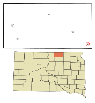
Isabel is a town in Dewey County, South Dakota, United States. The population was 145 at the 2020 census.

<span class="mw-page-title-main">Corsica, South Dakota</span> City in South Dakota, United States

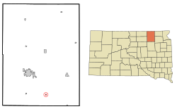
Corsica is a city in Douglas County, South Dakota, United States. The population was 561 at the 2020 census.

<span class="mw-page-title-main">Onaka, South Dakota</span> Town in South Dakota, United States

Onaka is a town in Faulk County, South Dakota, United States. The population was 13 at the 2020 census.

<span class="mw-page-title-main">Stockholm, South Dakota</span> Town in South Dakota, United States

Stockholm is a town in Grant County, South Dakota, United States. The population was 102 at the 2020 census.

<span class="mw-page-title-main">Ramona, South Dakota</span> Town in South Dakota, United States

Ramona is a town in Lake County, South Dakota, United States. The population was 159 at the 2020 census.

<span class="mw-page-title-main">Wetonka, South Dakota</span> Town in South Dakota, United States

Wetonka is a town in McPherson County, South Dakota, United States. The population was 16 at the 2020 census.

<span class="mw-page-title-main">Crooks, South Dakota</span> City in South Dakota, United States

Crooks is a city in Minnehaha County, South Dakota, United States and is a suburb of Sioux Falls. The population was 1,362 at the 2020 census. Crooks was named New Hope until 1904. The town's present name honors W. A. Crooks, a local politician.

<span class="mw-page-title-main">Humboldt, South Dakota</span> Town in South Dakota, United States

Humboldt is a town in Minnehaha County, South Dakota, United States. The population was 579 at the 2020 census.

<span class="mw-page-title-main">Ortley, South Dakota</span> Town in South Dakota, United States

Ortley is a town in Roberts County, South Dakota, United States. The population was 50 according to the 2020 census.

<span class="mw-page-title-main">Brentford, South Dakota</span> Town in South Dakota, United States

Brentford is a town in Spink County, South Dakota, United States. The population was 88 at the 2020 census.

<span class="mw-page-title-main">St. Francis, South Dakota</span> Town in South Dakota, United States

St. Francis also Sápauŋ thí is a town on the Rosebud Indian Reservation in Todd County, South Dakota, United States. The population was 469 at the 2020 census.

<span class="mw-page-title-main">Chancellor, South Dakota</span> Town in South Dakota, United States

Chancellor is a town in Turner County, South Dakota, United States. The population was 300 at the 2020 census.

<span class="mw-page-title-main">Davis, South Dakota</span> Town in South Dakota, United States

Davis is a town in Turner County, South Dakota, United States. The population was 54 at the 2020 census.

<span class="mw-page-title-main">Stratford, Wisconsin</span> Village in Wisconsin, United States

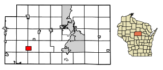
Stratford is a village in Marathon County, Wisconsin, United States. It is part of the Wausau, Wisconsin Metropolitan Statistical Area. The population was 1,578 at the 2010 census.

References

  1. "SD Towns" (PDF). South Dakota State Historical Society . Retrieved February 15, 2010.
  2. "ArcGIS REST Services Directory". United States Census Bureau. Retrieved October 15, 2022.
  3. 1 2 U.S. Geological Survey Geographic Names Information System: Stratford, South Dakota
  4. 1 2 "Census Population API". United States Census Bureau. Retrieved October 15, 2022.
  5. 1 2 "U.S. Census website". United States Census Bureau . Retrieved January 31, 2008.
  6. "U.S. Census Bureau: Stratford town, South Dakota". www.census.gov. United States Census Bureau. Retrieved February 12, 2022.
  7. Federal Writers' Project (1940). South Dakota place-names, v.1-3. University of South Dakota. p. 62.
  8. "US Gazetteer files 2010". United States Census Bureau. Archived from the original on January 12, 2012. Retrieved June 21, 2012.
  9. United States Census Bureau. "Census of Population and Housing" . Retrieved June 23, 2016.
  10. "Population Estimates". United States Census Bureau . Retrieved March 22, 2019.
  11. "U.S. Census website". United States Census Bureau . Retrieved June 21, 2012.