Smethwick is an industrial town in Sandwell, West Midlands, England. It lies 4 miles (6 km) west of Birmingham city centre. Historically it was in Staffordshire and then Worcestershire before being placed into then West Midlands county.
Edgbaston is a suburb of Birmingham, West Midlands, England. It lies immediately south-west of Birmingham city centre, and was historically in Warwickshire. The wards of Edgbaston and North Edgbaston had a combined population of 42,295 at the 2021 census.

Harborne is an area of south-west Birmingham, England. It is located three miles southwest from Birmingham city centre. It is a Birmingham City Council ward in the formal district and in the parliamentary constituency of Birmingham Edgbaston.

Selly Oak is an industrial and residential area in south-west Birmingham, England. The area gives its name to Selly Oak ward and includes the neighbourhoods of: Bournbrook, Selly Park, and Ten Acres. The adjoining wards of Edgbaston and Harborne are to the north of the Bourn Brook, which was the former county boundary, and to the south are Weoley, and Bournville. A district committee serves the four wards of Selly Oak, Billesley, Bournville and Brandwood. The same wards form the Birmingham Selly Oak constituency, represented since 2010 by Steve McCabe (Labour). Selly Oak is connected to Birmingham by the Pershore Road (A441) and the Bristol Road (A38). The Worcester and Birmingham Canal and the Birmingham Cross-City Railway Line run across the Local District Centre.

Quinton is a suburb and ward of Birmingham, England, 5 miles (8 km) west of the city centre. Formerly part of Halesowen parish, Quinton became part of Birmingham in 1909. Quinton was a village and the surrounding area was farmland until the 1930s when the first housing estates were developed. Most of the farmland had been built on by 1980 but some countryside remains in the form of Woodgate Valley Country Park. Along with Bartley Green, Harborne and Edgbaston, Quinton is within the Birmingham Edgbaston constituency.

Although Birmingham in England has existed as a settlement for over a thousand years, today's city is overwhelmingly a product of the 18th, 19th, and 20th centuries, with little surviving from its early history. As it has expanded, it has acquired a variety of architectural styles. Buildings of most modern architectural styles in the United Kingdom are located in Birmingham. In recent years, Birmingham was one of the first cities to exhibit the blobitecture style with the construction of the Selfridges store at the Bullring Shopping Centre.

Birmingham Edgbaston is a constituency, represented in the House of Commons of the UK Parliament since 2017 by Preet Gill, a Labour Co-op MP.

Edgbaston Reservoir, originally known as Rotton Park Reservoir and referred to in some early maps as Rock Pool Reservoir, is a canal feeder reservoir in Birmingham, England, maintained by the Canal & River Trust. It is situated close to Birmingham City Centre and is a Site of Importance for Nature Conservation.

Bournbrook is an industrial and residential district in southwest Birmingham, England, in the ward of Bournbrook and Selly Park and the parliamentary constituency of Birmingham Selly Oak. Before 2018 it was in Selly Oak Council Ward. Prior to what is commonly termed the Greater Birmingham Act, which came into effect on 9 November 1911, the Bourn Brook watercourse was the North Eastern boundary of Worcestershire, and the area was locally governed by the King's Norton and Northfield Urban District Council.

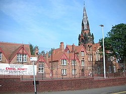
The Church of St Augustine of Hippo in Lyttelton Road, Edgbaston, Birmingham, England, is a parish church in the Church of England.
The Harborne Railway was a short standard gauge railway line constructed for residential travel from the Harborne area into the centre of Birmingham, England. The line opened in 1874, and was worked by the London and North Western Railway. As business developed, an increasingly frequent passenger service was operated, at its peak thirty trains each way daily.
Icknield Port Road railway station was a railway station in England, built by the Harborne Railway and operated by the London and North Western Railway in 1874.
This article is intended to show a timeline of events in the History of Birmingham, England, with a particular focus on the events, people or places that are covered in Wikipedia articles.

Rotton Park Road railway station was a railway station in England, built by the Harborne Railway and operated by the London and North Western Railway in 1874.
Hagley Road railway station was a railway station in Birmingham, England, built by the Harborne Railway and operated by the London and North Western Railway in 1874. In addition to the passenger facilities, there was also a goods yard and a coal wharf.

Edgbaston ward is a local government district, one of 40 wards that make up Birmingham City Council. Edgbaston lies to the south west of Birmingham city centre and is home to the University of Birmingham and the Queen Elizabeth hospital. The ward population at the 2011 census was 24,426.
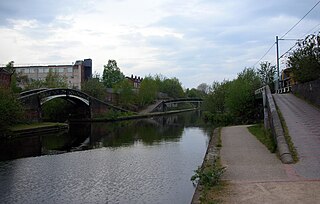
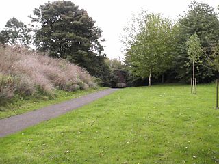
The Icknield Port Loop is a 0.6-mile (1 km) loop of the eighteenth-century-built Old BCN Main Line canal in Birmingham, England, about 2 miles (3 km) west of the city centre, which opened to traffic on 6 November 1769 and in some definitions includes its straighter bypass built in September 1827, a 550-yard (500 m) section of the New BCN Main Line. Most of the 56 acres (23 ha) of land thereby enclosed is derelict meaning the canal serves the Canal & River Trust maintenance depot at Icknield Port and conveys water from Edgbaston Reservoir to the BCN Main Line. The enclosed land has no pedestrian or vehicular access. Icknield Port (Loop) takes its name from the Roman Icknield Street which passed nearby, the exact route of which is unknown.
Rotton Park is an area of Birmingham, England, encompassing the north of Edgbaston Ward and the southern extremes of Soho Ward, to the city boundary with Smethwick.
George Harry Devall (1869–1956) was a British architect, who worked in Birmingham in the late nineteenth and early twentieth centuries, contributing much to the streetscape of the city. He was a contemporary of J. L. Ball, William Bidlake, Herbert Tudor Buckland, W. A. Harvey, and William Haywood, all of whom lived in Edgbaston and had architect practices in the city.