Summit, Arkansas

Last updated

Summit, Arkansas
Summit City Hall.jpg
Summit city hall
Marion County Arkansas Incorporated and Unincorporated areas Summit Highlighted 0567940.svg
Location in Marion County, Arkansas
Coordinates: 36°15′08″N92°41′18″W / 36.25222°N 92.68833°W / 36.25222; -92.68833
Country United States
State Arkansas
County Marion
Area
[1]
  Total1.21 sq mi (3.12 km2)
  Land1.21 sq mi (3.12 km2)
  Water0.00 sq mi (0.00 km2)
Elevation
[2]
863 ft (263 m)
Population
 (2020) [3]
  Total544
  Density451.08/sq mi (174.17/km2)
Time zone UTC-6 (Central (CST))
  Summer (DST) UTC-5 (CDT)
ZIP code
72677
Area code 870
FIPS code 05-67940
GNIS feature ID2405545 [2]

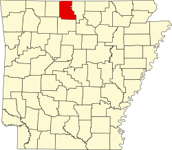
Summit is a city in Marion County, Arkansas, United States. The population was 544 at the 2020 census, [3] down from 604 in 2010.

Contents

Geography

Summit is located in central Marion County and is bordered to the south by the city of Yellville, the Marion county seat. Arkansas Highway 14 is Summit's Main Street; the highway leads south to the center of Yellville and northwest 22 miles (35 km) to Lead Hill. State Highway 202 (Park Avenue) leads southwest 1 mile (1.6 km) to U.S. Routes 412 and 62, and northeast 7 miles (11 km) to Flippin.

According to the United States Census Bureau, the city of Summit has a total area of 1.2 square miles (3.1 km2), all land. [1] The city is drained by Town Branch and its East Prong, which lead southeast to Crooked Creek, an east-flowing tributary of the White River.

Demographics

Historical population
CensusPop.Note
1930 122
1940 19862.3%
1950 26835.4%
1960 239−10.8%
1970 32134.3%
1980 50657.6%
1990 480−5.1%
2000 58622.1%
2010 6043.1%
2020 544−9.9%
U.S. Decennial Census [4]

As of the census [5] of 2000, there were 586 people, 234 households, and 156 families residing in the city. The population density was 478.2 inhabitants per square mile (184.6/km2). There were 280 housing units at an average density of 228.5 per square mile (88.2/km2). The racial makeup of the city was 96.42% White, 0.51% Black or African American, 1.54% Native American, 0.17% from other races, and 1.37% from two or more races. 1.54% of the population were Hispanic or Latino of any race.

There were 234 households, out of which 38.9% had children under the age of 18 living with them, 44.0% were married couples living together, 16.2% had a female householder with no husband present, and 33.3% were non-families. 30.3% of all households were made up of individuals, and 11.5% had someone living alone who was 65 years of age or older. The average household size was 2.50 and the average family size was 3.12.

In the city, the population was spread out, with 30.5% under the age of 18, 9.2% from 18 to 24, 29.0% from 25 to 44, 20.3% from 45 to 64, and 10.9% who were 65 years of age or older. The median age was 32 years. For every 100 females, there were 112.3 males. For every 100 females age 18 and over, there were 98.5 males.

The median income for a household in the city was $22,500, and the median income for a family was $27,308. Males had a median income of $20,054 versus $18,214 for females. The per capita income for the city was $10,393. About 13.5% of families and 20.2% of the population were below the poverty line, including 29.7% of those under age 18 and 8.1% of those age 65 or over.

Education

Public education for early childhood, elementary and secondary school students is provided by the Yellville–Summit School District, which leads to graduation from Yellville–Summit High School.

Related Research Articles

<span class="mw-page-title-main">Marion County, Arkansas</span> County in Arkansas, United States

Marion County is located in the Ozark Mountains in the U.S. state of Arkansas. The county is named for Francis Marion, the famous "Swamp Fox" of the Revolutionary War. Created as Arkansas's 35th county in 1836, Marion County is home to one incorporated town and four incorporated cities, including Yellville, the county seat. The county is also the site of numerous unincorporated communities and ghost towns. The county included part of what is now Searcy County, Arkansas, with many opposing to dividing them, which helped fueled the bloody Tutt-Everett War between 1844 and 1850.

<span class="mw-page-title-main">Salesville, Arkansas</span> City in Arkansas, United States

Salesville is a city in Baxter County, Arkansas, United States. The population was 450 in 2010.

<span class="mw-page-title-main">Decatur, Arkansas</span> City in Arkansas, United States

Decatur is a city, in Benton County, Arkansas, United States. The population was 1,773 at the 2020 census. It is part of the Northwest Arkansas region. This town is named after Commodore Stephen Decatur, Jr.

<span class="mw-page-title-main">Diamond City, Arkansas</span> City in Arkansas, United States

Diamond City is a city in northeast Boone County, Arkansas, United States. The population was 782 at the 2010 census. It is part of the Harrison Micropolitan Statistical Area.

<span class="mw-page-title-main">Berryville, Arkansas</span> City in Arkansas, United States

Berryville is a city in Carroll County, Arkansas, United States. The population was 5,682 at the 2020 census. making it the largest city in Carroll County. Along with Eureka Springs, it is one of the two county seats of Carroll County.

<span class="mw-page-title-main">Quitman, Arkansas</span> City in Arkansas, United States

Quitman is a city in Cleburne and Faulkner counties in the U.S. state of Arkansas. Its population was 762 at the 2010 census. The portion of the city in Faulkner County is part of the Central Arkansas region.

<span class="mw-page-title-main">Turrell, Arkansas</span> City in Arkansas, United States

Turrell is a city in Crittenden County, Arkansas, United States. Per the 2020 census, the population was 517.

<span class="mw-page-title-main">Wilmar, Arkansas</span> City in Arkansas, United States

Wilmar is a city in Drew County, Arkansas, United States. The population was 511 at the 2010 census, down from 571 in 2000.

Branch is a city in Franklin County, Arkansas, United States. It is part of the Fort Smith, Arkansas-Oklahoma Metropolitan Statistical Area. The population was 367 at the 2010 census.

<span class="mw-page-title-main">Mineral Springs, Arkansas</span> City in Arkansas, United States

Mineral Springs is a city in Howard County, Arkansas, United States. The population was 1,208 at the 2010 census.

<span class="mw-page-title-main">Melbourne, Arkansas</span> City in Arkansas, United States

Melbourne is a city and county seat of Izard County, Arkansas, United States. The population was 1,848 at the 2010 census. It is home to the main campus of Ozarka College.

<span class="mw-page-title-main">Black Rock, Arkansas</span> City in Arkansas, United States

Black Rock is a city in Lawrence County, Arkansas, United States, along the Black River. The population was 662 at the 2010 census.

<span class="mw-page-title-main">Scranton, Arkansas</span> City in Arkansas, United States

Scranton is a city in Logan County, Arkansas, United States. The population was 224 at the 2010 census. It was named after Scranton, Pennsylvania.

<span class="mw-page-title-main">Carlisle, Arkansas</span> City in Arkansas, United States

Carlisle is a city in Lonoke County, Arkansas, United States. It is the easternmost municipality within the Little Rock–North Little Rock–Conway Metropolitan Statistical Area. Carlisle was incorporated in 1878. As of the 2010 census it had a population of 2,214.

<span class="mw-page-title-main">Bull Shoals, Arkansas</span> City in Arkansas, United States

Bull Shoals is a city in Marion County, Arkansas, United States, founded in 1954. The population was 1,952 at the 2020 census. Primarily a retirement and vacation center, Bull Shoals is bordered in three directions by the clear, deep, man-made Bull Shoals Lake.

<span class="mw-page-title-main">Flippin, Arkansas</span> City in Arkansas, United States

Flippin is a city in Marion County, Arkansas, United States. The population was 1,345 at the 2020 census.

<span class="mw-page-title-main">Pyatt, Arkansas</span> Town in Arkansas, United States

Pyatt is a town in western Marion County, Arkansas, United States. The population was 181 at the 2020 census, down from 221 in 2010.

<span class="mw-page-title-main">Yellville, Arkansas</span> City in Arkansas, United States

Yellville is a city in and county seat of Marion County, Arkansas, United States. Yellville is located in the Ozark Mountains along the banks of Crooked Creek, and neighbors the small town of Summit to the north. The population was 1,178 at the 2020 census. The town's original name is preserved in the Shawnee Town Branch, a local creek. The town holds an annual Turkey Trot Festival.

<span class="mw-page-title-main">Jasper, Arkansas</span> City in Arkansas, United States

Jasper is a city in Newton County, Arkansas, United States. According to the 2020 census, its population is 547. The city is the county seat of Newton County.

<span class="mw-page-title-main">Creal Springs, Illinois</span> City in Illinois, United States

Creal Springs is a city in Williamson County, Illinois, United States. The population was 543 at the 2010 census.

References

  1. 1 2 "2021 U.S. Gazetteer Files: Arkansas". United States Census Bureau. Retrieved May 31, 2022.
  2. 1 2 U.S. Geological Survey Geographic Names Information System: Summit, Arkansas
  3. 1 2 "P1. Race – Summit city, Arkansas: 2020 DEC Redistricting Data (PL 94-171)". U.S. Census Bureau. Retrieved May 31, 2022.
  4. "Census of Population and Housing". Census.gov. Retrieved June 4, 2015.
  5. "U.S. Census website". United States Census Bureau . Retrieved January 31, 2008.