Flippin, Arkansas

Last updated

Flippin, Arkansas
Sign outside of city hall in downtown Flippin advertising local events. (19179762075).jpg
Sign in front of Flippin city hall
City of Flippin Logo.png
Marion County Arkansas Incorporated and Unincorporated areas Flippin Highlighted 0524010.svg
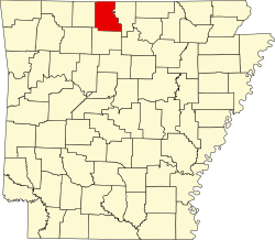
Location in Marion County, Arkansas
Coordinates: 36°16′38″N92°35′37″W / 36.27722°N 92.59361°W / 36.27722; -92.59361
Country United States
State Arkansas
County Marion
Area
[1]
  Total1.88 sq mi (4.88 km2)
  Land1.88 sq mi (4.88 km2)
  Water0.00 sq mi (0.00 km2)
Elevation
[2]
633 ft (193 m)
Population
 (2020) [3]
  Total1,345
  Density714.29/sq mi (275.78/km2)
Time zone UTC-6 (Central (CST))
  Summer (DST) UTC-5 (CDT)
ZIP code
72634
Area code 870
FIPS code 05-24010
GNIS feature ID2403618 [2]
Website www.flippincity.com

Flippin is a city in Marion County, Arkansas, United States. The population was 1,345 at the 2020 census. [3]

Contents

The city was named for the Thomas H. Flippin family and was incorporated in 1921. [4] The Thomas H. Flippin Chapter of the Arkansas State Society, National Society United States Daughters of 1812, was named for the military service of SGT Thomas H. Flippin of Captain Hugh Brown’s Company, 1st Regiment, Kentucky Mounted Militia during the War of 1812.

Geography

Flippin is located in eastern Marion County north of US 412/62, in the Ozarks south of Bull Shoals Lake. The town lies 3 miles (5 km) west of the White River. US 412/62 leads southwest 7 miles (11 km) to Yellville, the Marion county seat, and northeast 14 miles (23 km) to Mountain Home.

According to the United States Census Bureau, the city of Flippin has a total area of 1.9 square miles (4.9 km2), all land. [1]

Climate

The climate in this area is characterized by hot, humid summers and generally mild to cool winters. According to the Köppen Climate Classification system, Flippin has a humid subtropical climate, abbreviated "Cfa" on climate maps. [5]

Demographics

Historical population
CensusPop.Note
1930 325
1940 3322.2%
1950 64694.6%
1960 433−33.0%
1970 62644.6%
1980 1,07271.2%
1990 1,006−6.2%
2000 1,35734.9%
2010 1,355−0.1%
2020 1,345−0.7%
U.S. Decennial Census [6]

2020 census

Flippin racial composition [7]
RaceNumberPercentage
White (non-Hispanic)1,22491.0%
Black or African American (non-Hispanic)10.07%
Native American 151.12%
Asian 40.3%
Other/Mixed 604.46%
Hispanic or Latino 413.05%

As of the 2020 United States census, there were 1,345 people, 594 households, and 306 families residing in the city.

2000 census

As of the census [8] of 2000, there were 1,357 people, 583 households, and 357 families residing in the city. The population density was 755.7 inhabitants per square mile (291.8/km2). There were 644 housing units at an average density of 358.7 per square mile (138.5/km2). The racial makeup of the city was 95.87% White, 0.44% Black or African American, 1.11% Native American, 0.29% Asian, 0.07% from other races, and 2.21% from two or more races. 0.81% of the population were Hispanic or Latino of any race.

There were 583 households, out of which 29.2% had children under the age of 18 living with them, 44.3% were married couples living together, 14.2% had a female householder with no husband present, and 38.6% were non-families. 33.4% of all households were made up of individuals, and 16.1% had someone living alone who was 65 years of age or older. The average household size was 2.33 and the average family size was 2.99.

In the city, the population was spread out, with 27.9% under the age of 18, 8.7% from 18 to 24, 27.6% from 25 to 44, 20.0% from 45 to 64, and 15.8% who were 65 years of age or older. The median age was 35 years. For every 100 females, there were 85.4 males. For every 100 females age 18 and over, there were 74.5 males.

Economy

Located close to the White River, tourism plays a vital role in the Flippin economy with several resorts that feature trout fishing and lodging on the river. Ranger Boats was founded in and continues to operate out of Flippin.

Education

Public education for elementary and secondary school students is provided by the Flippin School District and its three schools including Flippin High School.

Infrastructure

Highways

See also

Related Research Articles

<span class="mw-page-title-main">Marion County, Arkansas</span> County in Arkansas, United States

Marion County is located in the Ozark Mountains in the U.S. state of Arkansas. The county is named for Francis Marion, the famous "Swamp Fox" of the Revolutionary War. Created as Arkansas's 35th county in 1836, Marion County is home to one incorporated town and four incorporated cities, including Yellville, the county seat. The county is also the site of numerous unincorporated communities and ghost towns. The county included part of what is now Searcy County, Arkansas, with many opposing to dividing them, which helped fueled the bloody Tutt-Everett War between 1844 and 1850.

<span class="mw-page-title-main">Lawrence County, Arkansas</span> County in Arkansas, United States

Lawrence County is a county located in the U.S. state of Arkansas. As of the 2020 census, the population was 16,216. The county seat is Walnut Ridge. Lawrence County is Arkansas's second county, formed on January 15, 1815, and named for Captain James Lawrence who fought in the War of 1812. It is an alcohol prohibition or dry county.

<span class="mw-page-title-main">Portland, Arkansas</span> Town in Arkansas, United States

Portland is a town in Ashley County, Arkansas, United States. The population was 430 at the 2010 census. Portland was first settled in the 1830s, and named for its early status as a steamboat port. It was incorporated in 1893.

<span class="mw-page-title-main">Diamond City, Arkansas</span> City in Arkansas, United States

Diamond City is a city in northeast Boone County, Arkansas, United States. The population was 782 at the 2010 census. It is part of the Harrison Micropolitan Statistical Area.

<span class="mw-page-title-main">Beaver, Arkansas</span> Town in Arkansas, United States

Beaver is a town in Carroll County, Arkansas, United States. As of the 2020 census it had a population of 67. The community is located on the White River at the western limits of Table Rock Lake deep in the Ozark Mountains. Located north of Eureka Springs, the small town has been featured in movies for its picturesque scenery. The town is known for the Beaver Bridge, a two-panel suspension bridge over the White River listed on the National Register of Historic Places.

<span class="mw-page-title-main">Salem, Fulton County, Arkansas</span> City in Arkansas, United States

Salem is the county seat of Fulton County, Arkansas, United States. Salem was first incorporated in 1900. As of the 2010 census the population stood at 1,635.

<span class="mw-page-title-main">Mountain Pine, Arkansas</span> City in Arkansas, United States

Mountain Pine is a city in Garland County, Arkansas, United States. It is part of the Hot Springs Metropolitan Statistical Area. The population was 770 at the 2010 United States Census. It is located immediately southeast of Lake Ouachita below the Blakely Mountain Dam. The city consists of five defined neighborhoods, Pinewood (north), South Mountain Pine, a business district, Cozy Acres (southwest) and Mountain View/Timberland area.

<span class="mw-page-title-main">Paragould, Arkansas</span> City in Arkansas, United States

Paragould is the county seat of Greene County, and the 19th-largest city in Arkansas, in the United States. The city is located in northeastern Arkansas on the eastern edge of Crowley's Ridge, a geologic anomaly contained within the Arkansas delta.

<span class="mw-page-title-main">Calico Rock, Arkansas</span> City in Arkansas, United States

Calico Rock is a city in Izard County, Arkansas, United States. The population was 1,545 at the 2010 census, up from 991 in 2000.

<span class="mw-page-title-main">Buckner, Arkansas</span> Town in Arkansas, United States

Buckner is a town in Lafayette County, Arkansas, United States. The population was 275 at the 2010 census.

<span class="mw-page-title-main">Lewisville, Arkansas</span> City in Arkansas, United States

Lewisville is a city in Lafayette County, Arkansas, United States. The population was 1,280 at the 2010 census. It is the county seat of Lafayette County.

<span class="mw-page-title-main">Walnut Ridge, Arkansas</span> City in Arkansas, United States

Walnut Ridge is a city in and the county seat of Lawrence County, Arkansas, United States. The population was 5,098 at the United States Census's 2019 estimate. Walnut Ridge lies immediately north of Hoxie. The two towns form a contiguous urban area with approximately 8,000 residents. Williams Baptist University is in College City, a formerly separate community that merged into Walnut Ridge in 2017.

<span class="mw-page-title-main">Bull Shoals, Arkansas</span> City in Arkansas, United States

Bull Shoals is a city in Marion County, Arkansas, United States, founded in 1954. The population was 1,952 at the 2020 census. Primarily a retirement and vacation center, Bull Shoals is bordered in three directions by the clear, deep, man-made Bull Shoals Lake.

<span class="mw-page-title-main">Pyatt, Arkansas</span> Town in Arkansas, United States

Pyatt is a town in western Marion County, Arkansas, United States. The population was 181 at the 2020 census, down from 221 in 2010.

<span class="mw-page-title-main">Summit, Arkansas</span> City in Arkansas, United States

Summit is a city in Marion County, Arkansas, United States. The population was 544 at the 2020 census, down from 604 in 2010.

<span class="mw-page-title-main">Yellville, Arkansas</span> City in Arkansas, United States

Yellville is a city in and county seat of Marion County, Arkansas, United States. Yellville is located in the Ozark Mountains along the banks of Crooked Creek, and neighbors the small town of Summit to the north. The population was 1,178 at the 2020 census. The town's original name is preserved in the Shawnee Town Branch, a local creek. The town holds an annual Turkey Trot Festival.

<span class="mw-page-title-main">Keiser, Arkansas</span> City in Arkansas, United States

Keiser is a city in Mississippi County, Arkansas, United States. The population was 751 at the 2020 census.

<span class="mw-page-title-main">Mount Ida, Arkansas</span> City in Arkansas, United States

Mount Ida is a city in and county seat of Montgomery County, Arkansas, United States. Founded in 1842, the city saw a silver boom in the 1880s bring early prosperity and economic development to the area. Today, the economy is largely ranching, poultry farming, silviculture, and tourism around Lake Ouachita. It is known as the quartz crystal capital of the U.S. and is known worldwide for its quartz deposits. The population was 996 as of the 2020 census.

<span class="mw-page-title-main">Greenland, Arkansas</span> City in Arkansas, United States

Greenland is a city in Washington County, Arkansas, United States. The population is 1,213 as of the 2020 census. The community is located in the Boston Mountains, within the Ozark Mountains.

<span class="mw-page-title-main">Hartford, Maine</span> Town in the state of Maine, United States

Hartford is a town in Oxford County, Maine, United States. Hartford is included in the Lewiston-Auburn, Maine metropolitan New England City and Town Area. The population was 1,203 at the 2020 census.

References

  1. 1 2 "2021 U.S. Gazetteer Files: Arkansas". United States Census Bureau. Retrieved May 31, 2022.
  2. 1 2 U.S. Geological Survey Geographic Names Information System: Flippin, Arkansas
  3. 1 2 "P1. Race – Flippin city, Arkansas: 2020 DEC Redistricting Data (PL 94-171)". U.S. Census Bureau. Retrieved May 31, 2022.
  4. "Flippin, Arkansas".
  5. Climate Summary for Flippin, Arkansas
  6. "Census of Population and Housing". Census.gov. Retrieved June 4, 2015.
  7. "Explore Census Data". data.census.gov. Retrieved January 1, 2022.
  8. "U.S. Census website". United States Census Bureau . Retrieved January 31, 2008.