Syracuse, Ohio

Last updated

Syracuse, Ohio
Syracuse Elementary School, 45779.jpg
Community center and former school
OHMap-doton-Syracuse.png
Location of Syracuse, Ohio
Map of Meigs County Ohio Highlighting Syracuse Village.png
Location of Syracuse in Meigs County
Coordinates: 38°00′02″N81°58′24″W / 38.00056°N 81.97333°W / 38.00056; -81.97333
Country United States
State Ohio
County Meigs
Township Sutton
Area
[1]
  Total0.90 sq mi (2.34 km2)
  Land0.88 sq mi (2.28 km2)
  Water0.02 sq mi (0.06 km2)
Elevation
[2]
640 ft (200 m)
Population
 (2020)
  Total781
  Density887.50/sq mi (342.66/km2)
Time zone UTC-5 (Eastern (EST))
  Summer (DST) UTC-4 (EDT)
ZIP code
45779
Area code 740
FIPS code 39-76050 [3]
GNIS feature ID2399945 [2]

Syracuse is a village in Meigs County, Ohio, United States, along the Ohio River. The population was 781 at the 2020 census.

Contents

Geography

According to the United States Census Bureau, the village has a total area of 0.96 square miles (2.49 km2), of which 0.93 square miles (2.41 km2) is land and 0.03 square miles (0.08 km2) is water. [4]

Demographics

Historical population
CensusPop.Note
1860 720
1870 1,27376.8%
1880 1,54521.4%
1930 678
1940 676−0.3%
1950 7003.6%
1960 7314.4%
1970 684−6.4%
1980 94638.3%
1990 827−12.6%
2000 8796.3%
2010 826−6.0%
2020 781−5.4%
U.S. Decennial Census [5]

2010 census

As of the census [6] of 2010, there were 826 people, 360 households, and 248 families living in the village. The population density was 888.2 inhabitants per square mile (342.9/km2). There were 418 housing units at an average density of 449.5 per square mile (173.6/km2). The racial makeup of the village was 97.2% White, 0.8% African American, 0.4% Native American, 0.1% Asian, and 1.5% from two or more races. Hispanic or Latino of any race were 0.1% of the population.

There were 360 households, of which 29.4% had children under the age of 18 living with them, 49.2% were married couples living together, 13.9% had a female householder with no husband present, 5.8% had a male householder with no wife present, and 31.1% were non-families. 28.3% of all households were made up of individuals, and 14.7% had someone living alone who was 65 years of age or older. The average household size was 2.29 and the average family size was 2.75.

The median age in the village was 45.8 years. 20.3% of residents were under the age of 18; 7.1% were between the ages of 18 and 24; 21.4% were from 25 to 44; 29.3% were from 45 to 64; and 21.8% were 65 years of age or older. The gender makeup of the village was 47.6% male and 52.4% female.

2000 census

As of the census [3] of 2000, there were 879 people, 382 households, and 258 families living in the village. The population density was 952.8 inhabitants per square mile (367.9/km2). There were 423 housing units at an average density of 458.5 per square mile (177.0/km2). The racial makeup of the village was 97.84% White, 0.91% African American, 0.23% Native American, and 1.02% from two or more races. Hispanic or Latino of any race were 0.11% of the population.

There were 382 households, out of which 23.6% had children under the age of 18 living with them, 56.0% were married couples living together, 9.2% had a female householder with no husband present, and 32.2% were non-families. 28.8% of all households were made up of individuals, and 17.8% had someone living alone who was 65 years of age or older. The average household size was 2.30 and the average family size was 2.82.

In the village, the population was spread out, with 19.8% under the age of 18, 7.6% from 18 to 24, 24.6% from 25 to 44, 27.9% from 45 to 64, and 20.1% who were 65 years of age or older. The median age was 44 years. For every 100 females, there were 92.8 males. For every 100 females age 18 and over, there were 88.0 males.

The median income for a household in the village was $29,423, and the median income for a family was $37,813. Males had a median income of $41,389 versus $18,750 for females. The per capita income for the village was $19,279. About 11.8% of families and 15.5% of the population were below the poverty line, including 28.4% of those under age 18 and 8.0% of those age 65 or over.

Education

Public education in the village of Syracuse is provided by the Southern Local School District. Campuses serving the village include Southern Elementary School (Grades K-8) and Southern High School (Grades 9-12).

Notable person

See also

Related Research Articles

<span class="mw-page-title-main">Gordon, Ohio</span> Village in Ohio, United States

Gordon is a village in Darke County, Ohio, United States. The population was 245 at the 2020 census.

<span class="mw-page-title-main">Ithaca, Ohio</span> Village in Ohio, United States

Ithaca is a village in Darke County, Ohio, United States. The population was 81 at the 2020 census.

<span class="mw-page-title-main">Palestine, Ohio</span> Village in Ohio, United States

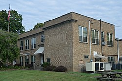
Palestine is a village in Darke County, Ohio, United States. The population was 180 at the 2020 census.

<span class="mw-page-title-main">Yorkshire, Ohio</span> Village in Ohio, United States

Yorkshire is a village in Darke County, Ohio, United States. The population was 95 at the 2020 census.

<span class="mw-page-title-main">Addyston, Ohio</span> Village in Ohio, United States

Addyston is a village in Miami Township, Hamilton County, Ohio, United States. Located along the Ohio River, it is a western suburb of the neighboring city of Cincinnati. The population was 927 at the 2020 census.

<span class="mw-page-title-main">Cleves, Ohio</span> City in Ohio, United States

Cleves is a village in Miami Township, Hamilton County, Ohio, United States. Located along the Ohio River, it is a western suburb of Cincinnati. The population was 3,414 at the 2020 census.

<span class="mw-page-title-main">Evendale, Ohio</span> Village in Ohio, United States

Evendale is a village in Hamilton County, Ohio, United States, within the Cincinnati metropolitan area. The population was 2,669 at the 2020 census.

<span class="mw-page-title-main">Gann, Ohio</span> Village in Ohio, United States

Brinkhaven, once known as Mount Holly and Gann, is a village in Knox County, Ohio, United States. The population was 114 at the 2020 census.

<span class="mw-page-title-main">Hanover, Ohio</span> Village in Ohio, United States

Hanover is a village in Licking County, Ohio, United States. The population was 1,270 at the 2020 census. The village lies along Ohio State Route 16.

<span class="mw-page-title-main">Hebron, Ohio</span> Village in Ohio, USA

Hebron is a village in Licking County, Ohio, United States. The population was 2,326 at the 2020 census.

<span class="mw-page-title-main">Miltonsburg, Ohio</span> Village in Ohio, United States

Miltonsburg is a village in Monroe County, Ohio, United States. The population was 42 at the 2020 census. Miltonsburg was named after Milton Pierson, son of Ohio pioneer David Pierson. David Pierson named Clarington, Ohio after his daughter Clarinda.

<span class="mw-page-title-main">Shawnee, Perry County, Ohio</span> Village in Ohio, United States

Shawnee is a village in Perry County, Ohio, United States. The population was 505 at the 2020 census. It is 9 miles (14 km) south of the county seat of New Lexington.

<span class="mw-page-title-main">Darbyville, Ohio</span> Village in Ohio, United States

Darbyville is a village in Pickaway County, Ohio, United States. The population was 186 at the 2020 census.

<span class="mw-page-title-main">Tarlton, Ohio</span> Village in Ohio, United States

Tarlton is a village in Fairfield and Pickaway counties in the U.S. state of Ohio. The population was 254 at the 2020 census.

<span class="mw-page-title-main">Port Jefferson, Ohio</span> Village in Ohio, United States

Port Jefferson is a village in Salem Township, Shelby County, Ohio, United States. The population was 308 at the 2020 census.

<span class="mw-page-title-main">Elgin, Ohio</span> Village in Ohio, United States

Elgin is a village in Van Wert County, Ohio, United States. The population was 49 at the 2020 census. It is included within the Van Wert, Ohio Micropolitan Statistical Area.

<span class="mw-page-title-main">Macksburg, Ohio</span> Village in Ohio, United States

Macksburg is a village in Washington County, Ohio, United States, along the West Fork of Duck Creek. The population was 120 at the 2020 census. The village is about 28 miles (45 km) south of Cambridge, Ohio.
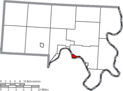
<span class="mw-page-title-main">Wilson, Ohio</span> Village in Ohio, United States

Wilson is a village in Belmont and Monroe counties in the U.S. state of Ohio. The population was 129 at the 2020 census. It is part of the Wheeling metropolitan area.

<span class="mw-page-title-main">Gratiot, Ohio</span> Village in Ohio, United States

Gratiot is a village in Licking and Muskingum counties in the U.S. state of Ohio. The population was 215 at the 2020 census.

<span class="mw-page-title-main">Verona, Ohio</span> Village in Ohio, United States

Verona is a village in Montgomery and Preble counties in the U.S. state of Ohio. The population was 403 at the 2020 census. It is part of the Dayton Metropolitan Statistical Area.

References

  1. "ArcGIS REST Services Directory". United States Census Bureau. Retrieved September 20, 2022.
  2. 1 2 U.S. Geological Survey Geographic Names Information System: Syracuse, Ohio
  3. 1 2 "U.S. Census website". United States Census Bureau . Retrieved January 31, 2008.
  4. "US Gazetteer files 2010". United States Census Bureau. Archived from the original on January 25, 2012. Retrieved January 6, 2013.
  5. "Census of Population and Housing". Census.gov. Retrieved June 4, 2015.
  6. "U.S. Census website". United States Census Bureau . Retrieved January 6, 2013.