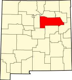
Tecolote, New Mexico | |
---|---|
Coordinates: 35°27′38″N105°17′03″W / 35.46056°N 105.28417°W | |
Country | United States |
State | New Mexico |
County | San Miguel |
Area | |
• Total | 5.63 sq mi (14.57 km2) |
• Land | 5.63 sq mi (14.57 km2) |
• Water | 0.00 sq mi (0.00 km2) |
Elevation | 6,316 ft (1,925 m) |
Population | |
• Total | 234 |
• Density | 41.60/sq mi (16.06/km2) |
Time zone | UTC-7 (Mountain (MST)) |
• Summer (DST) | UTC-6 (MDT) |
Area code | 505 |
GNIS feature ID | 2584222 [2] |
Tecolote is an unincorporated community and census-designated place in San Miguel County, New Mexico, United States. Its population was 298 as of the 2010 census. [4] The community is located along Interstate 25 at Exit 335.
According to the U.S. Census Bureau, the community has an area of 5.625 square miles (14.57 km2), all land. [4]
Census | Pop. | Note | %± |
---|---|---|---|
2020 | 234 | — | |
U.S. Decennial Census [5] [3] |
It is in the West Las Vegas Schools school district. [6] West Las Vegas High School is the area high school.
San Miguel County is a county in the U.S. state of New Mexico. As of the 2020 census, the population was 27,201. Its county seat is Las Vegas.
Rio Arriba County is a county in the U.S. state of New Mexico. As of the 2020 census, the population was 40,363. Its county seat is Tierra Amarilla. Its northern border is the Colorado state line.
Las Vegas, often known simply as Vegas, is a city in and the county seat of San Miguel County, New Mexico, United States. Once two separate municipalities, both were named Las Vegas—West Las Vegas and East Las Vegas ; they are separated by the Gallinas River and retain distinct characters and separate, rival school districts.
Pecos is a village in San Miguel County, New Mexico, United States. The population was 1,392 at the 2010 census, shrinking slower than other parts of San Miguel County, partly because Pecos is within commuting distance of Santa Fe. The village is built along the Pecos River, which flows from the north out of the Santa Fe National Forest. Notable locations nearby include Pecos National Historical Park, Glorieta Pass, and Pecos Benedictine Monastery. It is also an entry point for hunting, fishing, hiking and camping in the Pecos Wilderness. The closest metropolitan area is the Santa Fe metropolitan area, approximately 26 miles (42 km) to the west.
Villanueva is an unincorporated community and census-designated place in San Miguel County, New Mexico, United States. Known as La Cuesta until 1890, it is located along the Pecos River and New Mexico State Road 3. Villanueva has the ZIP code 87583. The 87583 ZIP Code Tabulation Area had a population of 234 in the 2010 United States census, compared to 267 in 2000. A total of 211 residents of Villanueva in 2010 identified themselves as Hispanic.
Ribera is an unincorporated community and census-designated place in San Miguel County, New Mexico. Located in the northern part of the state, it is at the foot of Rowe Mesa and along the Pecos River, 50 miles (80 km) southeast of Santa Fe.
Las Vegas City Schools is a school district based in Las Vegas, New Mexico, United States.
West Las Vegas Public Schools is a school district based in Las Vegas, New Mexico, United States.
Rowe is a census-designated place (CDP) in San Miguel County, New Mexico, United States.
Robertson High School (RHS) is a public senior high school in Las Vegas, New Mexico, United States. The school is part of the Las Vegas City Schools District in former East Las Vegas. The building dates from about 1945, when it was known as Las Vegas High School. The school was renamed Las Vegas Robertson High School in 1958, after the old Las Vegas High School burned down and a new building was constructed. W. J. Robertson had been the superintendent of the Las Vegas City Schools since 1941 when he suffered a fatal heart attack on November 26, 1956, at the age of 55. Mr. Robertson, born in Kansas on November 3, 1901, also served as principal at Las Vegas High School for many years prior. The colors of RHS are red and white, their mascot is the Cardinal. The enrollment currently stands at 414.
West Las Vegas High School (WLVHS) is a public senior high school in Las Vegas, New Mexico and part of the West Las Vegas Schools District. Founded in 1947, it is the oldest high school in the city.
Hispanic and Latino Nevadans are residents of the state of Nevada who are of Hispanic or Latino ancestry. As of the 2020 U.S. Census, Hispanics and Latinos of any race were 28.3% of the state's population.
San Jose is a census-designated place in San Miguel County, New Mexico, United States. Its population was 137 as of the 2010 census. San Jose has a post office, with ZIP code 87565. Exit 319 of Interstate 25 serves the community.
San Miguel is a census-designated place in Doña Ana County, New Mexico, United States. Its population was 1,153 as of the 2010 census. San Miguel has a post office with ZIP code 88058. The community is located at the junction of state routes 28 and 192.
Sena is an unincorporated community and census-designated place in San Miguel County, New Mexico, United States. It is located along the Pecos River and New Mexico State Highway 3.
East Pecos is an unincorporated community and census-designated place in San Miguel County, New Mexico, United States. Its population was 757 as of the 2010 census.
North San Ysidro is an unincorporated community and census-designated place in San Miguel County, New Mexico, United States. Its population was 159 as of the 2010 census.
Pueblo is an unincorporated community and census-designated place in San Miguel County, New Mexico, United States. Its population was 125 as of the 2010 census. New Mexico State Road 3 passes through the community.
Soham is an unincorporated community and census-designated place in San Miguel County, New Mexico, United States. Its population was 210 as of the 2010 census. The community is located near Exit 319 on Interstate 25.
Tecolotito is an unincorporated community and census-designated place in San Miguel County, New Mexico, United States. The word "Tecolotito" has its origin in the Nahuatl language. Adopted into Spanish it means "small owl." The population of the community was 232 as of the 2010 census, of which 213 people were of Hispanic origin.