
The Cascade Range or Cascades is a major mountain range of western North America, extending from southern British Columbia through Washington and Oregon to Northern California. It includes both non-volcanic mountains, such as many of those in the North Cascades, and the notable volcanoes known as the High Cascades. The small part of the range in British Columbia is referred to as the Canadian Cascades or, locally, as the Cascade Mountains. The highest peak in the range is Mount Rainier in Washington at 14,411 feet (4,392 m).

The Kettle Valley Railway was a subsidiary of the Canadian Pacific Railway (CPR) that operated across southern British Columbia, west of Midway running to Rock Creek, then north to Myra Canyon, down to Penticton over to Princeton, Coalmont, Brookmere, Coquihalla and finally Hope where it connected to the main CPR line.

The North Cascades are a section of the Cascade Range of western North America. They span the border between the Canadian province of British Columbia and the U.S. state of Washington and are officially named in the U.S. and Canada as the Cascade Mountains. The portion in Canada is known to Americans as the Canadian Cascades, a designation that also includes the mountains above the east bank of the Fraser Canyon as far north as the town of Lytton, at the confluence of the Thompson and Fraser Rivers.
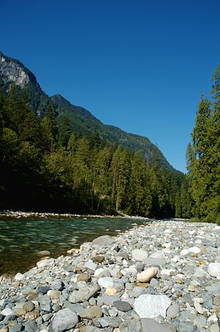
The Coquihalla River is a tributary of the Fraser River in the Cascade Mountains of the Canadian province of British Columbia. It originates in the Coquihalla Lakes and empties into the Fraser River at Hope.

Monarch Mountain is one of the principal summits of the Pacific Ranges subdivision of the Coast Mountains in southern British Columbia. It stands just east of a pass between the Klinaklini River and the south branch of the Atnarko River, which is a tributary of the Bella Coola River. Surrounding Monarch Mountain is the Monarch Icefield, the northernmost of the major icefields of the Pacific Ranges, and just south of it is the Ha-Iltzuk Icefield, which is the largest. Monarch is in the southern end of Tweedsmuir South Provincial Park.

Coquihalla Summit is a highway summit along the Coquihalla Highway in British Columbia, Canada. It is the highest point on the highway between the cities of Hope and Merritt. It is located just south of the former toll booth plaza on the Coquihalla Highway, about 50 km (31 mi) north of Hope, and 65 km (40 mi) south of Merritt and is the divide between the Coquihalla River and the Coldwater River.

The British Columbia Interior, popularly referred to as the BC Interior or simply the Interior, is a geographic region of the Canadian province of British Columbia. While the exact boundaries are variously defined, the British Columbia Interior is generally defined to include the 14 regional districts that do not have coastline along the Pacific Ocean or Salish Sea, and are not part of the Lower Mainland. Other boundaries may exclude parts of or even entire regional districts, or expand the definition to include the regional districts of Fraser Valley, Squamish–Lillooet, and Kitimat–Stikine.

Yak Peak is a granite summit located adjacent the Coquihalla Highway in British Columbia north of Hope. The mountain lies less than one km from a highway rest area, and is easily visible from a long stretch of the highway just south of the summit. It is known for some fine granite rock climbing routes, notably Yak Crack. Other mountains in the same group, usually known as the Anderson River Group or as the Coquihalla Range, are named after other similar animals, such as Thar Peak and Guanaco Peak.

The Hozameen Range is a mountain range in southwestern British Columbia and northern Washington, straddling the division between the Coast and Interior regions of that province. It is a subrange of the North Cascades and is neighboured on the east by the Okanagan Range and on the northwest by the unofficially-named Coquihalla Range, which lies between that river and the Fraser. In the northwest part of the range is the one named subrange, the Bedded Range.

The Skagit Range is a subrange of the Cascade Range in southwestern British Columbia, Canada and northwestern Washington, United States, which are known in Canada as the Canadian Cascades or, officially, the Cascade Mountains. It is also known in the Nooksack language as Nexwx̠ex̠tsán. The Skagit Range lies to the west of the Skagit River and east and north of the Chilliwack River and flanks the Upper Fraser Valley region of British Columbia's Lower Mainland.
Hope Mountain, commonly called Mount Hope, is a prominent mountain overlooking the town of Hope, British Columbia, Canada from the south. It is the northernmost summit of the Skagit Range of the Cascade Mountains and stands above the confluence of the Coquihalla and Fraser Rivers. Hope Mountain dominates the view of southbound travellers in the lower Fraser Canyon between Yale and Hope.

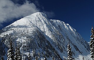
Coquihalla Mountain is an extinct stratovolcano in Similkameen Country, southwestern British Columbia, Canada, located 10 km (6.2 mi) south of Falls Lake and 22 km (14 mi) west of Tulameen between the Coquihalla and Tulameen rivers. With a topographic prominence of 816 m (2,677 ft), it towers above adjacent mountain ridges. It is the highest mountain in the Bedded Range of the northern Canadian Cascades with an elevation of 2,157 m (7,077 ft) and lies near the physiographic boundaries with the Coast Mountains on the west and the Interior Plateau on the east.

The Bedded Range is a mountain range in the Hozameen Range subdivision of the Canadian Cascades, which are the extension of the Cascade Range into British Columbia, Canada. Located between the Coquihalla and Tulameen Rivers, the Bedded Range is a dioritic plug related to the Chilliwack batholith.

The Britannia Range is a small mountain range of the Coast Mountains that runs along the eastern shore of Howe Sound just north of Vancouver, British Columbia, Canada. It is a subrange of the Pacific Ranges and often considered part of the North Shore Mountains. The range is bounded by the Howe Sound to the west, the Stawamus River to the north, Loch Lomond on the upper Seymour River to the east, and Deeks Lake to the south. However, some official maps extend the range further south of these boundaries and many local sources such as hiking guidebooks will often include all of the peaks along the Howe Sound between Deeks Lake and Cypress Mountain as part of the range.

The geography of the North Cascades describes a range of rugged mountains in British Columbia, Canada and Washington, United States. In Canada, the range is officially named the Cascade Mountains but is commonly referred to as the Canadian Cascades.
The Coquihalla Range is an informally named mountain range in British Columbia that lies between the Coquihalla River and the Fraser Canyon. It is part of the Canadian Cascades, which are officially named the Cascade Mountains and are the northernmost part of the Cascade Range, which begins in northern California. Other subranges of the Canadian Cascades are the Skagit Range, Hozameen Range and Okanagan Range

The Sundance Range is a mountain range in the Canadian Rockies, south of the town of Banff. It is located on the Continental Divide, which forms the boundary between British Columbia and Alberta in this region.
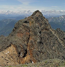
Thar Peak is a 1,940-metre (6,360-foot) mountain summit located in the Coquihalla Summit Recreation Area, in the North Cascades of southwestern British Columbia, Canada. It is situated at the east end of Zopkios Ridge, immediately west of the Falls Lake exit at Coquihalla Summit, and 1.55 km (1 mi) east of Yak Peak. Due to its close proximity to the Coquihalla Highway, the mountain attracts skiers to its slopes in winter. Precipitation runoff from the peak drains into tributaries of the Coquihalla River. The mountain was named for the thar, a Himalayan animal, and part of the ungulate names theme for several other nearby peaks that were submitted by Philip Kubik of Vancouver. The mountain's name was officially adopted on February 5, 1976, by the Geographical Names Board of Canada.

Needle Peak is a prominent 2,095-metre (6,873-foot) mountain summit located in the Coquihalla Summit Recreation Area, in the North Cascades of southwestern British Columbia, Canada. It is situated immediately southwest of Coquihalla Summit, and 4.2 km (3 mi) south-southwest of Yak Peak. Due to its close proximity to the Coquihalla Highway, the mountain is a popular hiking destination in summer, and skiing and snowshoeing in winter. Precipitation runoff from the peak drains into tributaries of the Coquihalla River. The mountain's descriptive name was officially adopted on October 6, 1936, by the Geographical Names Board of Canada.

Zupjok Peak is a 1,835-metre (6,020-foot) mountain summit located along the northwestern boundary of the Coquihalla Summit Recreation Area, in the North Cascades of southwestern British Columbia, Canada. It is situated north of the Coquihalla Highway, west of Zopkios Ridge, 6 km (4 mi) west of Coquihalla Summit, and 4 km (2 mi) south of Alpaca Peak. Precipitation runoff from the peak drains into headwaters of the Coldwater River, as well as tributaries of the Coquihalla River and Anderson River. The mountain was named for the zupjok,, the male progeny of a cattle bull and a female yak, and part of the ungulate names theme for several other nearby peaks that were submitted by Philip Kubik of Vancouver. The mountain's name was officially adopted on February 5, 1976, by the Geographical Names Board of Canada.

