Related Research Articles

The Peace River is a 1,923-kilometre-long (1,195 mi) river in Canada that originates in the Rocky Mountains of northern British Columbia and flows to the northeast through northern Alberta. The Peace River joins the Athabasca River in the Peace-Athabasca Delta to form the Slave River, a tributary of the Mackenzie River. The Finlay River, the main headwater of the Peace River, is regarded as the ultimate source of the Mackenzie River. The combined Finlay–Peace–Slave–Mackenzie river system is the 13th longest river system in the world.

Williston Lake is a reservoir created by the W. A. C. Bennett Dam and is located in the Northern Interior of British Columbia, Canada.
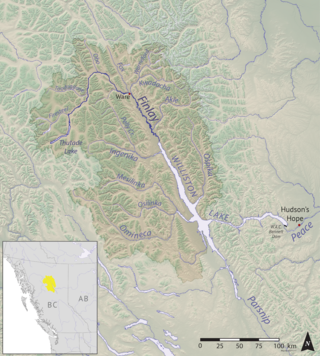
The Finlay River is a 402 km long river in north-central British Columbia flowing north and thence south from Thutade Lake in the Omineca Mountains to Williston Lake, the impounded waters of the Peace River formed by the completion of the W.A.C. Bennett Dam in 1968. Prior to this, the Finlay joined with the Parsnip River to form the Peace. The headwaters of the Finlay at Thutade Lake are considered the ultimate source of the Mackenzie River. Deserters Canyon is located just north of Williston Lake.
The Parsnip River is a 240-kilometre (150 mi) long river in central British Columbia, Canada. It flows generally north-westward from the Parsnip Glacier in the Hart Ranges to the Parsnip Reach of Williston Lake, formed by the impounding of the waters of the Peace River by the W.A.C. Bennett Dam in 1968. Prior to that, the Parsnip joined with the Finlay River to form the Peace at Finlay Forks, with both sharing an alignment along the Rocky Mountain Trench.
The Omineca Mountains, also known as "the Ominecas", are a group of remote mountain ranges in the Boreal Cordillera of north-central British Columbia, Canada. They are bounded by the Finlay River on the north, the Rocky Mountain Trench on the east, the Nation Lakes on the south, and the upper reaches of the Omineca River on the west. They form a section of the Continental Divide, that, in this region, separates water drainage between the Arctic and Pacific Oceans. The lower course of the Omineca River flows through the heart of the range. To the south of the Ominecas is the Nechako Plateau, to the west the Skeena Mountains and Hazelton Mountains, to the north the Spatsizi Plateau and the Stikine Ranges, while east across the Rocky Mountain Trench are the Muskwa Ranges.
The Stikine Ranges are a group of mountain ranges and mountainous plateaus in northwestern British Columbia, Canada. They are the northernmost subdivision of the Cassiar Mountains and among the least explored and most undeveloped parts of the province.
Ḵwiḵwa̱sut'inux̱w Ha̱xwa'mis, formerly the Kwicksutaineuk-ah-kwa-mish First Nation is a First Nations band government based on northern Vancouver Island in British Columbia, Canada, in the Queen Charlotte Strait region. It is a member of the Musgamagw Tsawataineuk Tribal Council, along with the ‘Namgis First Nation and the Tsawataineuk First Nation. The Kwikwasut'inuxw and Haxwa'mis are two of the many subgroups of the peoples known as Kwakwaka'wakw, which has two meanings: "smoke of the world" or "beach at the north side of the river."
The Lytton First Nation, a First Nations band government, has its headquarters at Lytton in the Fraser Canyon region of the Canadian province of British Columbia. While it is the largest of all Nlaka'pamux bands, unlike all other governments of the Nlaka'pamux (Thompson) people, it is not a member of any of the three Nlaka'pamux tribal councils, which are the Nicola Tribal Association, the Fraser Canyon Indian Administration and the Nlaka'pamux Nation Tribal Council.
The Samuel Black Range is a mountain range in the angle of the upper Toodoggone and the Finlay Rivers in northern British Columbia, Canada. It has an area of 808 km2 and is a subrange of the Omineca Mountains which in turn form part of the Interior Mountains. The range is named for Samuel Black, the first European to explore the area.
The Peak Range is a small subrange of the Swannell Ranges of the Omineca Mountains, located on the northwest side of the junction of Toodoggone River and Finlay River in northern British Columbia, Canada.
The Firesteel River is the uppermost left tributary of the Finlay River in the Northern Interior of British Columbia, Canada. The river originates at Tatlatui Lake, while the Finlay originates at the outlet of Thutade Lake, to the southeast, which is considered the ultimate source of the Mackenzie River.
Cascadero Falls is a waterfall on the Finlay River in the Northern Interior of British Columbia, Canada, located just below that river's head at the outlet of Thutade Lake. The height of the falls is 180 ft and below it there are numerous cascades or rapids in a twisting course prior to the river's general northeastward trend from this area. The falls are slated for hydroelectric development in connection with the area's mines, the largest of which is the Kemess Mine owned by Northgate Minerals Inc., located just east of the foot of Thutade Lake in the valley of Kemess Creek.
Metsantan Pass, 1,270 metres (4,167 ft), is a mountain pass in the Metsantan Range of the Omineca Mountains in the Northern Interior of British Columbia, Canada. It is located between Metsantan Lake, in the drainage basin of the Stikine River (NW) and the headwaters of the Toodoggone River (SE), a tributary of the Finlay River which is part of the Peace-Mackenzie River drainage area, and therefore is located along the Continental Divide.
The Tlowitsis Nation, formerly the Klowitsis Tribe, the Turnour Island Band and the Tlowitsis-Mumtagila First Nation, is the Indian Act band government of the Ławit'sis (Tlowitsis) tribe of the Kwakwaka'wakw peoples, located in the Queen Charlotte Strait-Johnstone Strait area in the Discovery Islands between Vancouver Island and the British Columbia mainland in Canada. Ławit'sis territory covers parts of northern Vancouver Island, Johnstone Strait, and adjoining inlets of the mainland. Kalugwis, on Turnour Island, was their principal community in times past, but the band's offices are in the city of Campbell River to the southeast. Hanatsa IR No. 6 on Port Neville is the most populated of the band's Indian reserves.
The Trout River is a tributary of the Liard River in far northern British Columbia, Canada, flowing northwest from headwaters at 58°44′N126°14′W, near Muncho Lake, to meet the Liard at the community of Liard River. It is at the upper end of the Grand Canyon of the Liard, which is part of Liard River Corridor Provincial Park and Protected Area.
The Smith River is a river in the Yukon Territory and the province of British Columbia, Canada, arising in the Yukon at 60°09′N126°18′W and crossing the border to enter British Columbia at 60°00′00″N126°23′25″W to its confluence with the Liard River at 59°33′00″N126°29′00″W, between the confluences of the Toad and Coal Rivers. At the confluence is the site of the former Hudson's Bay Company trading post, Fort Halkett, and also Smith River Falls, which are jointly protected by Smith River Falls-Fort Halkett Provincial Park.
Rose Lake is an unincorporated community on the Yellowhead Highway in the Bulkley Valley region of northwestern British Columbia, Canada. Its name is derived from the nearby waterbody Rose Lake. The community and the lake are along the northern mainline of the Canadian National Railway just northeast of Bulkley Lake.
Matilpi is a locality on the Central Coast of British Columbia, Canada, located northeast of Hull Island on the east side of Havannah Channel.
West Cracroft Island is an island in the Johnstone Strait region of the Central Coast of British Columbia, Canada, located east of Port McNeill. It is the larger of the two Cracroft Islands, the other, East Cracroft Island, being so named to distinguish between the two islands, which at low tide are one island.

Port Harvey is a port on the south side of the Cracroft Islands in the Johnstone Strait region of the Central Coast region of British Columbia, Canada, forming a small bay or inlet south of the shallows that link West Cracroft and East Cracroft Islands. On its east shore is Keecekiltum Indian Reserve No. 2, 11.7 ha., which is under the governance of the Tlowitsis Nation of the Kwakwaka'wakw peoples. at 50°33′00″N126°16′00″W. It was named by Captain Richards for Captain Harvey of HMS Havannah.
References
- 1 2 "Toodoggone River". BC Geographical Names .
- ↑ Guzagi K'úgé, published by Kaska Tribal Council, Watson Lake, 1997
57°24′00″N126°33′00″W / 57.40000°N 126.55000°W
| International | |
|---|---|
| National | |