Tropical Storm Alex (2022)

Last updated

Map key
  Tropical depression (≤38 mph, ≤62 km/h)
  Tropical storm (39–73 mph, 63–118 km/h)
  Category 1 (74–95 mph, 119–153 km/h)
  Category 2 (96–110 mph, 154–177 km/h)
  Category 3 (111–129 mph, 178–208 km/h)
  Category 4 (130–156 mph, 209–251 km/h)
  Category 5 (≥157 mph, ≥252 km/h)
  Unknown
Storm type
Disc Plain black.svg Tropical cyclone
Solid black.svg Subtropical cyclone
ArrowUp.svg Extratropical cyclone, remnant low, tropical disturbance, or monsoon depression

On May 31, a large low-pressure area developed near the Yucatán Peninsula, partially related to the Pacific basin remnants of Hurricane Agatha interacting with an upper-level trough over the Gulf of Mexico. [2] The low produced a large area of disorganized showers and thunderstorms as it moved across the Yucatán over the ensuing few days. [3] Due to the prospect that the disturbance might become a tropical depression or tropical storm with impacts in portions of Florida and western Cuba, it was designated as Potential Tropical Cyclone One on June 2, while located about 75 mi (120 km) north-northwest of Cozumel, Quintana Roo. [4] Around this time, surface observations and satellite imagery noted that the system remained disorganized due to southwesterly wind shear, with deep convection displaced from the estimated center. [5]

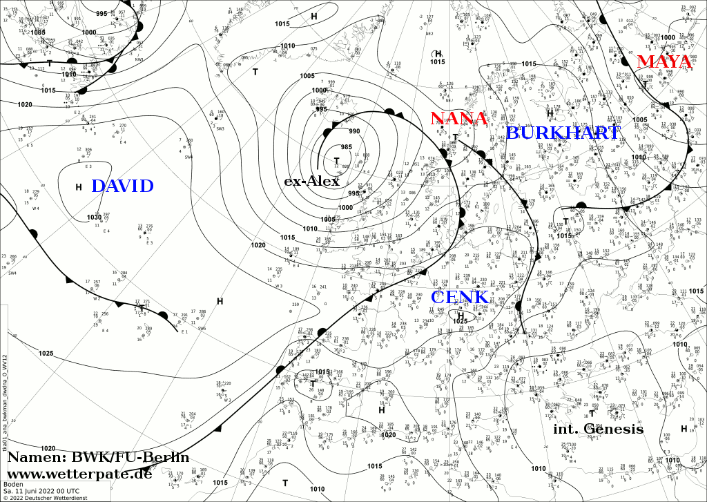
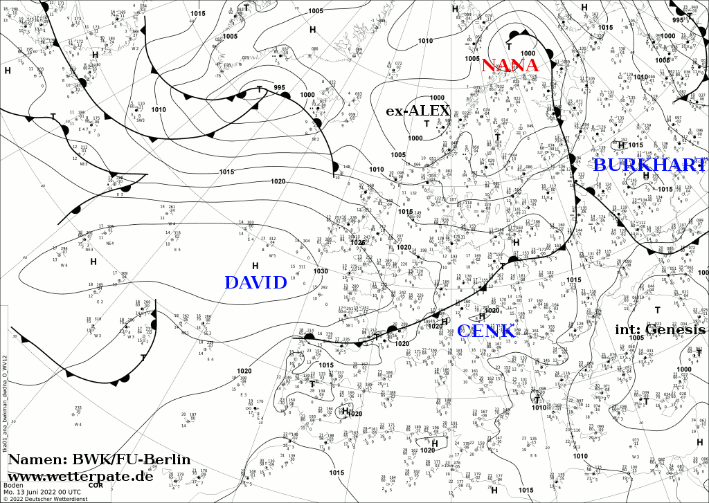
Early on the following day, Hurricane hunters estimated that the system was producing tropical storm-force winds and reported a low-level wind shift, but found no conclusive evidence of a closed circulation. [6] Scatterometer data early on June 4 indicated the system had an elongated region of light winds and still lacked a well-defined center. [7] Shortly after 12:00 UTC, the system struck the west coast of Florida between Cape Coral and Naples. [8] After moving into the Atlantic later on June 4, the system's circulation started to become better defined. [9] [10] At 00:00 UTC on June 5, the disturbance finally established a well-defined center with sufficient convection, becoming Tropical Storm Alex approximately about 85 mi (140 km) north of Grand Bahama Island. Before the day was done, Alex reached its peak intensity with maximum winds of 70 mph (110 km/h) and a minimum central pressure of 984 mbar (29.06 inHg). [11] After peaking, it weakened slightly and began to lose its tropical characteristics. [12] By 12:00 UTC on June 6, the storm had transitioned to a post-tropical cyclone about 105 mi (165 km) north-northwest of Bermuda. Then, 12 hours later, the cyclone was absorbed within a baroclinic zone. A few hours later however, a new area of low pressure formed in association with the deepening trough. And, energized by Alex's remnants, it soon was producing hurricane-force winds as it moved over the central Atlantic, [11] On June 10–11, the new low passed between Iceland and the northern coast of the United Kingdom near the Faroe Islands. [13] [14] Then, it rapidly weakened while moving toward Norway which it reached on June 13. [15]

Preparations and impact

Potential Tropical Cyclone One over South Florida on June 4 01L 2022-06-04 1850Z.jpg
Potential Tropical Cyclone One over South Florida on June 4

Cuba

Upon the initiation of advisories on Potential Tropical Cyclone One at 21:00 UTC on June 2 the government of Cuba issued a tropical storm watch for Artemisa, La Habana, Matanzas, Mayabeque, and Pinar del Rio provinces, as well as Isla de la Juventud. [4] Heavy rain fell throughout western Cuba as the developing storm moved through the Gulf of Mexico, including a 30-hour total of 11.9 in (301 mm) of precipitation in Paso Real de San Diego, in Pinar del Río. The government reported that up to 4,480 people had been displaced in the province. [16] The rains caused the Cuyaguateje River to overflow its banks, in what some longtime residents of Camino Verde, in the municipality of Guane, described as the worst flooding since Hurricane Alberto in 1982. [17] In La Habana, rains caused 61 landslides around Havana. [18] Altogether, there were four storm related fatalities reported in Cuba: two in the Pinar del Río Province and two in Havana. Approximately 750 homes suffered varying degrees of damage, 21 of which were destroyed, and 158,000 customers lost power. Roughly 3,200 hectares (7,900 acres) of crops were damaged. [19]

Florida

The NHC began posting tropical storm watches for Florida, encompassing the state's west coast south of Longboat Key, the east coast from the Brevard Volusia county line southward, Lake Okeechobee, Florida Bay, and the entirety of the Florida Keys. [20] In addition, parts of South Florida were put under a flash flood warning. [21] Likewise, South Florida also experienced heavy rains in association with the precursor of Alex. Several locations observed at least 10 in (250 mm) of precipitation, including preliminary totals of 14.85 in (377 mm) in Hollywood, 14.79 in (376 mm) near Margate, 12.72 in (323 mm) near Biscayne Park, 11.02 in (280 mm) near Palmetto Bay, [22] and at least 11 in (280 mm) in Downtown Miami. [23] Consequently, street flooding occurred in South Florida, especially from Miami-Dade County to southern Palm Beach County, leading to a few road closures and stalling cars, [24] necessitating the rescue of several stranded motorists via the Miami-Dade Fire Rescue Department. [23] The precursor to Alex also generated tropical storm-force wind gusts in the Miami metropolitan area, [24] causing a combined 3,543 power outages in Broward and Miami-Dade counties. [25] In Pompano Beach, winds toppled a large tree onto a mobile home, rendering the residence uninhabitable. [24] Damages across the state from the disturbance totaled $104,000, with Broward County reporting $50,000 in damage from the 40 to 50 miles per hour (64 to 80 km/h) winds. [26] [27]

The Bahamas

The Government of the Bahamas issued a tropical storm watch [20] and then a tropical storm warning for its northwestern islands. [28] The Bermuda Weather Service issued a tropical storm watch for Bermuda, [29] which was raised to a tropical storm warning as the system approached. [30]

See also

Related Research Articles

<span class="mw-page-title-main">Hurricane Michelle</span> Category 4 Atlantic hurricane in 2001

Hurricane Michelle was the fifth costliest tropical cyclone in Cuban history and the strongest hurricane of the 2001 Atlantic hurricane season. The thirteenth named storm and seventh hurricane that year, Michelle developed from a tropical wave that had traversed into the western Caribbean Sea on October 29; the wave had initially moved off the coast of Africa 13 days prior. In its early developmental stages, the depression meandered over Nicaragua, later paralleling the Mosquito Coast before intensifying into tropical storm intensity on November 1; Michelle was upgraded to hurricane strength the following day. Shortly after, rapid intensification ensued within favorable conditions, with the storm's central barometric pressure dropping 51 mbar in 29 hours. After a slight fluctuation in strength, Michelle reached its peak intensity as a Category 4 hurricane with winds of 140 mph (230 km/h) and a minimum pressure of 933 mbar. This tied Michelle with 1999's Lenny as the fourth most powerful November hurricane on record in the Atlantic Basin, behind only the 1932 Cuba hurricane and 2020 Hurricanes Iota and Eta. At roughly the same time, the hurricane began to accelerate northeastward; this brought the intense hurricane to a Cuban landfall within the Bay of Pigs later that day. Crossing over the island, Michelle was weakened significantly, and was only a Category 1 hurricane upon reentry into the Atlantic Ocean. The hurricane later transitioned into an extratropical cyclone over The Bahamas on November 5, before being absorbed by a cold front the following day.

<span class="mw-page-title-main">Tropical Storm Helene (2000)</span> Atlantic tropical storm in 2000

Tropical Storm Helene was a long-lived tropical cyclone that oscillated for ten days between a tropical wave and a 70 mph (110 km/h) tropical storm. It was the twelfth tropical cyclone and eighth tropical storm of the 2000 Atlantic hurricane season, forming on September 15 east of the Windward Islands. After degenerating into a tropical wave, the system produced flooding and mudslides in Puerto Rico. It reformed into a tropical depression on September 19 south of Cuba, and crossed the western portion of the island the next day while on the verge of dissipation. However, it intensified into a tropical storm in the Gulf of Mexico, reaching its peak intensity while approaching the northern Gulf Coast.

<span class="mw-page-title-main">Hurricane Abby (1968)</span> Category 1 Atlantic hurricane in 1968

Hurricane Abby made landfall in Cuba, Florida, and North Carolina in June 1968. The first tropical cyclone, first named storm, and first hurricane on the season, Abby developed over the northwestern Caribbean Sea on June 1, as a result of the interaction between a mid-tropospheric trough and a cold front. Moving generally north-northeastward, the depression slowly strengthened while approaching the western tip of Cuba, becoming Tropical Storm Abby late on June 2. Shortly thereafter, Abby made landfall in Pinar del Río Province. The storm dropped heavy rainfall in western Cuba, with up to 12 inches (300 mm) on Isla de la Juventud. However, no flooding was reported. After reaching the southeastern Gulf of Mexico on June 3, Abby strengthened further and became a Category 1 hurricane on the modern-day Saffir–Simpson hurricane wind scale. However, early on June 4, Abby weakened to a tropical storm. Around midday on June 4, the system made landfall near Punta Gorda, Florida as a strong tropical storm.

<span class="mw-page-title-main">2017 Pacific hurricane season</span> Hurricane season in the Pacific Ocean

The 2017 Pacific hurricane season was an above average Pacific hurricane season in terms of named storms, though less active than the previous three, featuring eighteen named storms, nine hurricanes, and four major hurricanes. Despite the considerable amount of activity, most of the storms were weak and short-lived. The season officially started on May 15 in the eastern Pacific Ocean, and on June 1 in the central Pacific; they both ended on November 30. These dates conventionally delimit the period of each year when most tropical cyclones form in the respective regions. However, the formation of tropical cyclones is possible at any time of the year, as illustrated in 2017 by the formation of the season's first named storm, Tropical Storm Adrian, on May 9. At the time, this was the earliest formation of a tropical storm on record in the eastern Pacific basin proper. The season saw near-average activity in terms of accumulated cyclone energy (ACE), in stark contrast to the extremely active seasons in 2014, 2015, and 2016; and for the first time since 2012, no tropical cyclones formed in the Central Pacific basin. However, for the third year in a row, the season featured above-average activity in July, with the ACE value being the fifth highest for the month. Damage across the basin reached $375.28 million (2017 USD), while 45 people were killed by the various storms.

<span class="mw-page-title-main">Tropical Storm Beryl (2012)</span> Atlantic tropical storm in 2012

Tropical Storm Beryl was the strongest off-season Atlantic tropical cyclone on record to make landfall in the United States. The second tropical cyclone of the 2012 Atlantic hurricane season, Beryl developed on May 26 from a low-pressure system offshore North Carolina. Initially subtropical, the storm slowly acquired tropical characteristics as it tracked across warmer sea surface temperatures and within an environment of decreasing vertical wind shear. Late on May 27, Beryl transitioned into a tropical cyclone less than 120 miles (190 km) from North Florida. Early the following day, the storm moved ashore near Jacksonville Beach, Florida, with peak winds of 65 mph (100 km/h). It quickly weakened to a tropical depression, dropping heavy rainfall while moving slowly across the southeastern United States. A cold front turned Beryl to the northeast, and the storm became extratropical on May 30.

<span class="mw-page-title-main">Tropical Storm Andrea (2013)</span> Atlantic Tropical storm in the 2013

Tropical Storm Andrea brought flooding to Cuba, the Yucatan Peninsula, and portions of the East Coast of the United States in June 2013. The first tropical cyclone and named storm of the annual hurricane season, Andrea originated from an area of low pressure in the eastern Gulf of Mexico on June 5. Despite strong wind shear and an abundance of dry air, the storm strengthened while initially heading north-northeastward. Later on June 5, it re-curved northeastward and approached the Big Bend region of Florida. Andrea intensified and peaked as a strong tropical storm with winds at 65 mph (105 km/h) on June 6. A few hours later, the storm weakened slightly and made landfall near Steinhatchee, Florida later that day. It began losing tropical characteristics while tracking across Florida and Georgia. Andrea transitioned into an extratropical cyclone over South Carolina on June 7, though the remnants continued to move along the East Coast of the United States, until being absorbed by another extratropical system offshore Maine on June 10.

<span class="mw-page-title-main">Hurricane Bertha (2014)</span> Category 1 Atlantic hurricane in 2014

Hurricane Bertha was an unusual tropical cyclone in early August 2014 that attained hurricane status, despite having a disheveled appearance and an abnormally high atmospheric pressure. The third tropical cyclone and second hurricane of the season, Bertha developed from a tropical wave south of Cape Verde was monitored first for possible tropical cyclogenesis on July 26. Over the following days, it slowly developed and acquired gale-force winds and enough convection to be designated as Tropical Storm Bertha early on August 1. A mostly disorganized cyclone, Bertha quickly moved across the Lesser Antilles, clipping the northern end of Martinique, later that day. During its trek across the eastern Caribbean Sea, its circulation became severely disrupted and it may have degenerated into a tropical wave. On August 3, it traversed the Mona Passage and moved over the Southeastern Bahamas where conditions favored development. Despite an overall ragged appearance on satellite imagery, data from Hurricane Hunters indicated it intensified to a hurricane on August 4; it acquired peak winds of 80 mph (130 km/h) that day. Turning north, and later northeast, Bertha soon weakened as it began to merge with an approaching trough to the west. This merger ultimately took place on August 6, at which time Bertha was declared extratropical well to the south of Nova Scotia. The remnant system raced eastward across the Atlantic and later struck the United Kingdom on August 10. Once over the North Sea, the storm stalled for a few days before resuming its eastward track. It was last noted around the Baltic Sea on August 16.

<span class="mw-page-title-main">Hurricane Joaquin</span> Category 4 Atlantic hurricane in 2015

Hurricane Joaquin was a powerful tropical cyclone that devastated several districts of The Bahamas and caused damage in the Turks and Caicos Islands, parts of the Greater Antilles, and Bermuda. It was also the strongest Atlantic hurricane of non-tropical origin recorded in the satellite era. The tenth named storm, third hurricane, and second major hurricane of the 2015 Atlantic hurricane season, Joaquin evolved from a non-tropical low to become a tropical depression on September 28, well southwest of Bermuda. Tempered by unfavorable wind shear, the depression drifted southwestward. After becoming a tropical storm the next day, Joaquin underwent rapid intensification, reaching hurricane status on September 30 and Category 4 major hurricane strength on October 1. Meandering over the southern Bahamas, Joaquin's eye passed near or over several islands. On October 3, the hurricane weakened somewhat and accelerated to the northeast. Abrupt re-intensification ensued later that day, and Joaquin acquired sustained winds of 155 mph (250 km/h), just short of Category 5 strength.

<span class="mw-page-title-main">Tropical Storm Bonnie (2016)</span> Atlantic tropical storm in 2016

Tropical Storm Bonnie was a weak but persistent tropical cyclone that brought heavy rains to the Southeastern United States in May 2016. The second storm of the season, Bonnie formed from an area of low pressure northeast of the Bahamas on May 27, a few days before the official hurricane season began on June 1. Moving steadily west-northwestwards, Bonnie intensified into a tropical storm on May 28 and attained peak winds six hours later. However, due to hostile environmental conditions, Bonnie weakened to a depression hours before making landfall just east of Charleston, South Carolina, on May 29. Steering currents collapsed afterwards, causing the storm to meander over South Carolina for two days. The storm weakened further into a post-tropical cyclone on May 31, before emerging off the coast while moving generally east-northeastwards. On June 2, Bonnie regenerated into a tropical depression just offshore North Carolina as conditions became slightly more favorable. The next day, despite increasing wind shear and cooling sea surface temperatures, Bonnie reintensified into a tropical storm and reached its peak intensity. The storm hung on to tropical storm strength for another day, before weakening into a depression late on June 4 and became post-tropical early the next day.

<span class="mw-page-title-main">Tropical Storm Colin (2016)</span> Atlantic tropical storm in 2016

Tropical Storm Colin was the earliest third named storm in the Atlantic basin on record for four years, until it was surpassed by Tropical Storm Cristobal in 2020. An atypical, poorly organized tropical cyclone, Colin developed from a low pressure area over the Gulf of Mexico near the northern coast of the Yucatán Peninsula late on June 5, 2016. Moving northward, the depression strengthened into a tropical storm about eight hours after its formation. On June 6, Colin curved to the north-northeast and intensified slightly to winds of 50 mph (80 km/h). Strong wind shear prevented further strengthening and resulted in the system maintaining a disheveled appearance on satellite imagery. Later, the storm began accelerating to the northeast. Early on June 7, Colin made landfall in rural Taylor County, Florida, still at peak intensity. The system rapidly crossed northern Florida and emerged into the Atlantic Ocean several hours later. By late on June 7, Colin transitioned into an extratropical cyclone offshore North Carolina before being absorbed by a frontal boundary the following day.

<span class="mw-page-title-main">Meteorological history of Hurricane Harvey</span>

Hurricane Harvey was the costliest tropical cyclone on record, inflicting roughly $125 billion in damage across the Houston metropolitan area and Southeast Texas. It lasted from mid-August until early September 2017, with many records for rainfall and landfall intensity set during that time. The eighth named storm, third hurricane, and first major hurricane of the 2017 Atlantic hurricane season, Harvey originated from a broad area of low pressure southwest of Cape Verde that was first monitored on August 13. Tracking steadily westward, the disturbance developed strong convection, a well-defined circulation, and sustained tropical storm-force winds, leading to the classification of Tropical Storm Harvey late on August 17. Moderate easterly vertical wind shear kept Harvey weak, as it continued westwards into the Caribbean Sea; despite repeated predictions for gradual intensification by the National Hurricane Center, Harvey eventually opened up into a tropical wave on August 19. The remnants of Harvey continued to move westwards and reached the Yucatán Peninsula on August 22, and were forecast to regenerate into a tropical cyclone after exiting land.

<span class="mw-page-title-main">2022 Atlantic hurricane season</span> Hurricane season in the Atlantic Ocean

The 2022 Atlantic hurricane season was a destructive Atlantic hurricane season, which had an average number of named storms, a slightly above-average number of hurricanes, a slightly below-average number of major hurricanes, and a near-average accumulated cyclone energy (ACE) index. Despite this, it became the third-costliest Atlantic hurricane season on record, behind only 2017 and 2005, mostly due to Hurricane Ian. The season officially began on June 1, and ended on November 30. These dates, adopted by convention, historically describe the period in each year when most subtropical or tropical cyclogenesis occurs in the Atlantic Ocean. This year's first Atlantic named storm, Tropical Storm Alex, developed five days after the start of the season, making this the first season since 2014 not to have a pre-season named storm.

<span class="mw-page-title-main">2022 Pacific hurricane season</span> Hurricane season in the Pacific Ocean

The 2022 Pacific hurricane season was an active hurricane season in the eastern North Pacific basin, with nineteen named storms, ten hurricanes, and four major hurricanes. Two of the storms crossed into the basin from the Atlantic. In the central North Pacific basin, no tropical cyclones formed. The season officially began on May 15 in the eastern Pacific, and on June 1 in the central; both ended on November 30. These dates historically describe the period each year when most tropical cyclogenesis occurs in these regions of the Pacific and are adopted by convention.

<span class="mw-page-title-main">Tropical Storm Fernand (2019)</span> 2019 Atlantic tropical storm

Tropical Storm Fernand was a short-lived tropical storm that caused severe flooding in northern Mexico in early September 2019. The sixth named storm of the 2019 Atlantic hurricane season, Fernand developed from a broad area of low pressure that was first monitored in the southeastern Gulf of Mexico on August 31. Gradual organization ensued as the low moved westward, and it developed into a tropical depression early on September 3. The cyclone quickly strengthened into Tropical Storm Fernand six hours after formation, and attained peak winds of 50 mph (80 km/h) early on September 4. However, easterly wind shear and the cyclone's close proximity to the Mexican coast prevented further development, and Fernand weakened slightly before making landfall along the coast of northeastern Mexico at 15:15 UTC September 4. Fernand quickly weakened to a tropical depression as it moved over the Sierra Madre Oriental, and by 03:00 UTC on September 5, the cyclone had dissipated over the rugged terrain of Mexico. Fernand caused torrential, much-needed rainfall in Monterrey and other communities.

<span class="mw-page-title-main">Hurricane Marco (2020)</span> Category 1 Atlantic hurricane in 2020

Hurricane Marco was the first of two tropical cyclones to threaten the Gulf Coast of the United States within a three-day period. The thirteenth named storm and third hurricane of the record-breaking 2020 Atlantic hurricane season, Marco developed from a fast-moving tropical wave west of the Windward Islands and south of Jamaica on August 20. The fast motion of the wave inhibited intensification initially, but as the wave slowed down and entered a more favorable environment, the system developed into a tropical depression, which in turn rapidly intensified into a strong tropical storm. Due to strong wind shear, Marco's intensification temporarily halted. However, after entering the warm waters of the Gulf of Mexico on August 23, Marco briefly intensified into a hurricane, only to quickly weaken later that evening due to another rapid increase in wind shear. Marco subsequently weakened to a tropical depression before degenerating into a remnant low early the next morning. Marco's remnants subsequently dissipated on August 26.

<span class="mw-page-title-main">Tropical Storm Philippe (2017)</span> Atlantic tropical storm in 2017

Tropical Storm Philippe was a weak and disorganized tropical cyclone which caused minimal impacts in Central America, Cuba, and Florida in October 2017. The sixteenth named storm of the extremely-active 2017 Atlantic hurricane season, Philippe originated from the interaction of a tropical wave which exited the coast of West Africa on October 16, and the Central American Gyre on October 24. This formed a broad area of low pressure the next day, that later organized into a tropical depression at 12:00 UTC on October 28. The depression strengthened into Tropical Storm Philippe just six hours later, before making landfall west of the Bay of Pigs in Cuba just a few hours later. Philippe quickly degraded into a tropical depression inland, before dissipating at 0:00 UTC the following day. The remnants later formed into a new low pressure area off the coast of Florida before merging with a cold front, later that same day.

<span class="mw-page-title-main">Tropical Storm Fred (2021)</span> Atlantic tropical storm in 2021

Tropical Storm Fred was a strong tropical storm which affected much of the Greater Antilles and the Southeastern United States in August 2021. The sixth tropical storm of the 2021 Atlantic hurricane season, Fred originated from a tropical wave first noted by the National Hurricane Center on August 4. As the wave drifted westward, advisories were initiated on the wave as a potential tropical cyclone by August 9 as it was approaching the Leeward Islands. Entering the Eastern Caribbean Sea after a close pass to Dominica by the next day, the potential tropical cyclone continued northwestward. By August 11, the disturbance had formed into Tropical Storm Fred just south of Puerto Rico, shortly before hitting the Dominican Republic on the island of Hispaniola later that day. The storm proceeded to weaken to a tropical depression over the highly mountainous island, before emerging north of the Windward Passage on August 12. The disorganized tropical depression turned to the west and made a second landfall in Northern Cuba on August 13. After having its circulation continuously disrupted by land interaction and wind shear, the storm degenerated into a tropical wave as it was turning northward near the western tip of Cuba the following day. Continuing north, the remnants of Fred quickly re-organized over the Gulf of Mexico, regenerating into a tropical storm by August 15. Fred continued towards the Florida Panhandle and swiftly intensified to a strong 65 mph (105 km/h) tropical storm before making landfall late on August 16 and moving into the state of Georgia. Afterward, Fred continued moving north-northeastward, before degenerating into an extratropical low on August 18. Fred's remnants later turned eastward, and the storm's remnants dissipated on August 20, near the coast of Massachusetts.

<span class="mw-page-title-main">Hurricane Olaf (2021)</span> Category 2 Pacific hurricane in 2021

Hurricane Olaf was a Category 2 Pacific hurricane that struck the Baja California Peninsula in September 2021. The fifteenth named storm and sixth hurricane of the 2021 Pacific hurricane season, the cyclone formed from an area of low pressure that developed off the southwestern coast of Mexico on September 5, 2021. The disturbance developed within a favorable environment, acquiring more convection and a closed surface circulation. The disturbance developed into Tropical Depression Fifteen-E by 18:00 UTC on September 7. The depression strengthened into a tropical storm and was named Olaf at 12:00 UTC the next day. Olaf quickly strengthened as it moved to the north-northwest, and was upgraded to a hurricane 24 hours after being named. Hurricane Olaf continued to intensify and reached peak intensity while its center was just offshore the southwestern coast of Baja California Sur, with maximum sustained winds of 105 mph (169 km/h) and a minimum barometric pressure of 975 mbar (28.8 inHg). Just after reaching peak intensity, the hurricane made landfall near San José del Cabo. Interaction with the mountainous terrain of the Baja California Peninsula caused Olaf to quickly weaken. It was downgraded to a tropical storm at 12:00 UTC on September 10. The system became devoid of convection later that day and degenerated to a remnant low by 06:00 UTC on September 11.

<span class="mw-page-title-main">Hurricane Bonnie (2022)</span> Category 3 Atlantic and Pacific hurricane in 2022

Hurricane Bonnie was a strong tropical cyclone that survived the crossover from the Atlantic Ocean to the Pacific Ocean, the first to do so since Hurricane Otto in 2016. The second named storm of the 2022 Atlantic hurricane season, it originated from a strong tropical wave that moved off the west coast of Africa on June 23. Moving with little development despite favorable conditions, the National Hurricane Center (NHC) started advisories on it as Potential Tropical Cyclone Two late on June 27, due to its imminent threat to land. The disturbance finally organized into Tropical Storm Bonnie at 13:15 UTC on July 1, and made brief landfalls on the Costa Rica–Nicaragua border with winds of 50 miles per hour (80 km/h). It later became the fourth named storm, third hurricane, and first major hurricane of the 2022 Pacific hurricane season after crossing Nicaragua and Costa Rica from east to west on July 2 and intensifying to a Category 3 hurricane on July 5. Bonnie rapidly weakened, dissipating over the North Pacific.

<span class="mw-page-title-main">Hurricane Beatriz (2023)</span> Category 1 Pacific hurricane in 2023

Hurricane Beatriz was a Category 1 Pacific hurricane that caused widespread flooding along much of the Pacific coast of southwestern Mexico in late June and early July 2023. The second named storm and second hurricane of the 2023 Pacific hurricane season, Beatriz developed from an area of low pressure that first formed offshore of southern Mexico on June 25. The disturbance was slow to organize, but due to the impending threat it posed to the Mexican coast, advisories were initiated on it as Potential Tropical Cyclone Two-E at 03:00 UTC on June 29. The system organized into a tropical depression six hours later. Later that day, the depression strengthened into a tropical storm and was named Beatriz. Closely paralleling the coast of Mexico, Beatriz rapidly intensified into a hurricane at 15:00 UTC on June 30. The storm peaked in intensity shortly after with maximum sustained winds of 85 mph (137 km/h) and a minimum barometric pressure of 992 mbar (29.3 inHg). Early on July 1, the hurricane's center brushed the coast near Punta San Telmo, after which it steadily lost organization. Beatriz weakened to a tropical storm shortly thereafter, and the system dissipated entirely by 18:00 UTC that day offshore of Cabo Corrientes.

References

  1. "2022 Hurricane Season Officially Begins With 'Above-Normal' Storm Expectations". Miami, Florida: WTVJ. June 1, 2022. Retrieved October 28, 2022.
  2. Papin, Philippe (May 31, 2022). Tropical Weather Outlook (Report). Miami, Florida: National Hurricane Center. Retrieved June 2, 2022.
  3. Beven, Jack (June 2, 2022). Tropical Weather Outlook (Report). Miami, Florida: National Hurricane Center. Retrieved June 2, 2022.
  4. 1 2 Beven, Jack (June 2, 2022). Potential Tropical Cyclone One Advisory Number 1 (Report). Miami, Florida: National Hurricane Center. Retrieved June 2, 2022.
  5. Latto, Andy; Cangialosi, John (May 31, 2022). Potential Tropical Cyclone One Discussion Number 2 (Report). Miami, Florida: National Hurricane Center. Retrieved June 2, 2022.
  6. Berg, Robbie (June 3, 2022). Potential Tropical Cyclone One Discussion Number 3 (Report). Miami, Florida: National Hurricane Center. Retrieved June 3, 2022.
  7. Berg, Robbie (June 4, 2022). Potential Tropical Cyclone One Discussion Number 7 (Report). Miami, Florida: National Hurricane Center. Retrieved June 4, 2022.
  8. Beven, Jack (June 4, 2022). Potential Tropical Cyclone One Intermediate Advisory Number 7A (Report). Miami, Florida: National Hurricane Center. Retrieved June 6, 2022.
  9. Beven, Jack (June 4, 2022). Potential Tropical Cyclone One Discussion Number 9 (Report). Miami, Florida: National Hurricane Center. Retrieved June 5, 2022.
  10. Beven, Jack (June 4, 2022). Potential Tropical Cyclone One Discussion Number 8 (Report). Miami, Florida: National Hurricane Center. Retrieved June 4, 2022.
  11. 1 2 Brown, Daniel; Delgado, Sandy (October 26, 2022). Tropical Cyclone Report: Tropical Cyclone Alex (PDF) (Report). Miami, Florida: National Hurricane Center . Retrieved October 28, 2022.
  12. Papin, Philippe; Blake, Eric (June 6, 2022). Tropical Storm Alex Discussion Number 15 (Report). Miami, Florida: National Hurricane Center. Retrieved June 7, 2022.
  13. Single Location Forecast - 7 Day. orkneyharbours.com (Report). June 11, 2022. Archived from the original on June 12, 2022. Retrieved June 11, 2022.
  14. Deutscher Wetterdienst (June 11, 2022). "Analyse of 00 UTC on June 11 2022" (in German). Free University of Berlin . Retrieved June 13, 2022.
  15. Deutscher Wetterdienst (June 13, 2022). "Analyse of 00 UTC on June 13 2022" (in German). Free University of Berlin . Retrieved June 13, 2022.
  16. Davies, Richard (June 4, 2022). "Cuba – Deadly Flash Floods After 300mm of Rain". floodlist.com. Archived from the original on June 4, 2022. Retrieved June 6, 2022.
  17. Corbillón Díaz, Evelyn (June 3, 2022). "Reporta Pinar del Río lluvias significativas y se mantiene alerta" [Pinar del Río reports significant rains and remains alert]. ACN (in Spanish). Archived from the original on June 4, 2022. Retrieved June 6, 2022.
  18. "Una tormenta deja al menos tres muertos y miles de evacuados en Cuba e inundaciones en Miami" [A storm leaves at least three dead and thousands of evacuees in Cuba and floods in Miami]. La Vanguardia (in Spanish). June 4, 2022. Archived from the original on June 5, 2022. Retrieved June 6, 2022.
  19. "Tormenta Alex causa estragos: Elevan a cuatro los muertos en Cuba por las fuertes lluvias" [Storm Alex wreaks havoc: Deaths in Cuba rise to four due to heavy rains] (in Spanish). El Diario. EFE. June 6, 2022. Archived from the original on June 27, 2022. Retrieved June 22, 2022.
  20. 1 2 Latto, Andy; Cangialosi, John (June 2, 2022). Potential Tropical Cyclone One Intermediate Advisory 1A (Report). Miami, Florida: National Hurricane Center. Retrieved June 6, 2022.
  21. Cohen, Howard (June 4, 2022). "With rain totals mounting, a flash flood warning has been extended in South Florida". Miami Herald. Archived from the original on June 4, 2022. Retrieved June 4, 2022.
  22. Public Information Statement...Corrected. National Weather Service Weather Forecast Office in Miami, Florida (Report). Iowa Environmental Mesonet. June 5, 2022. Archived from the original on June 7, 2022. Retrieved June 6, 2022.
  23. 1 2 "Flooding Across South Florida After Tropical System Dumps Heavy Rain". NBC Miami. June 4, 2022. Archived from the original on June 4, 2022. Retrieved June 4, 2022.
  24. 1 2 3 Preliminary Local Storm Report...Summary. National Weather Service Weather Forecast Office in Miami, Florida (Report). Iowa Environmental Mesonet. June 5, 2022. Archived from the original on June 7, 2022. Retrieved June 6, 2022.
  25. Sosa, Samantha (June 4, 2022). "Areas of South Florida impacted by flooding due to heavy rains". WSVN Miami. Archived from the original on June 4, 2022. Retrieved June 4, 2022.
  26. Storm Events Database: Search Results for All Counties in Florida (June 3–6, 2022) (Report). Ashville, North Carolina: National Centers for Environmental Information. Retrieved October 28, 2022.
  27. "Florida Event Report: Broward County Thunderstorm Wind". National Centers for Environmental Information. Retrieved May 17, 2023.
  28. Berg, Robbie (June 3, 2022). Potential Tropical Cyclone One Advisory Number 3 (Report). Miami, Florida: National Hurricane Center. Retrieved June 6, 2022.
  29. Beven, Jack (June 4, 2022). Potential Tropical Cyclone One Advisory Number 8 (Report). Miami, Florida: National Hurricane Center. Retrieved June 6, 2022.
  30. Papin, Phillipe; Blake, Eric (June 5, 2022). Tropical Storm Alex Advisory Number 11 (Report). Miami, Florida: National Hurricane Center. Retrieved June 6, 2022.
Tropical Storm Alex
Alex 2022-06-05 1755Z.jpg
Tropical Storm Alex at peak intensity west of Bermuda on June 5