The Gulf of Papua is a 400 kilometer wide region on the south coast of New Guinea.

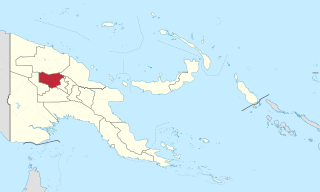
Enga is one of the provinces in Papua New Guinea (PNG). It is located in the north most region of the highlands of PNG, having been divided from the Western Highlands to become a separate province when the provinces were created at the time of independence in 1975. The people of Enga are called Engans—they are a majority ethnic group—speaking one language in all its five districts: approximately 500,000 people. A small minority of Engans' land on the eastern side of the region remained in the Western Highlands, their territory being accessible by road from Mount Hagen but not directly from elsewhere in Enga territory.

Gulf Province is a province of Papua New Guinea located on the southern coast. The provincial capital is Kerema. The 34,472 km² province is dominated by mountains, lowland river deltas, and grassland flood plains, the Kikori, Turama, Purari and Vailala rivers all meet the sea known as the Papuan Gulf. The province has the second-smallest population of all the provinces of Papua New Guinea with 106,898 inhabitants. The province shares land borders with Western Province to the west, Southern Highlands, Chimbu, and Eastern Highlands to the north, Morobe Province to the east, and Central Province to the southeast.

Eastern Highlands is a highlands province of Papua New Guinea. The provincial capital is Goroka. The province covers an area of 11,157 km², and has a population of 579,825. The province shares a common administrative boundary with Madang Province to the north, Morobe Province to the east, Gulf Province to the south, and Simbu Province to the west. The province is the home of the Asaro mud mask that is displayed at shows and festivals within the province and in the country. It is reachable by air and road transport.

The Purari is a river in that originates in the south central highlands especially in Kandep District of Enga Province of Papua New Guinea, flowing 470 kilometres (292 mi) though the Gulf Province to the Gulf of Papua. The Purari has a 33,670 km2 (13,000 sq mi) drainage basin and is the third largest river in Papua New Guinea.
Chimbu River is a river in the Chimbu Province of Papua New Guinea. The Chimbu is a tributary of the Tua.

Mendi, Papua New Guinea, is the provincial capital of the Southern Highlands Province. The Lai River flows by the town. It is served by Mendi Airport. The town falls under Mendi Urban LLG.
Dadibi is a language of Papua New Guinea. In 2001, the whole Bible was translated into Dadibi.
Purari (Namau) is a Papuan language of Papua New Guinea.
Asaro River is a river in Eastern Highlands province, Papua New Guinea, located at 6.3666667°S 145.2°E. The Asaro is a tributary of the Tua.

The Great Papuan Plateau is a karst plateau in the Southern Highlands, Hela and Western Provinces of Papua New Guinea. It is bordered the upper stretches of the Kikori River and the Strickland River on the east and west, respectively, and the Karius Range, the southern edge of the highlands, including Mount Sisa, to the north, and Mount Bosavi to the south.

The Teberan languages are a well established family of Papuan languages that Stephen Wurm (1975) grouped with the Pawaia language as a branch of the Trans–New Guinea phylum.
The Wiru are a people of the Southern Highlands Province of Papua New Guinea. They speak the Wiru language. Among their rituals is the production of timbuwarra out of rattan.

Wiru or Witu is the language spoken by the Wiru people of Ialibu-Pangia District of the Southern Highlands Province of Papua New Guinea.

Pawaia, also known as Sira, Tudahwe, Yasa, is a Papuan language that forms a tentative independent branch of the Trans–New Guinea family in the classification of Malcolm Ross (2005).
Pilikambi Rural LLG is one of the four Local-Level Government Areas (LLGs) of Lagaip Porgera Electorate in Enga Province, Papua New Guinea. The other three LLGs in the district are Maip-Mulitaka Rural, Paiela-Hewa Rural and Porgera.

Lamari River is a river that originates in Kratke Range in the south central highlands of Eastern Highlands Province of Papua New Guinea. It flows into the Purari River basin.

Karimui Rural LLG is a local-level government (LLG) of Chimbu Province, Papua New Guinea.


