Related Research Articles

Papua New Guinea, officially the Independent State of Papua New Guinea, is a sovereign state in Oceania that occupies the eastern half of the island of New Guinea and its offshore islands in Melanesia, a region of the southwestern Pacific Ocean north of Australia. Its capital, located along its southeastern coast, is Port Moresby. The western half of New Guinea forms the Indonesian provinces of Papua and West Papua. It is the world's third largest island country with 462,840 km2 (178,700 sq mi).

The geography of Papua New Guinea describes the eastern half of the island of New Guinea, the islands of New Ireland, New Britain and Bougainville, and smaller nearby islands. Together these make up the nation of Papua New Guinea in tropical Oceania, located in the western edge of the Pacific Ocean.

New Britain is the largest island in the Bismarck Archipelago, part of the Islands Region of Papua New Guinea. It is separated from New Guinea by a northwest corner of the Solomon Sea and from New Ireland by St. George's Channel. The main towns of New Britain are Rabaul/Kokopo and Kimbe. The island is roughly the size of Taiwan. While the island was part of German New Guinea, it was named Neupommern.

Bougainville Island is the main island of the Autonomous Region of Bougainville of Papua New Guinea. It formed the main landmass of the German Empire-associated North Solomons. Its land measures 9,300 km2 (3,600 sq mi). The population of the province is approximately 300,000, which includes islets such as the Carterets. Mount Balbi on the main island at 2,715 m (8,907 ft) is the highest point. Much smaller Buka Island, c. 500 km2 (190 sq mi) lies north across the 400–500 m (1,300–1,600 ft) wide Buka strait. The Buka strait, despite its narrowness, is unbridged; however, regular ferries operate between the key settlements on either side and Buka Town has the main northern airstrip/airport.
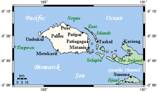
New Hanover Island,, also called Lavongai, is a large volcanic island in the New Ireland Province of Papua New Guinea. This region is part of the Bismarck Archipelago and lies at 2.5°S 150.25°E. Measuring some 460 square miles (1,200 km2), it had a population of 5,000 in 1960, which increased to approximately 17,160 by 2000.

The Bismarck Sea lies in the southwestern Pacific Ocean within the nation of Papua New Guinea. It is located northeast of the island of New Guinea and south of the Bismarck Archipelago. It has coastlines in districts of the Islands Region, Momase Region, and Papua Region.

Education in Papua New Guinea is managed through nineteen provinces and two district organisational units. It is tuition-free and attendance is not compulsory. With a literacy rate of 64.2%, Papua New Guinea has the lowest literacy rate in Oceania.
The Solomon Sea is a sea located within the Pacific Ocean. It lies between Papua New Guinea and the Solomon Islands. Many major battles were fought there during World War II.
The Territory of New Guinea was an Australian administered territory on the island of New Guinea from 1914 until 1975. In 1949, the Territory and the Territory of Papua were established in an administrative union by the name of the Territory of Papua and New Guinea. That administrative union was renamed as Papua New Guinea in 1971. Notwithstanding that it was part of an administrative union, the Territory of New Guinea at all times retained a distinct legal status and identity until the advent of the Independent State of Papua New Guinea.
The Ata language, also known as Pele-Ata after its two dialects, or Wasi, is a Papuan language spoken on New Britain island, Papua New Guinea. It appears to be related to neighboring Anêm, and possibly also to Yélî Dnye in a proposed Yele-West New Britain family. There are about 2000 speakers.

Nukumanu, formerly Tasman Islands, is an atoll of Papua New Guinea, located in the Southwestern Pacific Ocean, 4 degrees south of the equator.

New Ireland or Latangai, is a large island in Papua New Guinea, approximately 7,404 km2 (2,859 sq mi) in area with c. 120,000 people. It is named after the island of Ireland. It is the largest island of New Ireland Province, lying northeast of the island of New Britain. Both islands are part of the Bismarck Archipelago, named after Otto von Bismarck, and they are separated by Saint George's Channel. The administrative centre of the island and of New Ireland province is the town of Kavieng located at the northern end of the island. While the island was part of German New Guinea, it was named Neumecklenburg.

New Guinea is the world's second-largest island and, with an area of 785,753 km2 (303,381 sq mi), the largest island wholly or partly within the Southern Hemisphere and Oceania. Located in Melanesia in the southwestern Pacific Ocean, it is separated by the 150-kilometre wide Torres Strait from the Australian continent. Numerous smaller islands are located to the west and east. The eastern half of the island is the major land mass of the independent state of Papua New Guinea. The western half, known as Western New Guinea or West Papua, forms a part of Indonesia and is organized as the provinces of Papua and West Papua.
Telefol is a language spoken by the Telefol people in Papua New Guinea, notable for possessing a base-27 numeral system.
Tatau Island is an island of the Tabar Group of Papua New Guinea, located to the east of New Ireland and about a mile south of Simberi Island.
Tsoilaunung Island is an island of Papua New Guinea, located to the east of New Hanover Island, to the north of New Ireland. The island is also known as Tsoi. Senta Pass separates it from Patio Island to its south.
Patio Island is a small island of Papua New Guinea, located to the southeast of New Hanover Island, to the north-west of New Ireland. Senta Pass separates it from Tsoilaunung Island to the north. To the south is Baudisson Island.
Selapiu Island is an island of Papua New Guinea, located immediately south of the corner of New Hanover Island. According to the United States Naval Oceanographic Office, a "cylindrical concrete beacon, surmounted by a pole and a square, 23 feet (7 m) high, marks the south edge of the reef that extends from the east extremity of Selapiu Island." Its highest point is 409 feet (125 m).
Manne Island is an island of Papua New Guinea, located of the north-west coast of New Ireland. It is located east of Baudisson Island; Balgai Bay separates it from the town of Kavieng on the northern tip of New Ireland.
The Lossuk is a river of north-western New Ireland, Papua New Guinea. The sedimentation and mineral deposits of the river was studied in the mid 1980s.
References
- ↑ Marlow, Michael S. (1988). Geology and offshore resources of Pacific island arcs--New Ireland and Manus Region, Papua New Guinea. Circum-Pacific Council for Energy and Mineral Resources. ISBN 978-0-933687-10-3 . Retrieved 1 January 2013.
Coordinates: 2°41′S150°58′E / 2.683°S 150.967°E
| This article related to a river in Papua New Guinea is a stub. You can help Wikipedia by expanding it. |