
6°S147°E

The prehistory of Papua New Guinea can be traced to about 50,000 - 60,000 years ago, when people first migrated towards the Australian continent. The written history began when European navigators first sighted New Guinea in the early part of the 17th century.
The Sko or Skou languages are a small language family spoken by about 7000 people, mainly along the Vanimo coast of Sandaun Province in Papua New Guinea, with a few being inland from this area and at least one just across the border in the Indonesian province of Papua.
Amto–Musan is a language family of two closely related but mutually unintelligible Papuan languages, Amto and Siawi, spoken along the Samaia River of Sandaun Province of Papua New Guinea.

4°00′S136°00′E

East Sepik is a province in Papua New Guinea. Its capital is Wewak. East Sepik has an estimated population of 433,481 people and is 43,426 km square in size.

The East Geelvink Bay or East Cenderawasih languages are a language family of a dozen Papuan languages along the eastern coast of Geelvink Bay in Indonesian Papua, which is also known as Sarera Bay or Cenderawasih.
The Left May or Arai languages are a small language family of half a dozen closely related but not mutually intelligible languages in the centre of New Guinea, in the watershed of the Left May River. There are only about 2,000 speakers in all. Foley (2018) classifies them separately as an independent language family, while Usher (2020) links them with the Amto–Musan languages.
The Busa language, also known as Odiai (Uriai), is spoken in three hamlets of northwestern Papua New Guinea. There were 244 speakers at the time of the 2000 census. One of the hamlets where Busa is spoken is Busa in Rawei ward, Green River Rural LLG, Sandaun Province.

Papua New Guinea, a sovereign state in Oceania, is the most linguistically diverse country in the world. According to Ethnologue, there are 839 living languages spoken in the country. In 2006, Papua New Guinea Prime Minister Sir Michael Somare stated that "Papua New Guinea has 832 living languages ." Languages with statutory recognition are Tok Pisin, English, Hiri Motu, and Papua New Guinean Sign Language. Tok Pisin, an English-based creole, is the most widely spoken, serving as the country's lingua franca. Papua New Guinean Sign Language became the fourth officially recognised language in May 2015, and is used by the deaf population throughout the country.
Amto is an Amto–Musan language spoken in Sandaun Province of Papua New Guinea.
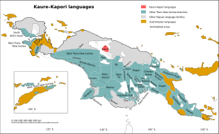
The Kaure–Kosare or Nawa River languages are a small family spoken along the Nawa River in West Papua, near the northern border with Papua New Guinea. The languages are Kaure and Kosare.

The Turama–Kikorian languages are a family identified by Arthur Capell (1962) and part of the Trans–New Guinea languages (TNG) family in the classifications of Stephen Wurm (1975) and Malcolm Ross (2005). The family is named after the Turama River and Kikori River of southern Papua New Guinea; the alternative name is based more narrowly on the Omati River.

New Guinea is the world's second-largest island with an area of 785,753 km2 (303,381 sq mi). Located in Oceania in the southwestern Pacific Ocean, the island is separated by the 150 km wide Torres Strait from Australia. Numerous smaller islands are located to the west and east. The eastern half of the island is the major land mass of the independent state of Papua New Guinea. The western half, known as Western New Guinea, forms a part of Indonesia and is organized as the provinces of Papua and West Papua. The largest cities on the island are Jayapura and Port Moresby.

The Senu River languages are a small language family spoken in the Senu River watershed of Papua New Guinea. They consist at least of the Kwomtari languages, Kwomtari and Nai, with several additional languages more distantly related to them.

The Yam languages, also known as the Morehead River languages, are a family of Papuan languages. They include many of the languages south and west of the Fly River in Papua New Guinea and Indonesian West Papua.
The Iwam languages are a small family of two clearly related languages,

The Sepik River is the longest river on the island of New Guinea, and the second largest in Oceania by discharge volume after the Fly River. The majority of the river flows through the Papua New Guinea (PNG) provinces of Sandaun and East Sepik, with a small section flowing through the Indonesian province of Papua.
The South Pauwasi languages are a likely small language family of New Guinea, potentially consisting of Yetfa, Kimki, Lepki, Murkim and Kembra.
Arai–Samaia is a language family of New Guinea, proposed by Timothy Usher, that includes the Arai and Samaia (Amto–Musan) languages and the Pyu isolate.
