
6°S147°E

The prehistory of Papua New Guinea can be traced to about 50,000 - 60,000 years ago, when people first migrated towards the Australian continent. The written history began when European navigators first sighted New Guinea in the early part of the 17th century.
The Sko or Skou languages are a small language family spoken by about 7000 people, mainly along the Vanimo coast of Sandaun Province in Papua New Guinea, with a few being inland from this area and at least one just across the border in the Indonesian province of Papua.

4°00′S136°00′E

Western Province is a coastal province in southwestern Papua New Guinea, bordering the Indonesian province of Papua. The provincial capital is Daru. The largest town in the province is Tabubil. Other major settlements are Kiunga, Ningerum, Olsobip and Balimo.

East Sepik is a province in Papua New Guinea. Its capital is Wewak. East Sepik has an estimated population of 433,481 people and is 43,426 km square in size.

The Trans-Fly – Bulaka RiverakaSouth-Central Papuan languages form a hypothetical family of Papuan languages. They include many of the languages west of the Fly River in southern Papua New Guinea into southern Indonesian West Papua, plus a pair of languages on the Bulaka River a hundred km further west.
The Border or Upper Tami languages are an independent family of Papuan languages in Malcolm Ross's version of the Trans–New Guinea proposal.

The striped grunter is a species of freshwater ray-finned fish, a grunter from the family Terapontidae. It is found only in the Bewani Mountains in the headwaters of the Pual River system in Papua New Guinea and the upper Sermowai River, Western new Guinea, Indonesia. It is found in high altitude, fast flowing mountains streams. The males guard and fan the eggs.
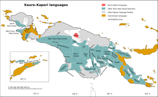
The Kaure–Kosare or Nawa River languages are a small family spoken along the Nawa River in West Papua, near the northern border with Papua New Guinea. The languages are Kaure and Kosare.

The Turama–Kikorian languages are a family identified by Arthur Capell (1962) and part of the Trans–New Guinea languages (TNG) family in the classifications of Stephen Wurm (1975) and Malcolm Ross (2005). The family is named after the Turama River and Kikori River of southern Papua New Guinea; the alternative name is based more narrowly on the Omati River.

The Southeast Papuan or Papuan Peninsula languages are a group of half a dozen small families of Papuan languages in the "Bird's Tail" of New Guinea that are part of the Trans–New Guinea (TNG) phylum.

New Guinea is the world's second-largest island with an area of 785,753 km2 (303,381 sq mi). Located in Oceania in the southwestern Pacific Ocean, the island is separated by the 150 km wide Torres Strait from Australia. Numerous smaller islands are located to the west and east. The eastern half of the island is the major land mass of the independent state of Papua New Guinea. The western half, known as Western New Guinea, forms a part of Indonesia and is organized as the provinces of Papua and West Papua. The largest cities on the island are Jayapura and Port Moresby.

The Yam languages, also known as the Morehead River languages, are a family of Papuan languages. They include many of the languages south and west of the Fly River in Papua New Guinea and Indonesian West Papua.

The Sepik River is the longest river on the island of New Guinea, and the second largest in Oceania by discharge volume after the Fly River. The majority of the river flows through the Papua New Guinea (PNG) provinces of Sandaun and East Sepik, with a small section flowing through the Indonesian province of Papua.

Pawaia, also known as Sira, Tudahwe, Yasa, is a Papuan language that forms a tentative independent branch of the Trans–New Guinea family in the classification of Malcolm Ross (2005).
Mandobo, or Kaeti, is a Papuan language of Mandobo District in Boven Digoel Regency, Papua, Indonesia.
The South Pauwasi languages are a likely small language family of New Guinea, potentially consisting of Yetfa, Kimki, Lepki, Murkim and Kembra.

The Papuan Gulf languages are a proposed language family of Papuan languages spoken inland from the large gulf that defines the shape of southern Papua New Guinea.
