| Apmi River | |
|---|---|
 Location of mouth | |
| Location | |
| Country | Papua New Guinea |
| Island | New Britain |
The Apmi is a river of central western New Britain, in Papua New Guinea. [1]
| Apmi River | |
|---|---|
| Location of mouth | |
| Location | |
| Country | Papua New Guinea |
| Island | New Britain |
The Apmi is a river of central western New Britain, in Papua New Guinea. [1]

Sangerfield is a town in Oneida County, New York, United States. The population was 2,561 at the 2010 census. The town is named after Jedediah Sanger, an early settler.

Ridgeville is an unincorporated community in central Clearcreek Township, Warren County, Ohio, United States. It is located on State Route 48 in the north central part of the county, in sections 30 and 36, T4R4, Between the Miami Rivers Survey.
Roberta "Bobbie" Kevelson was an American academic and semiotician. She was an acknowledged authority on the pragmatism theories of Charles Sanders Peirce.

Charlotte is the largest parish of Saint Vincent and the Grenadines, situated on the eastern coast of the island of Saint Vincent. With an area of 149 km², its size is comparable to that of the British Virgin Islands.) The parish has the longest coastline of all the parishes and is also larger than the three smallest parishes combined. The parish possesses a very rough and rugged topography with very little flat land occurring towards the coast. as a result of these features, parts of the north of the parish cannot be accessed by a main road. Up until the building of a bridge over the Rabacca Dry River access to the north side of the river was not possible when rain caused the river to swell and make the path impassable.
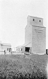
Benito is an unincorporated rural community in the Municipality of Swan Valley West within the Canadian province of Manitoba that held village status prior to January 1, 2015. The community is situated in the Swan River Valley, 37 kilometres southwest of Swan River, 475 kilometres northwest of Winnipeg, and 2 kilometres east of the Saskatchewan border. To the south is Duck Mountain Provincial Park and Forest, to the north is Thunder Hill and further north of Swan River is Porcupine Mountain Provincial Park. Benito is served by PTH 83.

Vojníkov is a small village in the South Bohemian region in Písek District, Czech Republic. It is located about 6 km (3.7 mi) north of Písek. It is divided into three parts: Vojníkov, Držov and Louka, and the village is situated where the routes from Otava mills and other villages intersect. The village has a history that extends for several centuries, as other settlements in Czech lands have. In the western part of the territory of the village the Otava river can be seen. Its valley, namely the part near Vojníkov, has been a location where cottages and recreational areas have been built since the 1950s, used mostly by people working in Písek as well as from Prague, České Budějovice, or Strakonice.. These facilities include a pub and campgrounds.

Caerwedros is a small village in western Ceredigion, Wales, in the community of Llandysiliogogo.
Carlos Gomes is a municipality in the state of Rio Grande do Sul, Brazil. As of 2020, the estimated population was 1,351.
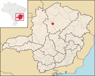
Ibiaí is a Brazilian municipality located in the north of the state of Minas Gerais. In 2020 the population was 8,437 in a total area of 870 km². It became a municipality in 1963.

Yorkville is an unincorporated community in Mendocino County, California. It is located 7.5 miles (12 km) southwest of Hopland, at an elevation of 922 feet.

Warriner Island is a small ice-free island in the Donskiye Islands group lying just off the west end of Breidnes Peninsula in the Vestfold Hills, off the coast of East Antarctica. It is 1.2 km long by 0.7 km wide, reaching an elevation of 52 m.

The Plaça de Sant Jaume is a square at the center of the Old City of Barcelona and the administrative heart of both the city and surrounding Catalonia. This is because the Palace of the Generalitat of Catalonia and the City Hall are located here across from one another.
Ojibways of Onigaming First Nation is an Ojibwe or Ontario Saulteaux First Nation located in Kenora District, Ontario near Nestor Falls, Ontario. Together with the Big Grassy First Nation, Ojibways of Onigaming First Nation is a successor apparent to the former Assabaska Band of Saulteaux. Total registered population in February, 2012, was 737, of which the on-reserve population was 445. The First Nation is a member of the Anishinabeg of Kabapikotawangag Resource Council, a regional tribal council that is a member of the Grand Council of Treaty 3.
The Back River, a perennial stream of the Tuross River catchment, is located in the Monaro and South Coast regions of New South Wales, Australia.
The Lunenburgh River is a perennial river in the South West region of Western Australia.

China Pharmaceutical University station, is a station of Line 1 of the Nanjing Metro. It began operations on 28 May 2010, as part of the southern extension of line 1 from Andemen to this station. The rail depot for the southern extension of Line 1 is located to the west of the station.

Veintiséis de Octubre District is one of the districts of the province Piura in Peru. On February 2, 2013 the president of Peru Ollanta Humala Tasso promulgated the law Ley 29991 of territorial demarcation and organization of the province of Piura, which in its second article created the district Veintiséis de Octubre.

Sandy Bend is an unincorporated community in Cowlitz County, Washington, south of the city of Castle Rock, west of Washington State Route 411, and to the west of the Cowlitz River. Sandy Bend is located along or near Sandy Bend Road between Castle Rock and West Side Highway. The Sandy Bend community is part of the Castle Rock School District, a K-12 school district of about 1,300 students.
New Survey is an unincorporated community in Pemiscot County, in the U.S. state of Missouri.
Coordinates: 5°54′50″S149°10′37″E / 5.91389°S 149.17694°E