Related Research Articles

The country of Brazil occupies roughly half of South America, bordering the Atlantic Ocean. Brazil covers a total area of 8,514,215 km2 (3,287,357 sq mi) which includes 8,456,510 km2 (3,265,080 sq mi) of land and 55,455 km2 (21,411 sq mi) of water. The highest point in Brazil is Pico da Neblina at 2,994 m (9,823 ft). Brazil is bordered by the countries of Argentina, Bolivia, Colombia, Guyana, Paraguay, Peru, Suriname, Uruguay, Venezuela, and France.

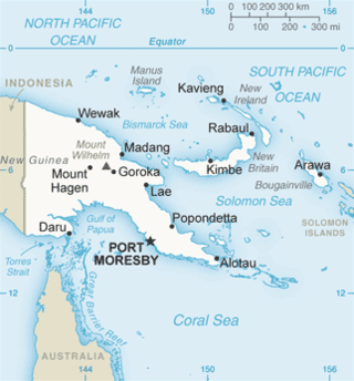
The Gulf of Papua is located in the southern coast region of New Guinea. It has a total surface area of 70,400 km2 (27,200 sq mi).

The Purari is a river that originates in the south central highlands especially in Kandep District of Enga Province of Papua New Guinea, flowing 630 kilometres (391 mi) though Gulf Province to the Gulf of Papua. The Purari has a 33,670 km2 (13,000 sq mi) drainage basin and is the third largest river in Papua New Guinea. The discharge varies through the year, averaging around 3,000 m3/s (110,000 cu ft/s)–4,000 m3/s (140,000 cu ft/s) at the delta.
Chimbu River is a river in the Chimbu Province of Papua New Guinea. The Chimbu is a tributary of the Tua.
Mendi, Papua New Guinea, is the provincial capital of the Southern Highlands Province. The Lai River flows by the town. It is served by Mendi Airport. The town falls under Mendi Urban LLG.

The Musi River is a river in Southern Sumatra, Indonesia. It flows from south-west to north-east, from the Barisan Mountains range that form the backbone of Sumatra, in Kepahiang Regency, Bengkulu Province, to the Bangka Strait that forms an extension of the South China Sea. The Musi is about 750 kilometers long, and drains most of South Sumatra province. After flowing through Palembang, the provincial capital, it joins with several other rivers, including the Banyuasin River, to form a delta near the town of Sungsang. The river, dredged to a depth of about 6.5 meters, is navigable by large ships as far as Palembang, which is the site of major port facilities used primarily for the export of petroleum, rubber and palm oil.

The North Fly District of the Western Province of Papua New Guinea is the northernmost, smallest, and arguably the most remote of the three districts of the province. It contains the Local-Level Government (LLG) areas of Kiunga Rural, Kiunga Urban, Ningerum Rural, Olsobip Rural and Star Mountains Rural, and the townships of Kiunga, Tabubil, Olsobip and Ningerum.

The Middle Fly District of the Western Province of Papua New Guinea is a large, coastal district that forms the central area of the Fly River basin. It contains the Local-Level Government areas of: Balimo Urban, Bamu Rural, Gogodaia Rural, Lake Murray Rural, and Nomad Rural, and the population centres of Balimo, Bamu, Gogodala and Nomad. It also contains the largest lake in the country, Lake Murray.
Melamchi is a municipality in Sindhupalchok District in the Bagmati Province of central Nepal. At the time of the 1991 Nepal census it had a population of 3936 and had 710 houses in the village.

The Tariku or Rouffaer River is a river in the northern part of the Indonesian province of Papua. It is one of the major tributary of Mamberamo River with a total length of 488 km (303 mi).
The Taritatu or Idenburg River also called Baliem River is a river in the northern part of the Indonesian province of Papua. It is the largest tributary of Mamberamo River with a total length of 808 km (502 mi).
Gasmata is a village on the southern coast of New Britain, Papua New Guinea located at 6° 16' 60S 150° 19' 60E. There is a Gasmata Airport in Surumi Peninsula area adjacent. The village is administered under Gasmata Rural LLG in East New Britain Province.
Serang River is a river in northern Central Java, Indonesia, about 400 km east of the capital Jakarta. The largest tributary is Lusi River, which discharges into Serang River after passing the city of Purwodadi.
The Warenai River is a river in northern New Guinea, Central Papua, Indonesia. Tributaries include the Wapoga River.
The Baliem River is a river in the Highland Papua and South Papua provinces of Western New Guinea, Indonesia. It is the largest tributary of the Pulau River, formerly called the Eilanden River. With a total length of 414.2 km (257.4 mi).
The Komering River is a river in South Sumatra, Indonesia. It is a tributary of the Musi River.

The Rawas River is a river in northern Sumatra, Indonesia, about 500 km (300 mi) northwest of the capital Jakarta It is a tributary of the Musi River.
Tembesi River is a river in Jambi province, Sumatra island, Indonesia, about 600 km northwest of the capital Jakarta. It is a tributary of the Batang Hari River. Tributaries include the Merangin River.

The Yuat is the major tributary of the Sepik River in northern Papua New Guinea. The Yuat is on the right (southern) side and joins the Sepik about 20 linear km upstream from the Keram River, and just downstream from the Chambri Lakes. The eponymous (Middle) Yuat and Upper Yuat languages are spoken along the banks of the Yuat River.
The Simpang-kanan River is a river in southern Sumatra, Indonesia, about 600 km northwest of the capital Jakarta. It is a tributary of the Rawas River.
References
- ↑ T. Petr (6 December 2012). The Purari — tropical environment of a high rainfall river basin: Tropical Environment of a High Rainfall River Basin. Springer Science & Business Media. ISBN 978-94-009-7263-6.