
New Britain is the largest island in the Bismarck Archipelago and Papua New Guinea. It is separated from New Guinea by a northwest corner of the Solomon Sea and from New Ireland by St. George's Channel. The main towns of New Britain are Rabaul/Kokopo and Kimbe. The island is roughly the size of Taiwan. While the island was part of German New Guinea, it was named Neupommern.
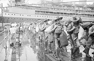
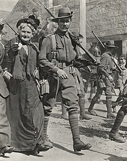
The 8th Division was an infantry division of the Australian Army, formed during World War II as part of the all-volunteer Second Australian Imperial Force. The 8th Division was raised from volunteers for overseas service from July 1940 onwards. Consisting of three infantry brigades, the intention had been to deploy the division to the Middle East to join the other Australian divisions, but as war with Japan loomed in 1941, the division was divided into four separate forces, which were deployed in different parts of the Asia-Pacific region. All of these formations were destroyed as fighting forces by the end of February 1942 during the fighting for Singapore, and in Rabaul, Ambon, and Timor. Most members of the division became prisoners of war, waiting until the war ended in late 1945 to be liberated. One in three died in captivity.
The Allies of World War II conducted an air attack upon a cruiser force at the major Japanese base of Rabaul in November 1943. In response to the Allied invasion of Bougainville, the Japanese had brought a strong cruiser force down from Truk, their major naval base in the Caroline Islands about 800 miles north of Rabaul, to Rabaul in preparation for a night engagement against the Allied supply and support shipping. Allied carrier- and land-based planes attacked the Japanese ships, airfields, and port facilities on the island of New Britain to protect the Allied amphibious invasion of Bougainville. As a result of the Rabaul raids, the Japanese naval forces could no longer threaten the landings. The success of the raid began to change the strongly held belief that carrier-based air forces could not challenge land-based air forces.

The Battle of Rabaul, also known by the Japanese as Operation R, was fought on the island of New Britain in the Australian Territory of New Guinea, in January and February 1942. It was a strategically significant defeat of Allied forces by Japan in the Pacific campaign of World War II, with the Japanese invasion force quickly overwhelming the small Australian garrison, the majority of which was either killed or captured. Hostilities on the neighbouring island of New Ireland are also usually considered to be part of the same battle. Rabaul was significant because of its proximity to the Japanese territory of the Caroline Islands, site of a major Imperial Japanese Navy base on Truk.

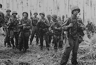
The Bougainville campaign was a series of land and naval battles of the Pacific campaign of World War II between Allied forces and the Empire of Japan, named after the island of Bougainville. It was part of Operation Cartwheel, the Allied grand strategy in the South Pacific. The campaign took place in the Northern Solomons in two phases. The first phase, in which American troops landed and held the perimeter around the beachhead at Torokina, lasted from November 1943 through November 1944.

The Rabaul caldera, or Rabaul Volcano, is a large volcano on the tip of the Gazelle Peninsula in East New Britain, Papua New Guinea, and derives its name from the town of Rabaul inside the caldera. The caldera has many sub-vents, Tavurvur being the most well known for its devastating eruptions over Rabaul. The outer flanks of the highest peak, a 688-metre-high asymmetrical pyroclastic shield, are formed by thick pyroclastic flow deposits. There is no sign of a pyroclastic shield along the rim of the caldera, making the location likely underwater, on the caldera's floor.

The Solomon Islands campaign was a major campaign of the Pacific War of World War II. The campaign began with Japanese landings and occupation of several areas in the British Solomon Islands and Bougainville, in the Territory of New Guinea, during the first six months of 1942. The Japanese occupied these locations and began the construction of several naval and air bases with the goals of protecting the flank of the Japanese offensive in New Guinea, establishing a security barrier for the major Japanese base at Rabaul on New Britain, and providing bases for interdicting supply lines between the Allied powers of the United States and Australia and New Zealand.

The New Guinea campaign of the Pacific War lasted from January 1942 until the end of the war in August 1945. During the initial phase in early 1942, the Empire of Japan invaded the Australian-administered Mandated Territory of New Guinea and the Australian Territory of Papua and overran western New Guinea, which was a part of the Netherlands East Indies. During the second phase, lasting from late 1942 until the Japanese surrender, the Allies—consisting primarily of Australian and US forces—cleared the Japanese first from Papua, then the Mandate and finally from the Dutch colony.
The New Britain campaign was a World War II campaign fought between Allied and Imperial Japanese forces. The campaign was initiated by the Allies in late 1943 as part of a major offensive which aimed to neutralise the important Japanese base at Rabaul, the capital of New Britain, and was conducted in two phases between December 1943 and the end of the war in August 1945.
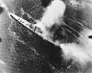
Suzunami was a Yūgumo-class destroyer of the Imperial Japanese Navy.

The Raid on Choiseul was a small unit engagement that occurred from October 28 to November 3, 1943, during the Solomon Islands campaign, and was launched to divert Japanese from the Allied landings at Cape Torokina, on Bougainville Island. During the raid, United States Marines from the 2nd Parachute Battalion, landed on Japanese occupied Choiseul in the northern Solomon Islands and carried out raids on Japanese army and navy forces over a 25-mile (40 km) area over the course of seven days with the assistance of local Choiseul islanders and an Australian coastwatcher. The force was withdrawn back to Vella Lavella by landing craft following the successful lodgment of US troops on Bougainville.
Mount Crosby is both a mountain and an outer western locality in the City of Brisbane, Australia located 22 kilometres (14 mi) south-west of the Brisbane CBD.

The 2/4th Armoured Regiment was an armoured regiment of the Australian Army, which served during World War II. The regiment was formed in November 1942 as part of the Second Australian Imperial Force by amalgamating a number of previously existing armoured units and was disbanded in September 1946 after seeing action in New Guinea and Bougainville Island, where it provided individual squadron-group sized elements which operated in support of infantry operations against the Japanese. During its service the regiment received 10 battle honours.
The Battle of Bita Paka was fought south of Kabakaul, on the island of New Britain, and was a part of the invasion and subsequent occupation of German New Guinea by the Australian Naval and Military Expeditionary Force (AN&MEF) shortly after the outbreak of the First World War. Similar to New Zealand's operation against German Samoa in August, the main target of the operation was a strategically important wireless station—one of several used by the German East Asiatic Squadron—which the Australians believed to be located in the area. The powerful German naval fleet threatened British interests and its elimination was an early priority of the British and Australian governments during the war.

Wamuran is a rural town and locality in the Moreton Bay Region, Queensland, Australia. In the 2016 census, Wamuran had a population of 3,196 people.

Operation RY was the Imperial Japanese plan to invade and occupy Nauru and Ocean islands in the south Pacific during the Pacific conflict of World War II. The operation was originally set to be executed in May 1942 immediately following Operation MO and before Operation MI, which resulted in the Battle of Midway. The primary reason for the operation was to exploit the islands' supplies of phosphate. After a postponement due to interference by enemy forces, the operation was completed in August 1942.
Wide Bay is a bay located to the south of Rabaul, on the southern coast of Gazelle Peninsula of New Britain.
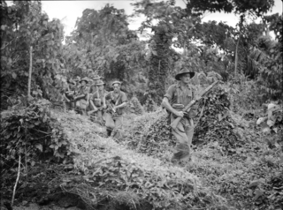
The Battle of Wide Bay–Open Bay was a battle during the New Britain campaign of the Second World War. Following the arrival of the Australians on New Britain in late 1944, replacing the US garrison on the island, they began a limited offensive against the Japanese forces on the island. Pushing east from the positions previously captured by the US troops earlier in the year, after landing at Jacquinot Bay on the southern coast in November, the Australians began advancing across the island towards the Gazelle Peninsula, where they sought to isolate the numerically superior Japanese garrison. This advance was effected along two axes: Cape Hoskins to Open Bay on the northern coast, and Jacquinot Bay to Wide Bay on the southern. Once the Australians had secured a line across the island between Wide Bay and Open Bay in March and April 1945, the fighting on New Britain died down as the Australians sought to contain the larger Japanese garrison while limiting their own casualties. This situation lasted until the end of the war in August 1945.
The 2/22nd Battalion was an infantry battalion of the Australian Army. Raised as part of the Second Australian Imperial Force for service during World War II, the battalion formed part of the 23rd Brigade, attached to the 8th Division. It was captured by the Japanese during the Battle of Rabaul in 1942. After being captured, the battalion was not re-raised and a large number of its personnel died in captivity; those that did not were returned to Australia at the end of the war in 1945.

Ataliklikun Bay is a bay of East New Britain Province, Papua New Guinea, opening into the Bismarck Sea. It is located in the northern part of New Britain, south-west of Lassul Bay and to the west of Cape Lambert and Rabaul. Urara Island is located in the northern part of the bay. The Raulavat plantation lies in the eastern part of its 25-mile shoreline. The villagers along the shore reportedly speak the Minigir language and the Masava dialect of Tolai. The United States Hydrographic Office said "a reef awash, about 200 yards long east and west, with 15 and 19 fathoms around, on which the steamer Seestem struck in 1909, lies in the south-west part of Ataliklikun Bay."

