Musa River

Last updated
Musa
Papuan Peninsula.jpg
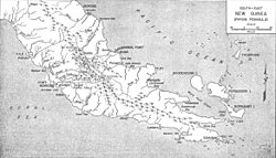
The Musa River is on the east coast, south of the latitude of Port Morsby and just north of Cape Nelson.
Location
Country Papua New Guinea
Region Gulf
Physical characteristics
Source 
  location Papua New Guinea
Mouth  
  location
Gulf of Papua, Papua New Guinea
Basin size4,813 km2 (1,858 sq mi)
Discharge 
  average319 m3/s (11,300 cu ft/s)
  minimum76 m3/s (2,700 cu ft/s)
  maximum618 m3/s (21,800 cu ft/s)

The Musa is a river on the eastern side of the Papuan Peninsula, in Papua New Guinea. It is one of the primary rivers on Oro Province. Its mouth exits into Dyke Ackland Bay. [1]

A plan to dam the river in 1975 caused local opposition. [2]

Related Research Articles

<span class="mw-page-title-main">Papua New Guinea</span> Country in Oceania

Papua New Guinea, officially the Independent State of Papua New Guinea, is a country in Oceania that comprises the eastern half of the island of New Guinea and its offshore islands in Melanesia. Its capital, located along its southeastern coast, is Port Moresby. The country is the world's third largest island country, with an area of 462,840 km2 (178,700 sq mi).

<span class="mw-page-title-main">Geography of Papua New Guinea</span> Geographical features of Papua New Guinea

The geography of Papua New Guinea describes the eastern half of the island of New Guinea, the islands of New Ireland, New Britain and Bougainville, and smaller nearby islands. Together these make up the nation of Papua New Guinea in tropical Oceania, located in the western edge of the Pacific Ocean.

<span class="mw-page-title-main">Melanesia</span> Subregion of Oceania

Melanesia is a subregion of Oceania in the southwestern Pacific Ocean. It extends from New Guinea in the west to the Fiji Islands in the east, and includes the Arafura Sea.

<span class="mw-page-title-main">Malay Archipelago</span> Archipelago between Mainland Southeast Asia and Australia

The Malay Archipelago or also called the Indo-Australian Archipelago is the archipelago between Mainland Southeast Asia and Australia. It has also been called the "Malay world," "Nusantara", "East Indies" and other names over time. The name was taken from the 19th-century European concept of a Malay race, later based on the distribution of Austronesian languages.

Lae is the capital of Morobe Province and is the second-largest city in Papua New Guinea. It is located near the delta of the Markham River and at the start of the Highlands Highway, which is the main land transport corridor between the Highlands Region and the coast. Lae is the largest cargo port of the country and is the industrial hub of Papua New Guinea. The city is known as the Garden City and home of the University of Technology.

<span class="mw-page-title-main">Gulf of Papua</span> Region on the south coast of New Guinea

The Gulf of Papua is located in the southern coast region of New Guinea. It has a total surface area of 70,400 km2 (27,200 sq mi).

<span class="mw-page-title-main">Fly River</span> River in Papua New Guinea

The Fly River is the third longest river in the island of New Guinea, after the Sepik River and Mamberamo River, with a total length of 1,060 km (660 mi). It is the largest by volume of discharge in Oceania, the largest in the world without a single dam in its catchment, and overall the 20th-largest primary river in the world by discharge volume. It is located in the southwest of Papua New Guinea and in the Papua Province of Indonesia. It rises in the Victor Emanuel Range arm of the Star Mountains, and crosses the south-western lowlands before flowing into the Gulf of Papua in a large delta. The Fly-Strickland River system has a total length of 1,220 km (760 mi), making it the longest river system of an island in the world. The 824 km (512 mi) Strickland River is the longest and largest tributary of Fly River, making it the farthest distance source of the Fly River.

<span class="mw-page-title-main">Arafura Sea</span> Marginal sea between Australia and Indonesian New Guinea

The Arafura Sea lies west of the Pacific Ocean, overlying the continental shelf between Australia and Western New Guinea, which is the Indonesian part of the Island of New Guinea.

The Markham Valley is a geographical area in Papua New Guinea. The name "Markham" commemorates Sir Clements Markham, Secretary of the British Royal Geographical Society - Captain John Moresby of the Royal Navy named the Markham River after Sir Clements in the course of his voyage of exploration in HMS Basilisk in 1873. The valley contains two districts of Morobe Province: Huon Gulf district on the east and Markham district on the west. The inhabitants of the valley are of Oceanic (Austronesian) descent and live in large villages under a chieftain political system.

<span class="mw-page-title-main">Mambare River</span>

Mambare River is a river in Oro Province, Papua New Guinea, located at 8.05°S 148.0333333°E.

The Yareban or Musa River languages are a small family of Trans–New Guinea languages spoken near the Musa River in the "Bird's Tail" of New Guinea. They are classified within the Southeast Papuan branch of Trans–New Guinea.

<span class="mw-page-title-main">Southeast Papuan languages</span> Language group of New Guinea

The Southeast Papuan or Papuan Peninsula languages are a group of half a dozen small families of Papuan languages in the "Bird's Tail" of New Guinea that are part of the Trans–New Guinea (TNG) phylum.

<span class="mw-page-title-main">New Guinea</span> Island in the Pacific Ocean

New Guinea is the world's second-largest island, with an area of 785,753 km2 (303,381 sq mi). Located in Oceania in the southwestern Pacific Ocean, the island is separated from Australia by the 150-kilometre wide Torres Strait, though both landmasses lie on the same continental shelf. Numerous smaller islands are located to the west and east.

<span class="mw-page-title-main">Solomon Islands (archipelago)</span> Archipelago in the South Pacific spreading over two countries

The Solomon Islands (archipelago) is an island group in the western South Pacific Ocean, north-east of Australia. The archipelago is in the Melanesian subregion and bioregion of Oceania and forms the eastern boundary of the Solomon Sea. The many islands of the archipelago are distributed across Papua New Guinea and Solomon Islands (country). The largest island in the archipelago is Bougainville Island, which is a part of the Autonomous Region of Bougainville along with Buka Island, the Nukumanu Islands, and a number of smaller nearby islands. Much of the remainder falls within the territory of Solomon Islands and include the atolls of Ontong Java, Sikaiana, the raised coral atolls of Bellona and Rennell, and the high islands of Choiseul, Guadalcanal, Makira, Malaita, New Georgia, the Nggelas, Santa Isabel, and the Shortlands. The Santa Cruz Islands are not a part of the archipelago.

<span class="mw-page-title-main">Pawaia language</span> Pawala language spoken in Papua New Guinea

Pawaia, also known as Sira, Tudahwe, Yasa, is a Papuan language that forms a tentative independent branch of the Trans–New Guinea family in the classification of Malcolm Ross (2005).

The Afai is a river of south-eastern central Papua New Guinea. Namudi Airport lies along the river.

The Girua River is a river located in the Oro Province of Papua New Guinea.

Nauna is an Oceanic language spoken in the single village of Nauna on Nauna Island in Rapatona Rural LLG, Manus Province, Papua New Guinea.

The Veimauri is a river of Papua New Guinea. It flows into Galley Reach of Redscar Bay to the north-west of Port Moresby. To the east of the mouth there are rubber and coconut plantations on the banks and the Veimauri River Bridge. The river area is protected under the Veimauri River Forest Reserve, which has a significant population of parrots.

References

Coordinates: 9°03′S148°55′E / 9.050°S 148.917°E / -9.050; 148.917