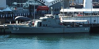
HMAS Aitape was an Attack class patrol boat of the Royal Australian Navy (RAN). It was named for the small town of Aitape, Sandaun Province, Papua New Guinea. Completed in 1967, the vessel was one of five assigned to the RAN's Papua New Guinea (PNG) Division. The patrol boat was transferred to the Papua New Guinea Defence Force in 1974 as HMPNGS Aitape. She remained active until 1982, when she was removed from service for use as a parts hulk. Aitape was scuttled off Port Moresby for use as a dive wreck in 1995.

Wewak is the capital of the East Sepik province of Papua New Guinea. It is on the northern coast of the island of New Guinea. It is the largest town between Madang and Jayapura. It is the see city (seat) of the Roman Catholic Diocese of Wewak.

Aitape is a small town of about 18,000 people on the north coast of Papua New Guinea in the Sandaun Province. It is a coastal settlement that is almost equidistant from the provincial capitals of Wewak and Vanimo, and marks the midpoint of the highway between these two capitals. Aitape has 240 V power, telephone, a bank, a post-office, a courthouse and a police station, a supermarket and many tradestores, a petrol station, two airstrips, two secondary schools, a mission office and a hospital.
Sissano is an Austronesian language spoken by at most a few hundred people around Sissano in West Aitape Rural LLG, Sandaun Province, Papua New Guinea. 4,800 speakers were reported in 1990, but the 1998 tsunami wiped out most of the population.

The 1998 Papua New Guinea earthquake occurred on July 17 with a moment magnitude of 7.0 and a maximum Mercalli intensity of VIII (Severe). The event occurred on a reverse fault near the north coast region of Papua New Guinea, 25 kilometers (16 mi) from the coast near Aitape, and caused a large undersea landslide which caused a tsunami that hit the coast, killing between at least 2,183 and 2,700 people and injuring thousands.

This page is a list of districts of Papua New Guinea.

Aitape-Lumi District is a district of Sandaun Province of Papua New Guinea. Its capital is Aitape. The provincial administration is called the Sandaun Provincial Administration. The provincial capital is Vanimo, about 200 km up the northwest coastline.

The Sepik River is the longest river on the island of New Guinea, and the second largest in Oceania by discharge volume after the Fly River. The majority of the river flows through the Papua New Guinea (PNG) provinces of Sandaun and East Sepik, with a small section flowing through the Indonesian province of Papua.
Tadji is a small town on the north coast of Papua New Guinea in Aitape Urban ward of East Aitape Rural LLG, Sandaun Province. Tadji is located to the east of Aitape. The town is home to Tadji Airport, which was built by the Japanese in 1942 during the World War II. The liberation of Tadji was the focus of Operation Persecution during April 1944, when the Allies captured the airstrip.
Yakamul, also known as Kap or Ali, is an Austronesian language spoken in East Aitape Rural LLG, Sandaun Province, Papua New Guinea. It is spoken in the village of Yakamul on the north coast and on the islands of Ali, Angel, and Seleo islands.
Tumleo is an Austronesian language of coastal Sandaun Province, Papua New Guinea, on Tumleo Island and the Aitape coast in East Aitape Rural LLG.
Sera (Ssia) is an Austronesian language of coastal Sandaun Province, Papua New Guinea. It is spoken in only one village, namely Sera village of West Aitape Rural LLG, Sandaun Province.
Arop-Sissano, or Arop, is an Austronesian language of Arop village in West Aitape Rural LLG, coastal Sandaun Province, Papua New Guinea.

East Aitape Rural LLG is a local-level government (LLG) of Sandaun Province, Papua New Guinea. Arapesh and Schouten languages are spoken in this LLG.
West Aitape Rural LLG is a local-level government (LLG) of Sandaun Province, Papua New Guinea. The Piore River languages and Oceanic languages such as Sissano are spoken in the LLG.

Sissano Lagoon is a lagoon located in West Aitape Rural LLG, Sandaun Province, Papua New Guinea.
Tumleo or Tumeleo is a populated island in East Aitape Rural LLG, Sandaun Province, Papua New Guinea.
Ali Island is a populated island in East Aitape Rural LLG, Sandaun Province, Papua New Guinea.
Seleo Island is a populated island in East Aitape Rural LLG, Sandaun Province, Papua New Guinea.
On September 9, 2002, a magnitude 7.6 earthquake struck Papua New Guinea, causing at least six deaths and moderate damage.
