
Papua New Guinea, officially the Independent State of Papua New Guinea, is a country in Oceania that comprises the eastern half of the island of New Guinea and its offshore islands in Melanesia. Its capital, located along its southeastern coast, is Port Moresby. It is the world's third largest island country with 462,840 km2 (178,700 sq mi).

The prehistory of Papua New Guinea can be traced to about 50,000 - 60,000 years ago, when people first migrated towards the Australian continent. The written history began when European navigators first sighted New Guinea in the early part of the 17th century.
The Sko or Skou languages are a small language family spoken by about 7000 people, mainly along the Vanimo coast of Sandaun Province in Papua New Guinea, with a few being inland from this area and at least one just across the border in the Indonesian province of Papua.

Western New Guinea, also known as Papua, is the western portion of the island of New Guinea controlled by Indonesia since 1962. Since the island is alternatively named as Papua, the region is also called West Papua. Lying to the west of Papua New Guinea, it is the only Indonesian territory situated in Oceania. Considered to be a part of the Australian continent, the territory is mostly in the Southern Hemisphere and includes the Schouten and Raja Ampat archipelagoes. The region is predominantly covered with ancient rainforest where numerous traditional tribes live such as the Dani of the Baliem Valley although a large proportion of the population live in or near coastal areas with the largest city being Jayapura.

Western Province is a coastal province in southwestern Papua New Guinea, bordering the Indonesian province of Papua. The provincial capital is Daru. The largest town in the province is Tabubil. Other major settlements are Kiunga, Ningerum, Olsobip and Balimo.

East Sepik is a province in Papua New Guinea. Its capital is Wewak. East Sepik has an estimated population of 433,481 people and is 43,426 km square in size.

The Trans-Fly – Bulaka RiverakaSouth-Central Papuan languages form a hypothetical family of Papuan languages. They include many of the languages west of the Fly River in southern Papua New Guinea into southern Indonesian West Papua, plus a pair of languages on the Bulaka River a hundred km further west.
Bayono–Awbono is a recently discovered Papuan language cluster spoken in Papua Province, Indonesia, to the south of the Somahai languages. All that is known of them is a few hundred words recorded in first-contact situations recorded in Wilbrink (2004) and Hischier (2006).

Papua New Guinea, a sovereign state in Oceania, is the most linguistically diverse country in the world. According to Ethnologue, there are 839 living languages spoken in the country. In 2006, Papua New Guinea Prime Minister Sir Michael Somare stated that "Papua New Guinea has 832 living languages ." Languages with statutory recognition are Tok Pisin, English, Hiri Motu, and Papua New Guinean Sign Language. Tok Pisin, an English-based creole, is the most widely spoken, serving as the country's lingua franca. Papua New Guinean Sign Language became the fourth officially recognised language in May 2015, and is used by the deaf population throughout the country.
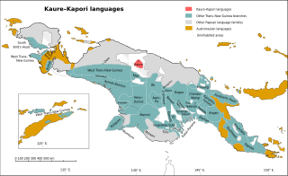
The Kaure–Kosare or Nawa River languages are a small family spoken along the Nawa River in West Papua, near the northern border with Papua New Guinea. The languages are Kaure and Kosare.

The Turama–Kikorian languages are a family identified by Arthur Capell (1962) and part of the Trans–New Guinea languages (TNG) family in the classifications of Stephen Wurm (1975) and Malcolm Ross (2005). The family is named after the Turama River and Kikori River of southern Papua New Guinea; the alternative name is based more narrowly on the Omati River.

The Southeast Papuan or Papuan Peninsula languages are a group of half a dozen small families of Papuan languages in the "Bird's Tail" of New Guinea that are part of the Trans–New Guinea (TNG) phylum.

New Guinea is the world's second-largest island, and with an area of 785,753 km2 (303,381 sq mi), the largest island in the Southern Hemisphere. Located in Melanesia in the southwestern Pacific Ocean, it is separated by the 150 km wide Torres Strait from the Australian continent. Numerous smaller islands are located to the west and east. The eastern half of the island is the major land mass of the independent state of Papua New Guinea. The western half, known as Western New Guinea or West Papua, forms a part of Indonesia and is organized as the provinces of Papua and West Papua.

The Yam languages, also known as the Morehead River languages, are a family of Papuan languages. They include many of the languages south and west of the Fly River in Papua New Guinea and Indonesian West Papua.

The Sepik River is the longest river on the island of New Guinea, and after the Fly and the Mamberamo the third largest by volume. The majority of the river flows through the Papua New Guinea (PNG) provinces of Sandaun and East Sepik, with a small section flowing through the Indonesian province of Papua.

Pawaia, also known as Sira, Tudahwe, Yasa, is a Papuan language that forms a tentative independent branch of the Trans–New Guinea family in the classification of Malcolm Ross (2005).

Mount Victory is an active volcano on the north east coast of Oro Province, Papua New Guinea with a height of 1,884 metres (6,181 ft). It is bounded by the Ajova River.

The Papuan Gulf languages are a proposed language family of Papuan languages spoken inland from the large gulf that defines the shape of southern Papua New Guinea.
The Bensbach River is a river in southwestern Papua New Guinea. It is located just to the east of the Maro River in Merauke Regency, Indonesia, and just to the west of the Morehead River in Papua New Guinea.
