
Papua New Guinea, officially the Independent State of Papua New Guinea, is a country in Oceania that comprises the eastern half of the island of New Guinea and its offshore islands in Melanesia. Its capital, located along its southeastern coast, is Port Moresby. The country is the world's third largest island country with an area of 462,840 km2 (178,700 sq mi).

The geography of Papua New Guinea describes the eastern half of the island of New Guinea, the islands of New Ireland, New Britain and Bougainville, and smaller nearby islands. Together these make up the nation of Papua New Guinea in tropical Oceania, located in the western edge of the Pacific Ocean.

East Sepik is a province in Papua New Guinea. Its capital is Wewak. East Sepik has an estimated population of 433,481 people and is 43,426 km square in size.

The Trans-Fly – Bulaka RiverakaSouth-Central Papuan languages form a hypothetical family of Papuan languages. They include many of the languages west of the Fly River in southern Papua New Guinea into southern Indonesian West Papua, plus a pair of languages on the Bulaka River a hundred km further west.
The Nimboran languages are a small family of Papuan languages, spoken in the Grime River watershed, that had been part of Stephen Wurm's Trans–New Guinea proposal. However, when proto-Nimboran pronouns are reconstructed (*genam "I" and kom or komot "thou"), they have little resemblance to the proto-TNG pronouns *na and *ga. Usher places them in a North Papuan stock that resembles Cowan's proposal.

Fitiuta Airport is a public airport located in Fiti‘uta, a village on the island of Ta‘ū in American Samoa, an unincorporated territory of the United States. Fitiuta Airport replaced Tau Airport, which was officially deactivated after the construction and activation of Fitiuta Airport in 1990. The Fitiuta airport is owned by the Government of American Samoa.

Mining in Papua New Guinea is an important part of the Papua New Guinea economy.
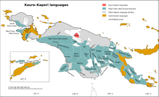
The Kaure–Kosare or Nawa River languages are a small family spoken along the Nawa River in West Papua, near the northern border with Papua New Guinea. The languages are Kaure and Kosare.

The Turama–Kikorian languages are a family identified by Arthur Capell (1962) and part of the Trans–New Guinea languages (TNG) family in the classifications of Stephen Wurm (1975) and Malcolm Ross (2005). The family is named after the Turama River and Kikori River of southern Papua New Guinea; the alternative name is based more narrowly on the Omati River.

The Kamula–Elevala languages are a small family of the Trans–New Guinea languages spoken in the region of the Elevala River.

New Guinea is the world's second-largest island with an area of 785,753 km2 (303,381 sq mi). Located in Oceania in the southwestern Pacific Ocean, the island is separated by the 150 km wide Torres Strait from Australia. Numerous smaller islands are located to the west and east. The eastern half of the island is the major land mass of the independent state of Papua New Guinea. The western half, known as Western New Guinea, forms a part of Indonesia and is organized as the provinces of Papua and West Papua. The largest cities on the island are Jayapura and Port Moresby.

The Yam languages, also known as the Morehead River languages, are a family of Papuan languages. They include many of the languages south and west of the Fly River in Papua New Guinea and Indonesian West Papua.
The Papi and Asaba languages form a small family of two somewhat distantly related languages of northern Papua New Guinea, namely Papi and Suarmin (Asaba).
Frieda River Airport is an airfield serving the Frieda River area in Papua New Guinea. It is located near the border between the provinces of West Sepik (Sandaun) and East Sepik. The area has a gold and copper mine known as the Frieda River Project. The airfield is located 428 nautical miles northwest of Port Moresby, the capital and largest city of Papua New Guinea.
The Frieda River Project is a large open cast mine and associated infrastructure in the Sandaun and East Sepik Provinces of Papua New Guinea. The mine is located along a tributary of the Sepik River. The deposit is a large copper-gold porphyry deposit. The project includes a hydroelectric scheme to provide electricity. and service by the Frieda River Airport. In 2010, the mine had estimated reserves of 14.3 million oz of gold.

Pawaia, also known as Sira, Tudahwe, Yasa, is a Papuan language that forms a tentative independent branch of the Trans–New Guinea family in the classification of Malcolm Ross (2005).
Binandere is a Papuan language spoken in the "tail" of Papua New Guinea.

Jiwaka is a province of Papua New Guinea. The provincial capital is temporarily located in Kurumul. Mostly all provincial matters are handled in Kurumul while few are handled in Banz and Minj.

The Papuan Gulf languages are a proposed language family of Papuan languages spoken inland from the large gulf that defines the shape of southern Papua New Guinea.
