
Macomb Township is a civil township within Metro Detroit in Macomb County in the U.S. state of Michigan. The township's population was 50,477 at the 2000 census. At the 2010 census, the population grew to 79,580, which ranked Macomb Township as the most-populated civil township in the state of Michigan. Its numbers have since grown to 91,579 as of 2020. It is the third most-populated township in the state after the charter townships of Clinton and Canton.

Centerville is a borough in Washington County, Pennsylvania, United States. The population was 3,263 at the 2010 census.

Avonmore is a borough in Westmoreland County, Pennsylvania, United States. The population was 1,011 at the 2010 census.
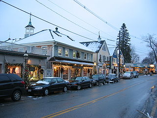
Kennebunkport is a census-designated place (CDP) consisting of the central village in the town of Kennebunkport in York County, Maine, United States. The population was 1,238 at the 2010 census, out of a total town population of 3,474. It is part of the Portland–South Portland–Biddeford, Maine Metropolitan Statistical Area.

The Bught is an area of the Scottish city of Inverness.A "bught" is defined in the Dictionary of the Scots Language as follows "Bowcht, Bucht, n. Also: boucht; bowght, bought. [Flem. bocht, bucht, inclosure for swine, sheep, etc.] A sheep-fold; a milking fold for ewes."

Gobler is an unincorporated community on the border between Dunklin and Pemiscot counties in the U.S. state of Missouri. It is located nineteen miles west-southwest of Caruthersville and seven miles southeast of Kennett. The community is on Missouri Route NN and the old St. Louis Southwestern Railway line which is now Dunklin County Road 710.
Parkgrove is a suburb of Edinburgh, the capital of Scotland. Approximately 4 miles north-west of Edinburgh city centre. The suburb is located between the neighbouring areas of Clermiston, Barnton and Davidson's Mains.

Walther-Schreiber-Platz is a Berlin U-Bahn station located on the line in Steglitz-Zehlendorf. Built from 1967 to 1969, the station is located completely under the Bundesallee, which flows into Walther-Schreiber-Platz. The station was opened on January 29, 1971, and until September 1974 was the southern terminus of the former Line 9.

Dundee is a township municipality in Le Haut-Saint-Laurent Regional County Municipality in the Montérégie administrative region of Quebec, Canada. At the Canada 2011 Census, the population was 408. It is primarily an agricultural area consisting of dairy and grain farms.

Nawiliwili Beach Park is a beach park and port on the south-east coast of the island of Kauai in the Hawaiian Islands. It is located on Nāwiliwili Bay at 21°57′33″N159°21′10″W, about 1.9 miles (3.1 km) south of Līhuʻe. It is at the south end of Hawaii Route 51, known as Rice Street. Just to the west is Niumalu Beach Park. Across Nāwiliwili Bay is Kawai Point.
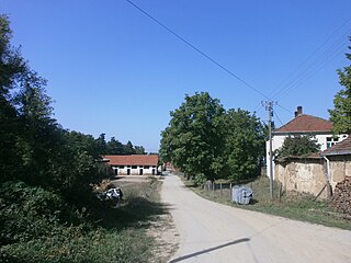
Čukljenik is a village in the municipality of Leskovac, Serbia. According to the 2002 census, the village has a population of 636 people.

Vražogrnac is a village in the municipality of Zaječar, Serbia. According to the 2002 census, the village has a population of 1340 people.

The Transfiguration Cathedral on a steep bluff overlooking the Amur River in Khabarovsk stands 96 meters tall and is supposed to be the third tallest church in Russia after St. Isaac's Cathedral and the Cathedral of Christ the Saviour. It was built over 2001-2004 to a traditional design reminiscent of Konstantin Thon's works. The church is surmounted by four Ukrainian-style gilded domes, the central one being the largest. Its spectacular location on a hill was chosen by Patriarch of Moscow and all Rus' Alexis II of Moscow during a helicopter flight over Khabarovsk.

Lenkerville is an unincorporated community and census-designated place in Upper Paxton Township, Dauphin County, Pennsylvania, United States. It is less than a mile south of the borough of Millersburg along Pennsylvania Route 147, which lies on the east bank of the Susquehanna River. As of the 2010 census the population was 550.
Golovnin Bay is a waterway in the U.S. state of Alaska. It is a part of Norton Sound. It is named in honor of Vasily Golovnin. Fish River empties into the bay. Situated on the Seward Peninsula, it is the only protected waterway south of Port Clarence.
Beaver Island is a heavily forested and uninhabited island located on the Deerfield River in Rowe, Massachusetts.
Farmingdale is an unincorporated community in Pennington County, in the U.S. state of South Dakota.

Atalaya is a ward (barrio) of Madrid belonging to the district of Ciudad Lineal.

North Fork is a census-designated place (CDP) in Navajo County, Arizona, United States, on the Fort Apache Indian Reservation. The population was 1,417 at the 2010 census.
Beach is an unincorporated community in northwestern Webster County, in the U.S. state of Missouri. The community is located on Missouri Route W, approximately six miles north-northwest of Marshfield.