
Papua New Guinea, officially the Independent State of Papua New Guinea, is a country in Oceania that comprises the eastern half of the island of New Guinea and its offshore islands in Melanesia. Its capital, located along its southeastern coast, is Port Moresby. The country is the world's third largest island country with an area of 462,840 km2 (178,700 sq mi).

Western New Guinea, also known as Papua or Indonesian New Guinea, is the western portion of New Guinea administered by Indonesia. Since the island is alternatively named as Papua, the region is also called West Papua. Lying to the west of Papua New Guinea and considered part of the Australian continent, the territory is mostly in the Southern Hemisphere and includes the Schouten and Raja Ampat archipelagoes. The region is predominantly covered with ancient rainforest where numerous traditional tribes live such as the Dani of the Baliem Valley although a large proportion of the population live in or near coastal areas with the largest city being Jayapura.
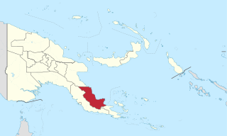
Oro Province, formerly Northern Province, is a coastal province of Papua New Guinea. The provincial capital is Popondetta. The province covers 22,800 km2, and has 176,206 inhabitants. The province shares land borders with Morobe Province to the northwest, Central Province to the west and south, and Milne Bay Province to the southeast. The province is located within the Papuan Peninsula.

The Sepik or Sepik River languages are a family of some 50 Papuan languages spoken in the Sepik river basin of northern Papua New Guinea, proposed by Donald Laycock in 1965 in a somewhat more limited form than presented here. They tend to have simple phonologies, with few consonants or vowels and usually no tones.
Momuna (Momina), also known as Somahai, is a Papuan language spoken in the highlands of Papua province, Indonesia.

New Guinea is the world's second-largest island with an area of 785,753 km2 (303,381 sq mi). Located in Oceania in the southwestern Pacific Ocean, the island is separated by the 150 km wide Torres Strait from Australia. Numerous smaller islands are located to the west and east. The eastern half of the island is the major land mass of the independent state of Papua New Guinea. The western half, known as Western New Guinea, forms a part of Indonesia and is organized as the provinces of Papua and West Papua. The largest cities on the island are Jayapura and Port Moresby.

The Upper Sepik languages are a group of ten to a dozen languages generally classified among the Sepik languages of northern Papua New Guinea.

The Bulaka River languages are a pair of closely related Papuan languages, Yelmek and Maklew, on the Bulaka River in Indonesian West Papua. They are ethnically Yab (Jab); their speech is Yabga (Jabga).
The Ram languages are a small group of 3 languages spoken in Sandaun Province, Papua New Guinea. They are spoken directly to the northeast of the Yellow River languages and directly to the south of the Wapei languages, both of which are also Sepik groups. Ram is the word for 'man' in the languages that make up this group.
The Yellow River languages are a small family of clearly related languages,

Mor is a nearly extinct Trans–New Guinea language of Indonesia. It is spoken along the Budidi River and the Bomberai River on the Bomberai Peninsula.

Pawaia, also known as Sira, Tudahwe, Yasa, is a Papuan language that forms a tentative independent branch of the Trans–New Guinea family in the classification of Malcolm Ross (2005).
Namia is a Sepik language spoken in Namea Rural LLG, Sandaun Province, Papua New Guinea. It goes by various names, such as Edawapi, Lujere, Yellow River. Language use is "vigorous" (Ethnologue).
Binandere is a Papuan language spoken in the "tail" of Papua New Guinea.
Mandobo, or Kaeti, is a Papuan language of Mandobo District in Boven Digoel Regency, Papua, Indonesia.

The Bamu River is a river in southwestern Papua New Guinea.
The Nuru River is a river in northern Papua New Guinea.
Segero Creek is a creek located in Western Province, Papua New Guinea.
The Samaia River or Simaia River is a river in Sandaun Province, Papua New Guinea. The river flows through Green River Rural LLG.
