
Papua New Guinea, officially the Independent State of Papua New Guinea, is a country in Oceania that comprises the eastern half of the island of New Guinea and its offshore islands in Melanesia. Its capital, located along its southeastern coast, is Port Moresby. The country is the world's third largest island country, with an area of 462,840 km2 (178,700 sq mi).
The Sko or Skou languages are a small language family spoken by about 7000 people, mainly along the Vanimo coast of Sandaun Province in Papua New Guinea, with a few being inland from this area and at least one just across the border in the Indonesian province of Papua.

Western New Guinea, also known as Papua, Indonesian New Guinea, Indonesian Papua, is the western, Indonesian half of the island of New Guinea. Since the island is alternatively named as Papua, the region is also called West Papua.

Western Province is a coastal province in southwestern Papua New Guinea, bordering the Indonesian provinces of Highland Papua and South Papua. The provincial capital is Daru. The largest town in the province is Tabubil. Other major settlements are Kiunga, Ningerum, Olsobip and Balimo.

Luigi Maria D'Albertis was an Italian naturalist and explorer who, in 1875, became the first Italian to chart the Fly River in what is now called Papua New Guinea. He undertook three voyages up this river from 1875 to 1877. The first was conducted in the steamer SS Ellengowan and the other two in a smaller ship named the "Neva" which was chartered from the Government of New South Wales. Throughout the three voyages, D'Albertis was consistently involved in skirmishes with the various indigenous people living along the river, using rifle-fire, rockets and dynamite to intimidate and, on occasions, kill these local people. He also frequently employed destructive dynamite fishing as a technique of obtaining aquatic specimens for his collection. His expedition stole many ancestral remains, tools and weapons from the houses of the locals. He also collected specimens of birds, plants, insects and the heads of recently killed native people. Contemporary explorers and colonial administrators of d'Albertis were almost universally critical of the methods employed by D'Albertis in his expeditions up the Fly and more modern accounts, such as Goode's "Rape of the Fly" are equally condemnatory.

The Trans-Fly – Bulaka RiverakaSouth-Central Papuan languages form a hypothetical family of Papuan languages. They include many of the languages west of the Fly River in southern Papua New Guinea into southern Indonesian West Papua, plus a pair of languages on the Bulaka River a hundred km further west.
Richard Archbold was an American zoologist and philanthropist. He was independently wealthy, being the grandson of the capitalist John Dustin Archbold. He was educated at private schools, and later attended classes at Columbia University though he never graduated. He used his share of his family's wealth first to sponsor a series of biological expeditions to New Guinea for the American Museum of Natural History, and later to establish, maintain and endow a biological research station in Florida. In 1929, Archbold joined the ranks of members of the Explorers Club in New York.

Talbot Islands are a group of Torres Strait Islands in Queensland, Australia. They lie between the Australian mainland and the island of New Guinea and a few kilometres west of Saibai Island, Torres Strait, only 4 km from the Papua New Guinea mainland at the mouth of the Mai Kussa River.
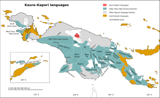
The Kaure–Kosare or Nawa River languages are a small family spoken along the Nawa River in West Papua, near the northern border with Papua New Guinea. The languages are Kaure and Kosare.

The Turama–Kikorian languages are a family identified by Arthur Capell (1962) and part of the Trans–New Guinea languages (TNG) family in the classifications of Stephen Wurm (1975) and Malcolm Ross (2005). The family is named after the Turama River and Kikori River of southern Papua New Guinea; the alternative name is based more narrowly on the Omati River.

New Guinea is the world's second-largest island, with an area of 785,753 km2 (303,381 sq mi). Located in Melanesia in the southwestern Pacific Ocean, the island is separated from Australia by the 150-kilometre wide Torres Strait, though both landmasses lie on the same continental shelf. Numerous smaller islands are located to the west and east.

The Yam languages, also known as the Morehead River languages, are a family of Papuan languages. They include many of the languages south and west of the Fly River in Papua New Guinea and Indonesian West Papua.

The Sepik is the longest river on the island of New Guinea, and the second largest in Oceania by discharge volume after the Fly River. The majority of the river flows through the Papua New Guinea (PNG) provinces of Sandaun and East Sepik, with a small section flowing through the Indonesian province of Papua.

Pawaia, also known as Sira, Tudahwe, Yasa, is a Papuan language that forms a tentative independent branch of the Trans–New Guinea family in the classification of Malcolm Ross (2005).
Mandobo, or Kaeti, is a Papuan language of Mandobo District in Boven Digoel Regency, Papua, Indonesia.
Nambu is a cluster of Papuan languages spoken in the Morehead River region of Papua New Guinea.

The Papuan Gulf languages are a proposed language family of Papuan languages spoken inland from the large gulf that defines the shape of southern Papua New Guinea.
Arthrochilus laevicallus is a species of flowering plant in the orchid family (Orchidaceae) and is endemic to Papua New Guinea. It is leafless but has up to seven green, insect-like flowers with dark reddish glands on its labellum.

Calochilus caeruleus, commonly known as the wiry beard orchid, is a species of orchid native to northern Australia and New Guinea. It has a single leaf which continues to develop during flowering and up to twelve greenish flowers with reddish brown markings and a labellum with a red "beard".
